Property Record
10107 Stardust Trl, Milton, FL 32583


This Property Is For Sale
NEARBY LISTINGS FOR SALE OR LEASE
Property Detail
10107 Stardust Trl
Pensacola-Ferry Pass-Brent, FL
Spaner Subdivision
12-1N-27-0000-00509-0000
*DESCRIPTION UPDATE FOR 2023* COM AT SW CORN OF NE4 OF SE4 OF SECTION 12 TOWNSHIP 1 NORTH RANGE N27 WEST FOR POB THN N 635 FT THN E 585 FT THN S 635 FT THN W 585 FT TO POB AS DES IN OR 1033 PG 230 & ALL AS DES IN OR 4345 PG 1393
Commercialacreage
Santa Rosa
X
Florida
12113C0460H
8.53 AC
2024
SE Santa Rosa County
2025
Pensacola
010808
DEMOGRAPHICS near 10107 Stardust Trl
1 mile
3 mile
5 mile
2024 Total Population
911
3,063
10,270
2029 Population
994
3,344
11,141
Pop Growth 2024-2029
+ 9.11%
+ 9.17%
+ 8.48%
Average Age
42
42
42
2024 Total Households
336
1,105
2,829
HH Growth 2024-2029
+ 8.63%
+ 9.05%
+ 9.90%
Median Household Inc
$54,062
$55,282
$62,970
Avg Household Size
2.50
2.50
2.50
2024 Avg HH Vehicles
2.00
2.00
2.00
Median Home Value
$142,353
$143,866
$202,019
Median Year Built
2002
2002
2001
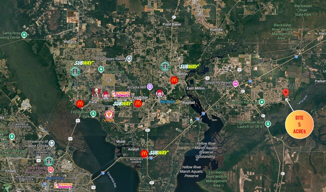
Nearby Places
Map Layers
Map Styles
 Street
 Aerial
Transit
 Traffic
 Biking
Places
Listings with unknown addresses are not visible on the map
- Restaurants
- Banks
- Shops
- Fitness
- Groceries
PUBLIC TRANSPORTATION
AIRPORT
Pensacola International
Drive
Walk
Distance
Pensacola International
43 min
27.1 mi
Freight Ports
Port of Mobile
Drive
Walk
Distance
Port of Mobile
92 min
77.2 mi
Nearby Properties
Address
Land Use
TOTAL SIZE
Lot Size
Zoning
Address
Land Use
TOTAL SIZE
Lot Size
Zoning
246.44 AC
AG-RR
Address
Land Use
TOTAL SIZE
Lot Size
Zoning
29,331 SF
8.54 AC
M1
Address
Land Use
TOTAL SIZE
Lot Size
Zoning
640 AC
MIL
Address
Land Use
TOTAL SIZE
Lot Size
Zoning
32 AC
HCD
Address
Land Use
TOTAL SIZE
Lot Size
Zoning
9,301 SF
1.33 AC
HCD
Address
Land Use
TOTAL SIZE
Lot Size
Zoning
4,950 SF
33.84 AC
HCD
Address
Land Use
TOTAL SIZE
Lot Size
Zoning
640 AC
MIL
Address
Land Use
TOTAL SIZE
Lot Size
Zoning
2,787 SF
108.12 AC
R1
Address
Land Use
TOTAL SIZE
Lot Size
Zoning
18 AC
HCD
Address
Land Use
TOTAL SIZE
Lot Size
Zoning
11.76 AC
HCD
Address
Land Use
TOTAL SIZE
Lot Size
Zoning
13,483 SF
24.92 AC
AG-RR
Address
Land Use
TOTAL SIZE
Lot Size
Zoning
5,376 SF
2.75 AC
HCD
Address
Land Use
TOTAL SIZE
Lot Size
Zoning
3,208 SF
44.80 AC
AG-RR
Address
Land Use
TOTAL SIZE
Lot Size
Zoning
8,589 SF
11 AC
AG-RR
Address
Land Use
TOTAL SIZE
Lot Size
Zoning
3,740 SF
6 AC
HCD
Address
Land Use
TOTAL SIZE
Lot Size
Zoning
23,610 SF
40 AC
AG-RR
Address
Land Use
TOTAL SIZE
Lot Size
Zoning
5,987 SF
27.92 AC
AG-RR
Address
Land Use
TOTAL SIZE
Lot Size
Zoning
8,327 SF
11.28 AC
AG-RR
Address
Land Use
TOTAL SIZE
Lot Size
Zoning
7,448 SF
1.14 AC
AG-RR
Address
Land Use
TOTAL SIZE
Lot Size
Zoning
4,654 SF
7.35 AC
AG-RR
Address
Land Use
TOTAL SIZE
Lot Size
Zoning
5,507 SF
1 AC
AG-RR
Address
Land Use
TOTAL SIZE
Lot Size
Zoning
9.67 AC
M1
Address
Land Use
TOTAL SIZE
Lot Size
Zoning
4,534 SF
2.30 AC
AG-RR
Address
Land Use
TOTAL SIZE
Lot Size
Zoning
6,006 SF
73.54 AC
HCD
Address
Land Use
TOTAL SIZE
Lot Size
Zoning
4,896 SF
1.62 AC
AG-RR
Address
Land Use
TOTAL SIZE
Lot Size
Zoning
3,681 SF
1 AC
AG-RR
Address
Land Use
TOTAL SIZE
Lot Size
Zoning
3,984 SF
1 AC
AG-RR
Address
Land Use
TOTAL SIZE
Lot Size
Zoning
4,428 SF
6.77 AC
AG-RR
The World's #1 Commercial Real Estate Marketplace
Connect with us
© 2026 CoStar Group
The information above has been obtained from sources believed reliable. While we do not doubt its accuracy we have not verified it and make no guarantee, warranty or representation about it. It is your responsibility to independently confirm its accuracy and completeness. Any projections, opinions, assumptions, or estimates used are for example only and do not represent the current or future performance of the property. The value of this transaction to you depends on tax and other factors which should be evaluated by your tax, financial, and legal advisors. You and your advisors should conduct a careful, independent investigation of the property to determine to your satisfaction the suitability of the property for your needs.