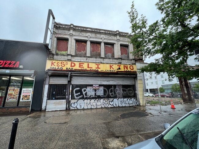
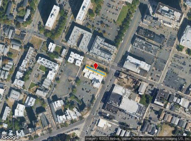
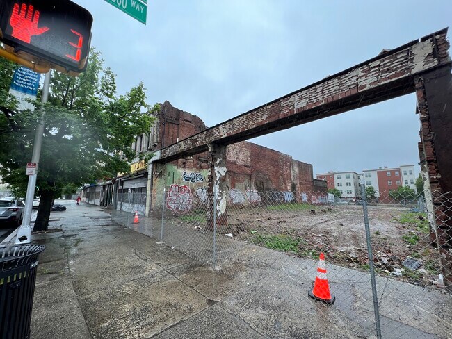
Property Record
1011 Broad St, Newark, NJ 07102
NEARBY LISTINGS FOR SALE OR LEASE
Property Detail
1011 Broad St
14-00118-0000-00003
31.4X204.3
Commercialnec
Essex
X
New Jersey
34013C0156F
3
2023
0.15 AC
2025
Newark
015200
Northern New Jersey
477 SF
Newark, NJ
DEMOGRAPHICS near 1011 Broad St
1 Mile
3 Mile
5 Mile
2024 Total Population
55,113
336,417
761,417
2029 Population
53,799
324,774
736,879
Pop Growth 2024-2029
(2.38%)
(3.46%)
(3.22%)
Average Age
37
36
38
2024 Total Households
21,887
121,409
276,066
HH Growth 2024-2029
(2.26%)
(3.50%)
(3.33%)
Median Household Inc
$40,498
$45,398
$56,143
Avg Household Size
2.40
2.60
2.60
2024 Avg HH Vehicles
1.00
1.00
1.00
Median Home Value
$314,858
$299,226
$348,666
Median Year Built
1978
1964
1958
Nearby Places
Map Layers
Map Styles
 Street
 Aerial
- Restaurants
- Banks
- Shops
- Fitness
- Groceries
PUBLIC TRANSPORTATION
TRANSIT/SUBWAY
Military Park (Grove Street - Newark Penn Station - Newark Light Rail (Newark Light Rail))
DRIVE
WALK
Distance
Military Park (Grove Street - Newark Penn Station - Newark Light Rail (Newark Light Rail))
2 min
14 min
0.7 mi
Washington Street (Grove Street - Newark Penn Station - Newark Light Rail (Newark Light Rail))
DRIVE
WALK
Distance
Washington Street (Grove Street - Newark Penn Station - Newark Light Rail (Newark Light Rail))
2 min
16 min
0.8 mi
COMMUTER RAIL
Newark Penn Station (Newark Penn Station-World Trade Center - Port Authority Trans-Hudson (PATH))
DRIVE
WALK
Distance
Newark Penn Station (Newark Penn Station-World Trade Center - Port Authority Trans-Hudson (PATH))
3 min
1.0 mi
Harrison (Newark Penn Station-World Trade Center - Port Authority Trans-Hudson (PATH))
DRIVE
WALK
Distance
Harrison (Newark Penn Station-World Trade Center - Port Authority Trans-Hudson (PATH))
5 min
1.9 mi
AIRPORT
Newark Liberty International
DRIVE
WALK
Distance
Newark Liberty International
9 min
4.4 mi
LaGuardia
DRIVE
WALK
Distance
LaGuardia
43 min
20.8 mi
John F Kennedy International
DRIVE
WALK
Distance
John F Kennedy International
54 min
29.1 mi
Freight Ports
Maher Terminal
DRIVE
WALK
Distance
Maher Terminal
13 min
5.7 mi
SALE & LEASE HISTORY
LISTING DATE
SALE/LEASE

May 02, 2023
For Lease
Apr 27, 2023
For Sale
Nearby Properties
Address
Land Use
TOTAL SIZE
Lot Size
Zoning
Address
Land Use
TOTAL SIZE
Lot Size
Zoning
789.45 AC
Address
Land Use
TOTAL SIZE
Lot Size
Zoning
0.57 AC
Address
Land Use
TOTAL SIZE
Lot Size
Zoning
0.45 AC
Address
Land Use
TOTAL SIZE
Lot Size
Zoning
Address
Land Use
TOTAL SIZE
Lot Size
Zoning
0.61 AC
Address
Land Use
TOTAL SIZE
Lot Size
Zoning
31.86 AC
Address
Land Use
TOTAL SIZE
Lot Size
Zoning
25.69 AC
Address
Land Use
TOTAL SIZE
Lot Size
Zoning
Address
Land Use
TOTAL SIZE
Lot Size
Zoning
98.48 AC
Address
Land Use
TOTAL SIZE
Lot Size
Zoning
877 SF
7.25 AC
Address
Land Use
TOTAL SIZE
Lot Size
Zoning
1,136 SF
6.51 AC
Address
Land Use
TOTAL SIZE
Lot Size
Zoning
4.51 AC
Address
Land Use
TOTAL SIZE
Lot Size
Zoning
683 SF
9.59 AC
Address
Land Use
TOTAL SIZE
Lot Size
Zoning
2.01 AC
Address
Land Use
TOTAL SIZE
Lot Size
Zoning
3.42 AC
Address
Land Use
TOTAL SIZE
Lot Size
Zoning
320 SF
1.25 AC
Address
Land Use
TOTAL SIZE
Lot Size
Zoning
710 SF
39.32 AC
Address
Land Use
TOTAL SIZE
Lot Size
Zoning
9.77 AC
Address
Land Use
TOTAL SIZE
Lot Size
Zoning
877 SF
0.91 AC
Address
Land Use
TOTAL SIZE
Lot Size
Zoning
1.64 AC
Address
Land Use
TOTAL SIZE
Lot Size
Zoning
Address
Land Use
TOTAL SIZE
Lot Size
Zoning
1.63 AC
Address
Land Use
TOTAL SIZE
Lot Size
Zoning
Address
Land Use
TOTAL SIZE
Lot Size
Zoning
2.79 AC
Address
Land Use
TOTAL SIZE
Lot Size
Zoning
4.82 AC
Address
Land Use
TOTAL SIZE
Lot Size
Zoning
0.13 AC
Address
Land Use
TOTAL SIZE
Lot Size
Zoning
1,264 SF
3.20 AC
Address
Land Use
TOTAL SIZE
Lot Size
Zoning
Address
Land Use
TOTAL SIZE
Lot Size
Zoning
0.06 AC
Address
Land Use
TOTAL SIZE
Lot Size
Zoning
0.09 AC
The World's #1 Commercial Real Estate Marketplace
Connect with us
© 2026 CoStar Group
The information above has been obtained from sources believed reliable. While we do not doubt its accuracy we have not verified it and make no guarantee, warranty or representation about it. It is your responsibility to independently confirm its accuracy and completeness. Any projections, opinions, assumptions, or estimates used are for example only and do not represent the current or future performance of the property. The value of this transaction to you depends on tax and other factors which should be evaluated by your tax, financial, and legal advisors. You and your advisors should conduct a careful, independent investigation of the property to determine to your satisfaction the suitability of the property for your needs.