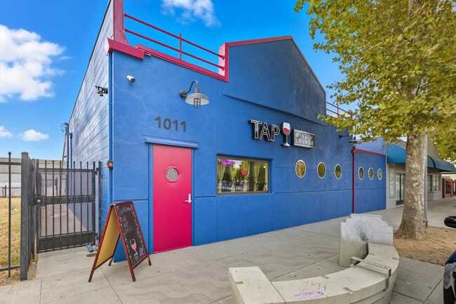
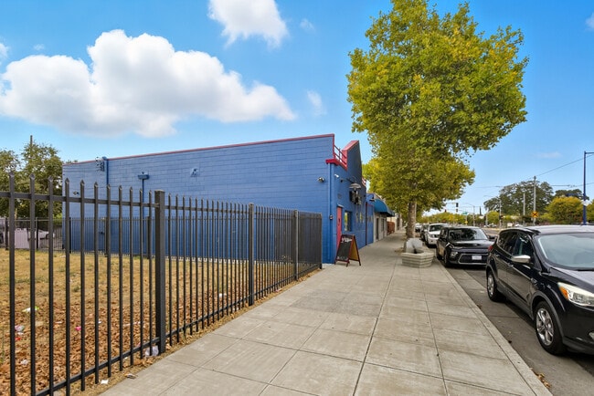
Property Record
1011 Del Paso Blvd, Sacramento, CA 95815

This Property Is For Sale
NEARBY LISTINGS FOR SALE OR LEASE
Property Detail
1011 Del Paso Blvd
Sacramento-Roseville-Folsom, CA
North Sacramento Sub 9
275-0161-012
E 45 FT LOT 14 BLK 17 NORTH SACRAMENTO SUB NO 9
Bartavern
Sacramento
X
California
06067C0177J
14
2024
0.16 AC
2025
Arden/Watt/Howe
006902
Sacramento
1,719 SF
DEMOGRAPHICS near 1011 Del Paso Blvd
1 Mile
3 Mile
5 Mile
2024 Total Population
9,710
163,171
392,055
2029 Population
9,817
165,132
396,769
Pop Growth 2024-2029
+ 1.10%
+ 1.20%
+ 1.20%
Average Age
38
37
38
2024 Total Households
3,378
64,591
154,466
HH Growth 2024-2029
+ 1.15%
+ 1.44%
+ 1.33%
Median Household Inc
$50,739
$65,123
$68,585
Avg Household Size
2.70
2.30
2.40
2024 Avg HH Vehicles
2.00
2.00
2.00
Median Home Value
$335,642
$443,819
$472,291
Median Year Built
1958
1970
1971
Nearby Places
Map Layers
Map Styles
 Street
 Aerial
- Restaurants
- Banks
- Shops
- Fitness
- Groceries
PUBLIC TRANSPORTATION
TRANSIT/SUBWAY
Globe Avenue (Blue Line - Sacramento Regional Transit District Light Rail (The RT))
DRIVE
WALK
Distance
Globe Avenue (Blue Line - Sacramento Regional Transit District Light Rail (The RT))
0 min
1 min
0.0 mi
Arden/Del Paso (Blue Line - Sacramento Regional Transit District Light Rail (The RT))
DRIVE
WALK
Distance
Arden/Del Paso (Blue Line - Sacramento Regional Transit District Light Rail (The RT))
2 min
10 min
0.5 mi
Royal Oaks (Blue Line - Sacramento Regional Transit District Light Rail (The RT))
DRIVE
WALK
Distance
Royal Oaks (Blue Line - Sacramento Regional Transit District Light Rail (The RT))
4 min
20 min
1.0 mi
COMMUTER RAIL
DRIVE
WALK
Distance
5 min
2.8 mi
AIRPORT
Sacramento International
DRIVE
WALK
Distance
Sacramento International
18 min
11.7 mi
Freight Ports
Port of Stockton
DRIVE
WALK
Distance
Port of Stockton
58 min
49.7 mi
Nearby Properties
Address
Land Use
TOTAL SIZE
Lot Size
Zoning
Address
Land Use
TOTAL SIZE
Lot Size
Zoning
1,095,507 SF
1.39 AC
H-SPD C-2-
Address
Land Use
TOTAL SIZE
Lot Size
Zoning
5.64 AC
C-3-SPD
Address
Land Use
TOTAL SIZE
Lot Size
Zoning
10.28 AC
H
Address
Land Use
TOTAL SIZE
Lot Size
Zoning
201,132 SF
28.11 AC
C-2
Address
Land Use
TOTAL SIZE
Lot Size
Zoning
487,483 SF
1.12 AC
C-3-SPD
Address
Land Use
TOTAL SIZE
Lot Size
Zoning
756,831 SF
1.39 AC
C-2-SPD
Address
Land Use
TOTAL SIZE
Lot Size
Zoning
399,626 SF
2.41 AC
C-3-SPD
Address
Land Use
TOTAL SIZE
Lot Size
Zoning
366,730 SF
0.89 AC
C-3-SPD
Address
Land Use
TOTAL SIZE
Lot Size
Zoning
200,616 SF
2.54 AC
C-2-SPD
Address
Land Use
TOTAL SIZE
Lot Size
Zoning
2.87 AC
C-2
Address
Land Use
TOTAL SIZE
Lot Size
Zoning
594,942 SF
2.39 AC
C-3-SPD
Address
Land Use
TOTAL SIZE
Lot Size
Zoning
10.49 AC
C-2
Address
Land Use
TOTAL SIZE
Lot Size
Zoning
676,447 SF
1.43 AC
C-3-SPD
Address
Land Use
TOTAL SIZE
Lot Size
Zoning
319,856 SF
12.27 AC
R-3-R-PUD
Address
Land Use
TOTAL SIZE
Lot Size
Zoning
193,521 SF
0.60 AC
C-3-SPD
Address
Land Use
TOTAL SIZE
Lot Size
Zoning
339,329 SF
6.40 AC
R-5-PUD-SP
Address
Land Use
TOTAL SIZE
Lot Size
Zoning
213,557 SF
2.33 AC
C-3-SPD
Address
Land Use
TOTAL SIZE
Lot Size
Zoning
226,731 SF
15.73 AC
OB-PUD
Address
Land Use
TOTAL SIZE
Lot Size
Zoning
0.65 AC
C-4-SPD
Address
Land Use
TOTAL SIZE
Lot Size
Zoning
467,970 SF
4.59 AC
W-F
Address
Land Use
TOTAL SIZE
Lot Size
Zoning
390,860 SF
20.17 AC
R-3-R-PUD
Address
Land Use
TOTAL SIZE
Lot Size
Zoning
410,420 SF
0.95 AC
C-3-SPD
Address
Land Use
TOTAL SIZE
Lot Size
Zoning
0.13 AC
WF
Address
Land Use
TOTAL SIZE
Lot Size
Zoning
26,712 SF
1.90 AC
R-5-PUD-SP
Address
Land Use
TOTAL SIZE
Lot Size
Zoning
26,712 SF
1.85 AC
R-5-PUD-SP
Address
Land Use
TOTAL SIZE
Lot Size
Zoning
2.88 AC
C-3-SPD
Address
Land Use
TOTAL SIZE
Lot Size
Zoning
508,916 SF
0.71 AC
C-3-SPD
Address
Land Use
TOTAL SIZE
Lot Size
Zoning
303,254 SF
10.63 AC
OB-PUD
Address
Land Use
TOTAL SIZE
Lot Size
Zoning
246,417 SF
1.19 AC
C-3-SPD
Address
Land Use
TOTAL SIZE
Lot Size
Zoning
405,074 SF
2.39 AC
C-3-SPD
The World's #1 Commercial Real Estate Marketplace
Connect with us
© 2026 CoStar Group
The information above has been obtained from sources believed reliable. While we do not doubt its accuracy we have not verified it and make no guarantee, warranty or representation about it. It is your responsibility to independently confirm its accuracy and completeness. Any projections, opinions, assumptions, or estimates used are for example only and do not represent the current or future performance of the property. The value of this transaction to you depends on tax and other factors which should be evaluated by your tax, financial, and legal advisors. You and your advisors should conduct a careful, independent investigation of the property to determine to your satisfaction the suitability of the property for your needs.