Property Record
1011 E Mission Rd, San Marcos, CA 92069


Save to a Folder
{{folder.Name}}
{{folder.ListingIds.length}} Properties
{{folder.ListingIds.length}} Property
Create a New Folder
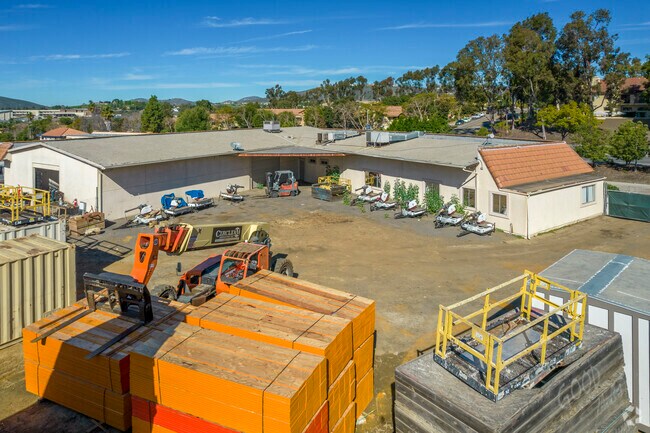
Property Detail
1011 E Mission Rd
226-071-03
BLK 21 LOT 9 (EX ST)DOC68-199559 IN TR 000806
Warehouse
San Diego
I
California
B and X Area of moderate flood hazard, usually the area between the limits of the 100-year and 500-year floods.
9
2025
2.41 AC
2026
San Marcos
020025
San Diego
5,730 SF
San Diego-Chula Vista-Carlsbad, CA
NEARBY LISTINGS FOR SALE OR LEASE
DEMOGRAPHICS near 1011 E Mission Rd
1 mile
3 mile
5 mile
2025 Total Population
13,494
95,134
237,330
2030 Population
13,522
95,563
237,450
Pop Growth 2025-2030
+ 0.21%
+ 0.45%
+ 0.05%
Average Age
42
38
39
2025 Total Households
4,799
32,118
76,264
HH Growth 2025-2030
+ 0.33%
+ 0.32%
(0.02%)
Median Household Inc
$99,307
$98,904
$96,538
Avg Household Size
2.70
2.80
3.00
2025 Avg HH Vehicles
2.00
2.00
2.00
Median Home Value
$714,893
$750,719
$788,613
Median Year Built
1980
1986
1983
Nearby Places
Map Layers
Map Styles
 Street
 Aerial
Layers
 Traffic
 Biking
Places
Listings with unknown addresses are not visible on the map
- Restaurants
- Banks
- Shops
- Fitness
- Groceries
PUBLIC TRANSPORTATION
AIRPORT
San Diego International
Drive
Walk
Distance
San Diego International
42 min
32.8 mi
Freight Ports
Port of San Diego
Drive
Walk
Distance
Port of San Diego
46 min
35.1 mi
SALE & LEASE HISTORY
LISTING DATE
SALE/LEASE

Sep 24, 2016
For Lease
May 11, 2020
For Lease
May 11, 2020
For Sale
Nearby Properties
Address
Land Use
TOTAL SIZE
Lot Size
Zoning
Address
Land Use
TOTAL SIZE
Lot Size
Zoning
9,999 SF
27.98 AC
SPA
Address
Land Use
TOTAL SIZE
Lot Size
Zoning
9,999 SF
3.78 AC
C-6
Address
Land Use
TOTAL SIZE
Lot Size
Zoning
9,999 SF
14.98 AC
R-1-10
Address
Land Use
TOTAL SIZE
Lot Size
Zoning
9,999 SF
9.77 AC
PD-R-18
Address
Land Use
TOTAL SIZE
Lot Size
Zoning
9,999 SF
15.37 AC
SPA
Address
Land Use
TOTAL SIZE
Lot Size
Zoning
9,999 SF
5.25 AC
SPA
Address
Land Use
TOTAL SIZE
Lot Size
Zoning
9,999 SF
5.37 AC
SPA
Address
Land Use
TOTAL SIZE
Lot Size
Zoning
9,999 SF
10.82 AC
SPA
Address
Land Use
TOTAL SIZE
Lot Size
Zoning
Address
Land Use
TOTAL SIZE
Lot Size
Zoning
1,656 SF
S-P
Address
Land Use
TOTAL SIZE
Lot Size
Zoning
Address
Land Use
TOTAL SIZE
Lot Size
Zoning
9,999 SF
9.88 AC
R-3-10
Address
Land Use
TOTAL SIZE
Lot Size
Zoning
9,999 SF
SPECIFIC P
Address
Land Use
TOTAL SIZE
Lot Size
Zoning
5,138 SF
C
Address
Land Use
TOTAL SIZE
Lot Size
Zoning
64 SF
1.53 AC
S-P
Address
Land Use
TOTAL SIZE
Lot Size
Zoning
1.49 AC
SPA
Address
Land Use
TOTAL SIZE
Lot Size
Zoning
9,999 SF
5.94 AC
PD-R-24
Address
Land Use
TOTAL SIZE
Lot Size
Zoning
9,461 SF
4.89 AC
SPA
Address
Land Use
TOTAL SIZE
Lot Size
Zoning
9,999 SF
10.80 AC
SPA
Address
Land Use
TOTAL SIZE
Lot Size
Zoning
9,999 SF
1.94 AC
C
Address
Land Use
TOTAL SIZE
Lot Size
Zoning
9,999 SF
8.30 AC
R-2-12
Address
Land Use
TOTAL SIZE
Lot Size
Zoning
Address
Land Use
TOTAL SIZE
Lot Size
Zoning
59,858 SF
12.12 AC
A70
Address
Land Use
TOTAL SIZE
Lot Size
Zoning
7,874 SF
8.47 AC
R-2-12
Address
Land Use
TOTAL SIZE
Lot Size
Zoning
9,999 SF
7.05 AC
R-3-18
Address
Land Use
TOTAL SIZE
Lot Size
Zoning
9,999 SF
13.99 AC
PD-C
Address
Land Use
TOTAL SIZE
Lot Size
Zoning
9,999 SF
7.06 AC
SR
Address
Land Use
TOTAL SIZE
Lot Size
Zoning
9,999 SF
6.24 AC
R-3-18
Address
Land Use
TOTAL SIZE
Lot Size
Zoning
5,713 SF
0.51 AC
C
Address
Land Use
TOTAL SIZE
Lot Size
Zoning
9,999 SF
10.69 AC
R-3-10
The World's #1 Commercial Real Estate Marketplace
Connect with us
© 2026 CoStar Group
The information above has been obtained from sources believed reliable. While we do not doubt its accuracy we have not verified it and make no guarantee, warranty or representation about it. It is your responsibility to independently confirm its accuracy and completeness. Any projections, opinions, assumptions, or estimates used are for example only and do not represent the current or future performance of the property. The value of this transaction to you depends on tax and other factors which should be evaluated by your tax, financial, and legal advisors. You and your advisors should conduct a careful, independent investigation of the property to determine to your satisfaction the suitability of the property for your needs.