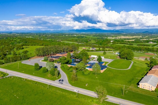
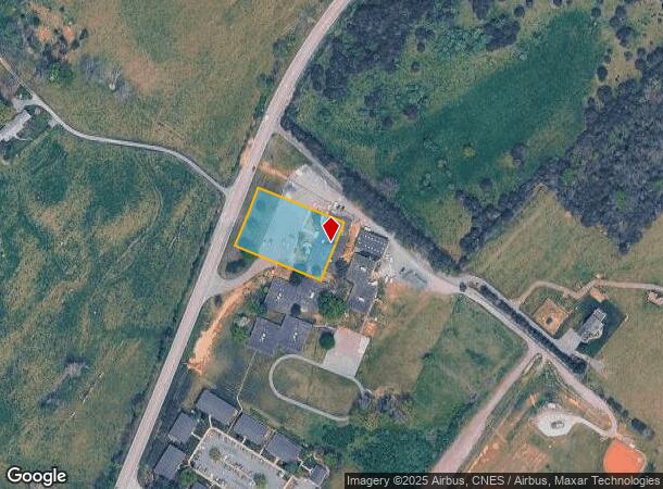
Property Record
1011 Lee Hwy, Verona, VA 24482
NEARBY LISTINGS FOR SALE OR LEASE
-
-
View all Verona listings for sale on LoopNet.com
Property Detail
1011 Lee Hwy
Staunton-Waynesboro, VA
Mary See Sub Div
036C-1-4
36C-(1)-4 & 1A,2,3,5,6&7 MARY SEE SUB DIV LOT 4
University
Augusta
X
Virginia
51015C0351D
4
0
18.20 AC
2025
Staunton & Harrisonburg
070701
Other Market Areas
10,845 SF
DEMOGRAPHICS near 1011 Lee Hwy
1 Mile
3 Mile
5 Mile
2024 Total Population
640
5,901
11,720
2029 Population
637
5,949
11,855
Pop Growth 2024-2029
(0.47%)
+ 0.81%
+ 1.15%
Average Age
45
43
44
2024 Total Households
262
2,135
4,507
HH Growth 2024-2029
(0.38%)
+ 0.66%
+ 1.13%
Median Household Inc
$87,000
$65,767
$80,652
Avg Household Size
2.30
2.30
2.40
2024 Avg HH Vehicles
3.00
2.00
2.00
Median Home Value
$207,576
$207,325
$271,367
Median Year Built
1983
1976
1976
Nearby Places
Map Layers
Map Styles
 Street
 Aerial
- Restaurants
- Banks
- Shops
- Fitness
- Groceries
PUBLIC TRANSPORTATION
COMMUTER RAIL
Staunton Amtrak Station (Cardinal - Amtrak)
DRIVE
WALK
Distance
Staunton Amtrak Station (Cardinal - Amtrak)
11 min
7.0 mi
Freight Ports
Virginia Port Authority - Richmond
DRIVE
WALK
Distance
Virginia Port Authority - Richmond
139 min
118.9 mi
SALE & LEASE HISTORY
LISTING DATE
SALE/LEASE

May 31, 2019
For Sale
Nearby Properties
Address
Land Use
TOTAL SIZE
Lot Size
Zoning
Address
Land Use
TOTAL SIZE
Lot Size
Zoning
262,369 SF
24.50 AC
GENERAL BU
Address
Land Use
TOTAL SIZE
Lot Size
Zoning
132,832 SF
50.44 AC
GENERAL BU
Address
Land Use
TOTAL SIZE
Lot Size
Zoning
218,331 SF
40 AC
PLANNED CO
Address
Land Use
TOTAL SIZE
Lot Size
Zoning
181,835 SF
29.88 AC
GENERAL AG
Address
Land Use
TOTAL SIZE
Lot Size
Zoning
4,232 SF
12.56 AC
GENERAL IN
Address
Land Use
TOTAL SIZE
Lot Size
Zoning
87,553 SF
21.95 AC
GENERAL AG
Address
Land Use
TOTAL SIZE
Lot Size
Zoning
515,766 SF
81.76 AC
GENERAL IN
Address
Land Use
TOTAL SIZE
Lot Size
Zoning
98,301 SF
19.64 AC
GENERAL AG
Address
Land Use
TOTAL SIZE
Lot Size
Zoning
38,772 SF
8.58 AC
GENERAL BU
Address
Land Use
TOTAL SIZE
Lot Size
Zoning
303,307 SF
146.93 AC
GENERAL IN
Address
Land Use
TOTAL SIZE
Lot Size
Zoning
174,284 SF
10.35 AC
GENERAL BU
Address
Land Use
TOTAL SIZE
Lot Size
Zoning
111,992 SF
7.13 AC
PLANNED CO
Address
Land Use
TOTAL SIZE
Lot Size
Zoning
43,502 SF
15.61 AC
I2
Address
Land Use
TOTAL SIZE
Lot Size
Zoning
20,858 SF
12.73 AC
GENERAL BU
Address
Land Use
TOTAL SIZE
Lot Size
Zoning
9,097 SF
5.18 AC
MULTI-FAMI
Address
Land Use
TOTAL SIZE
Lot Size
Zoning
56,375 SF
4.69 AC
PLANNED CO
Address
Land Use
TOTAL SIZE
Lot Size
Zoning
10,845 SF
18.20 AC
SINGLE FAM
Address
Land Use
TOTAL SIZE
Lot Size
Zoning
85,840 SF
22.95 AC
GENERAL IN
Address
Land Use
TOTAL SIZE
Lot Size
Zoning
1,800 SF
10.71 AC
GENERAL BU
Address
Land Use
TOTAL SIZE
Lot Size
Zoning
24,078 SF
10 AC
GENERAL AG
Address
Land Use
TOTAL SIZE
Lot Size
Zoning
11,146 SF
5.54 AC
PLANNED CO
Address
Land Use
TOTAL SIZE
Lot Size
Zoning
53,694 SF
4.71 AC
GENERAL BU
Address
Land Use
TOTAL SIZE
Lot Size
Zoning
37,590 SF
7.41 AC
GENERAL BU
Address
Land Use
TOTAL SIZE
Lot Size
Zoning
132,153 SF
7 AC
I2
Address
Land Use
TOTAL SIZE
Lot Size
Zoning
8,000 SF
5 AC
I2
Address
Land Use
TOTAL SIZE
Lot Size
Zoning
2,831 SF
149.67 AC
PLANNED CO
Address
Land Use
TOTAL SIZE
Lot Size
Zoning
44,175 SF
3.38 AC
GENERAL BU
Address
Land Use
TOTAL SIZE
Lot Size
Zoning
3,692 SF
76.26 AC
GENERAL AG
Address
Land Use
TOTAL SIZE
Lot Size
Zoning
44,992 SF
6.11 AC
GENERAL BU
Address
Land Use
TOTAL SIZE
Lot Size
Zoning
11,951 SF
3.69 AC
MULTI-FAMI
The World's #1 Commercial Real Estate Marketplace
Connect with us
© 2026 CoStar Group
The information above has been obtained from sources believed reliable. While we do not doubt its accuracy we have not verified it and make no guarantee, warranty or representation about it. It is your responsibility to independently confirm its accuracy and completeness. Any projections, opinions, assumptions, or estimates used are for example only and do not represent the current or future performance of the property. The value of this transaction to you depends on tax and other factors which should be evaluated by your tax, financial, and legal advisors. You and your advisors should conduct a careful, independent investigation of the property to determine to your satisfaction the suitability of the property for your needs.