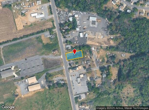
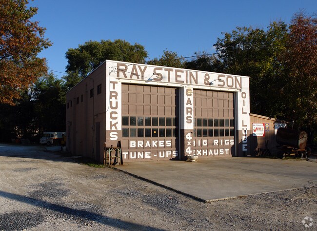
Property Record
1011 N Delsea Dr, Clayton, NJ 08312

NEARBY LISTINGS FOR SALE OR LEASE
Property Detail
1011 N Delsea Dr
01-01701-0000-00030
Gloucester
Vacantlandnec
New Jersey
X
30
34015C0211E
0.39 AC
2024
Gloucester County
2025
Philadelphia
501501
Philadelphia-Camden-Wilmington, PA-NJ-DE-MD
DEMOGRAPHICS near 1011 N Delsea Dr
1 Mile
3 Mile
5 Mile
2024 Total Population
9,193
80,351
257,215
2029 Population
9,507
81,941
258,182
Pop Growth 2024-2029
+ 3.42%
+ 1.98%
+ 0.38%
Average Age
41
41
40
2024 Total Households
3,870
32,087
102,594
HH Growth 2024-2029
+ 3.33%
+ 1.97%
+ 0.31%
Median Household Inc
$55,858
$73,024
$74,692
Avg Household Size
2.30
2.50
2.50
2024 Avg HH Vehicles
1.00
2.00
2.00
Median Home Value
$170,631
$193,413
$233,356
Median Year Built
1960
1958
1956
Nearby Places
Map Layers
Map Styles
 Street
 Aerial
- Restaurants
- Banks
- Shops
- Fitness
- Groceries
PUBLIC TRANSPORTATION
AIRPORT
Philadelphia International
DRIVE
WALK
Distance
Philadelphia International
42 min
30.2 mi
Atlantic City International
DRIVE
WALK
Distance
Atlantic City International
60 min
38.2 mi
SALE & LEASE HISTORY
LISTING DATE
SALE/LEASE

Sep 23, 2016
For Sale
Feb 13, 2017
For Lease
Nearby Properties
Address
Land Use
TOTAL SIZE
Lot Size
Zoning
Address
Land Use
TOTAL SIZE
Lot Size
Zoning
3.34 AC
R3
Address
Land Use
TOTAL SIZE
Lot Size
Zoning
4.41 AC
Address
Land Use
TOTAL SIZE
Lot Size
Zoning
Address
Land Use
TOTAL SIZE
Lot Size
Zoning
Address
Land Use
TOTAL SIZE
Lot Size
Zoning
46.38 AC
P
Address
Land Use
TOTAL SIZE
Lot Size
Zoning
Address
Land Use
TOTAL SIZE
Lot Size
Zoning
Address
Land Use
TOTAL SIZE
Lot Size
Zoning
26.35 AC
R4
Address
Land Use
TOTAL SIZE
Lot Size
Zoning
1.77 AC
Address
Land Use
TOTAL SIZE
Lot Size
Zoning
23.80 AC
R-B
Address
Land Use
TOTAL SIZE
Lot Size
Zoning
Address
Land Use
TOTAL SIZE
Lot Size
Zoning
14.57 AC
P
Address
Land Use
TOTAL SIZE
Lot Size
Zoning
37.40 AC
CF/I
Address
Land Use
TOTAL SIZE
Lot Size
Zoning
2.68 AC
P
Address
Land Use
TOTAL SIZE
Lot Size
Zoning
17.02 AC
PA
Address
Land Use
TOTAL SIZE
Lot Size
Zoning
7.57 AC
P
Address
Land Use
TOTAL SIZE
Lot Size
Zoning
Address
Land Use
TOTAL SIZE
Lot Size
Zoning
21.14 AC
CF/I
Address
Land Use
TOTAL SIZE
Lot Size
Zoning
0.91 AC
P
Address
Land Use
TOTAL SIZE
Lot Size
Zoning
Address
Land Use
TOTAL SIZE
Lot Size
Zoning
76.57 AC
I
Address
Land Use
TOTAL SIZE
Lot Size
Zoning
15.47 AC
C5
Address
Land Use
TOTAL SIZE
Lot Size
Zoning
4.41 AC
Address
Land Use
TOTAL SIZE
Lot Size
Zoning
3.23 AC
P
Address
Land Use
TOTAL SIZE
Lot Size
Zoning
39.31 AC
I2
Address
Land Use
TOTAL SIZE
Lot Size
Zoning
55.88 AC
APA
Address
Land Use
TOTAL SIZE
Lot Size
Zoning
3.17 AC
Address
Land Use
TOTAL SIZE
Lot Size
Zoning
17.78 AC
I2
Address
Land Use
TOTAL SIZE
Lot Size
Zoning
9.49 AC
P
Address
Land Use
TOTAL SIZE
Lot Size
Zoning
3,750 SF
5.55 AC
C3
The World's #1 Commercial Real Estate Marketplace
Connect with us
© 2025 CoStar Group
The information above has been obtained from sources believed reliable. While we do not doubt its accuracy we have not verified it and make no guarantee, warranty or representation about it. It is your responsibility to independently confirm its accuracy and completeness. Any projections, opinions, assumptions, or estimates used are for example only and do not represent the current or future performance of the property. The value of this transaction to you depends on tax and other factors which should be evaluated by your tax, financial, and legal advisors. You and your advisors should conduct a careful, independent investigation of the property to determine to your satisfaction the suitability of the property for your needs.