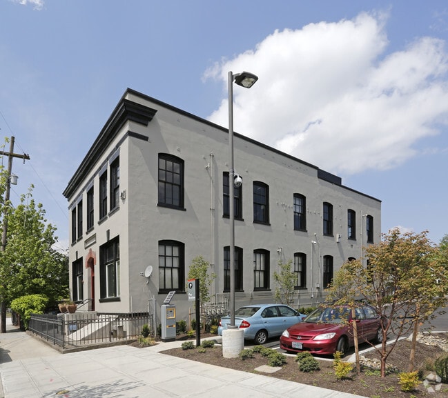
Property Record
1011 N Killingsworth St, Portland, OR 97217

Property Detail
1011 N Killingsworth St
R226134
NORTH ALBINA, BLOCK 5, LOT 8
Multifamilydwelling
Multnomah
CI2
Oregon
B and X Area of moderate flood hazard, usually the area between the limits of the 100-year and 500-year floods.
8
2025
0.12 AC
2025
Humboldt
003803
Portland
3,592 SF
Portland-Vancouver-Hillsboro, OR-WA
NEARBY LISTINGS FOR SALE OR LEASE
DEMOGRAPHICS near 1011 N Killingsworth St
1 mile
3 mile
5 mile
2025 Total Population
29,505
163,269
336,336
2030 Population
29,637
162,606
335,048
Pop Growth 2025-2030
+ 0.45%
(0.41%)
(0.38%)
Average Age
39
40
41
2025 Total Households
13,273
78,061
160,764
HH Growth 2025-2030
+ 0.24%
(0.41%)
(0.35%)
Median Household Inc
$102,536
$92,859
$90,751
Avg Household Size
2.10
2.00
2.00
2025 Avg HH Vehicles
2.00
1.00
1.00
Median Home Value
$684,112
$705,186
$692,309
Median Year Built
1949
1962
1962
Nearby Places
Map Layers
Map Styles
 Street
 Aerial
Layers
 Traffic
 Biking
Places
Listings with unknown addresses are not visible on the map
- Restaurants
- Banks
- Shops
- Fitness
- Groceries
PUBLIC TRANSPORTATION
TRANSIT/SUBWAY
N Killingsworth (MAX Yellow Line - Tri-County Metropolitan Transportation District of Oregon Rail (TriMet Rail))
Drive
Walk
Distance
N Killingsworth (MAX Yellow Line - Tri-County Metropolitan Transportation District of Oregon Rail (TriMet Rail))
1 min
4 min
0.2 mi
Rosa Parks (MAX Yellow Line - Tri-County Metropolitan Transportation District of Oregon Rail (TriMet Rail))
Drive
Walk
Distance
Rosa Parks (MAX Yellow Line - Tri-County Metropolitan Transportation District of Oregon Rail (TriMet Rail))
2 min
13 min
0.7 mi
N Prescott (MAX Yellow Line - Tri-County Metropolitan Transportation District of Oregon Rail (TriMet Rail))
Drive
Walk
Distance
N Prescott (MAX Yellow Line - Tri-County Metropolitan Transportation District of Oregon Rail (TriMet Rail))
3 min
14 min
0.7 mi
COMMUTER RAIL
Portland (Amtrak Cascades - Amtrak, Coast Starlight - Amtrak, Empire Builder - Amtrak)
Drive
Walk
Distance
Portland (Amtrak Cascades - Amtrak, Coast Starlight - Amtrak, Empire Builder - Amtrak)
7 min
3.0 mi
Vancouver (Amtrak Cascades - Amtrak, Coast Starlight - Amtrak, Empire Builder - Amtrak)
Drive
Walk
Distance
Vancouver (Amtrak Cascades - Amtrak, Coast Starlight - Amtrak, Empire Builder - Amtrak)
13 min
6.2 mi
AIRPORT
Portland International
Drive
Walk
Distance
Portland International
19 min
8.3 mi
Freight Ports
Port of Portland
Drive
Walk
Distance
Port of Portland
7 min
3.7 mi
SALE & LEASE HISTORY
LISTING DATE
SALE/LEASE

Nov 03, 2022
For Sale
Nearby Properties
Address
Land Use
TOTAL SIZE
Lot Size
Zoning
Address
Land Use
TOTAL SIZE
Lot Size
Zoning
395,815 SF
2.66 AC
IRD
Address
Land Use
TOTAL SIZE
Lot Size
Zoning
627,500 SF
16.60 AC
CX
Address
Land Use
TOTAL SIZE
Lot Size
Zoning
882,480 SF
80.73 AC
CI1
Address
Land Use
TOTAL SIZE
Lot Size
Zoning
326,547 SF
2.42 AC
RH
Address
Land Use
TOTAL SIZE
Lot Size
Zoning
417,324 SF
0.68 AC
CX
Address
Land Use
TOTAL SIZE
Lot Size
Zoning
257,700 SF
2.89 AC
EX
Address
Land Use
TOTAL SIZE
Lot Size
Zoning
178,785 SF
10.20 AC
R5
Address
Land Use
TOTAL SIZE
Lot Size
Zoning
128,500 SF
6.95 AC
OS
Address
Land Use
TOTAL SIZE
Lot Size
Zoning
7.78 AC
EX
Address
Land Use
TOTAL SIZE
Lot Size
Zoning
Address
Land Use
TOTAL SIZE
Lot Size
Zoning
Address
Land Use
TOTAL SIZE
Lot Size
Zoning
426,742 SF
0.53 AC
RXD
Address
Land Use
TOTAL SIZE
Lot Size
Zoning
243,371 SF
0.67 AC
CI2
Address
Land Use
TOTAL SIZE
Lot Size
Zoning
645,294 SF
5.64 AC
CO2D
Address
Land Use
TOTAL SIZE
Lot Size
Zoning
247,520 SF
7.74 AC
CX
Address
Land Use
TOTAL SIZE
Lot Size
Zoning
456,760 SF
0.53 AC
EX
Address
Land Use
TOTAL SIZE
Lot Size
Zoning
193,898 SF
2.50 AC
IRD
Address
Land Use
TOTAL SIZE
Lot Size
Zoning
134,398 SF
3.17 AC
CG
Address
Land Use
TOTAL SIZE
Lot Size
Zoning
1,660,710 SF
110.33 AC
IG2
Address
Land Use
TOTAL SIZE
Lot Size
Zoning
354,677 SF
0.79 AC
CX
Address
Land Use
TOTAL SIZE
Lot Size
Zoning
2,218,439 SF
21.88 AC
CX
Address
Land Use
TOTAL SIZE
Lot Size
Zoning
265,110 SF
1.32 AC
EX
Address
Land Use
TOTAL SIZE
Lot Size
Zoning
537,280 SF
NULL
Address
Land Use
TOTAL SIZE
Lot Size
Zoning
265,300 SF
0.92 AC
EX
Address
Land Use
TOTAL SIZE
Lot Size
Zoning
85,000 SF
1.65 AC
CI2
Address
Land Use
TOTAL SIZE
Lot Size
Zoning
318,562 SF
33.59 AC
CI1
Address
Land Use
TOTAL SIZE
Lot Size
Zoning
360,053 SF
0.71 AC
EXD
Address
Land Use
TOTAL SIZE
Lot Size
Zoning
222,942 SF
0.80 AC
EX
Address
Land Use
TOTAL SIZE
Lot Size
Zoning
97,000 SF
NULL
Address
Land Use
TOTAL SIZE
Lot Size
Zoning
308,619 SF
0.92 AC
EX
The World's #1 Commercial Real Estate Marketplace
Connect with us
© 2026 CoStar Group
The information above has been obtained from sources believed reliable. While we do not doubt its accuracy we have not verified it and make no guarantee, warranty or representation about it. It is your responsibility to independently confirm its accuracy and completeness. Any projections, opinions, assumptions, or estimates used are for example only and do not represent the current or future performance of the property. The value of this transaction to you depends on tax and other factors which should be evaluated by your tax, financial, and legal advisors. You and your advisors should conduct a careful, independent investigation of the property to determine to your satisfaction the suitability of the property for your needs.