Property Record
1011 Ocean Hwy, Pocomoke City, MD 21851


NEARBY LISTINGS FOR SALE OR LEASE
-
-
View all Pocomoke City listings for sale on LoopNet.com
Property Detail
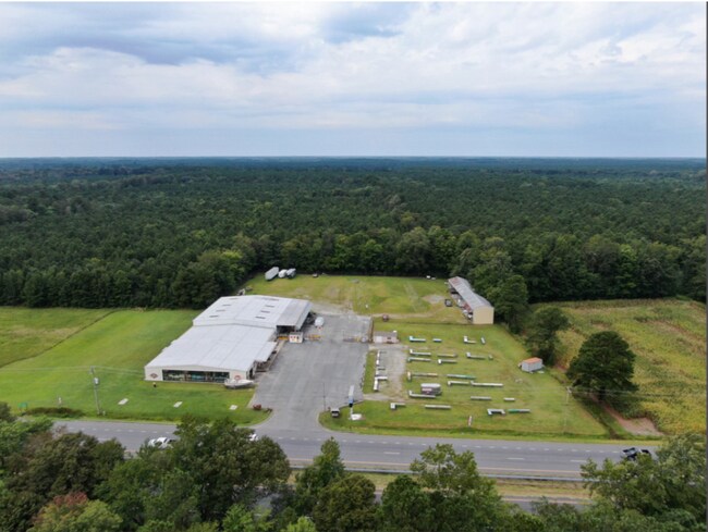
1011 Ocean Hwy
01-010352
4.232 ACS WEST SIDE R-113 S OF POCOMOKE
Warehouse
Worcester
X
Maryland
24047C0345H
4.23 AC
2025
Chesapeake Bay/Salisbury
2025
Other Market Areas
951500
Salisbury, MD-DE
8,190 SF
DEMOGRAPHICS near 1011 Ocean Hwy
1 Mile
3 Mile
5 Mile
2024 Total Population
41
2,711
4,825
2029 Population
40
2,564
4,598
Pop Growth 2024-2029
(2.44%)
(5.42%)
(4.70%)
Average Age
43
37
39
2024 Total Households
16
978
1,761
HH Growth 2024-2029
(12.50%)
(9.00%)
(7.67%)
Median Household Inc
$59,999
$50,755
$51,418
Avg Household Size
2.30
2.50
2.50
2024 Avg HH Vehicles
3.00
2.00
2.00
Median Home Value
$140,000
$130,769
$141,894
Median Year Built
1978
1969
1966
Nearby Places
Map Layers
Map Styles
 Street
 Aerial
- Restaurants
- Banks
- Shops
- Fitness
- Groceries
PUBLIC TRANSPORTATION
AIRPORT
Salisbury-Ocean City Wicomico Regional
DRIVE
WALK
Distance
Salisbury-Ocean City Wicomico Regional
48 min
30.6 mi
SALE & LEASE HISTORY
LISTING DATE
SALE/LEASE

Feb 09, 2022
For Sale
Aug 16, 2017
For Lease
Nearby Properties
Address
Land Use
TOTAL SIZE
Lot Size
Zoning
Address
Land Use
TOTAL SIZE
Lot Size
Zoning
124,620 SF
22.02 AC
R-2
Address
Land Use
TOTAL SIZE
Lot Size
Zoning
151,642 SF
17.81 AC
B-2
Address
Land Use
TOTAL SIZE
Lot Size
Zoning
88,152 SF
21.28 AC
R-3
Address
Land Use
TOTAL SIZE
Lot Size
Zoning
21,224 SF
3.37 AC
B-2
Address
Land Use
TOTAL SIZE
Lot Size
Zoning
27,000 SF
4.28 AC
B-2
Address
Land Use
TOTAL SIZE
Lot Size
Zoning
47,120 SF
7.24 AC
B-2
Address
Land Use
TOTAL SIZE
Lot Size
Zoning
48,750 SF
4.62 AC
M-1
Address
Land Use
TOTAL SIZE
Lot Size
Zoning
3,060 SF
4 AC
R-2
Address
Land Use
TOTAL SIZE
Lot Size
Zoning
51,614 SF
2.06 AC
R-2
Address
Land Use
TOTAL SIZE
Lot Size
Zoning
558 SF
195 AC
M-1
Address
Land Use
TOTAL SIZE
Lot Size
Zoning
40,216 SF
3.97 AC
R-3
Address
Land Use
TOTAL SIZE
Lot Size
Zoning
20,000 SF
7.94 AC
M-1
Address
Land Use
TOTAL SIZE
Lot Size
Zoning
25.29 AC
Address
Land Use
TOTAL SIZE
Lot Size
Zoning
6,600 SF
8.60 AC
B-2
Address
Land Use
TOTAL SIZE
Lot Size
Zoning
4,326 SF
3.26 AC
R-3
Address
Land Use
TOTAL SIZE
Lot Size
Zoning
3,000 SF
5.39 AC
B-2
Address
Land Use
TOTAL SIZE
Lot Size
Zoning
18,117 SF
5.50 AC
C2
Address
Land Use
TOTAL SIZE
Lot Size
Zoning
8,418 SF
3.86 AC
B-2
Address
Land Use
TOTAL SIZE
Lot Size
Zoning
3,600 SF
2 AC
C2
Address
Land Use
TOTAL SIZE
Lot Size
Zoning
12,352 SF
2.04 AC
R-2
Address
Land Use
TOTAL SIZE
Lot Size
Zoning
36,288 SF
2.88 AC
R-3
Address
Land Use
TOTAL SIZE
Lot Size
Zoning
30,321 SF
19.90 AC
B-2
Address
Land Use
TOTAL SIZE
Lot Size
Zoning
1,353 SF
3.57 AC
B-2
Address
Land Use
TOTAL SIZE
Lot Size
Zoning
52.75 AC
A-1
Address
Land Use
TOTAL SIZE
Lot Size
Zoning
4,928 SF
4.76 AC
Address
Land Use
TOTAL SIZE
Lot Size
Zoning
28,675 SF
4.01 AC
M-1
Address
Land Use
TOTAL SIZE
Lot Size
Zoning
144.63 AC
Address
Land Use
TOTAL SIZE
Lot Size
Zoning
10,802 SF
9.31 AC
C2
Address
Land Use
TOTAL SIZE
Lot Size
Zoning
7,272 SF
4.41 AC
R-2
Address
Land Use
TOTAL SIZE
Lot Size
Zoning
11,820 SF
4 AC
M-1
The World's #1 Commercial Real Estate Marketplace
Connect with us
© 2026 CoStar Group
The information above has been obtained from sources believed reliable. While we do not doubt its accuracy we have not verified it and make no guarantee, warranty or representation about it. It is your responsibility to independently confirm its accuracy and completeness. Any projections, opinions, assumptions, or estimates used are for example only and do not represent the current or future performance of the property. The value of this transaction to you depends on tax and other factors which should be evaluated by your tax, financial, and legal advisors. You and your advisors should conduct a careful, independent investigation of the property to determine to your satisfaction the suitability of the property for your needs.