Property Record
1011 Queens Bridge Way, Griffin, GA 30223
NEARBY LISTINGS FOR SALE OR LEASE
Property Detail
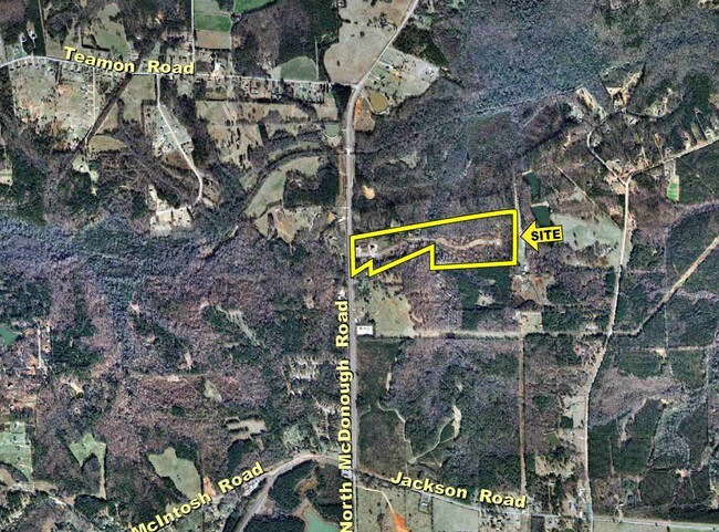
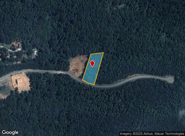
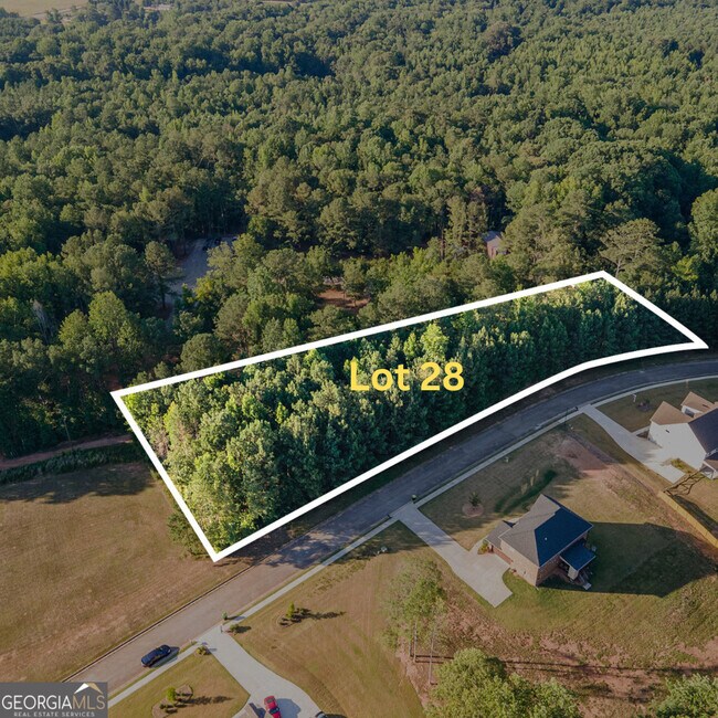
1011 Queens Bridge Way
Atlanta-Sandy Springs-Roswell, GA
Parliament Place
204-01-048
LOT 26 1.002 AC PB 25/149-151
Residentialacreage
Spalding
X
Georgia
13255C0095E
26
2024
1 AC
2024
Spalding County
160201
Atlanta
DEMOGRAPHICS near 1011 Queens Bridge Way
1 Mile
3 Mile
5 Mile
2024 Total Population
494
8,570
25,381
2029 Population
526
9,202
27,499
Pop Growth 2024-2029
+ 6.48%
+ 7.37%
+ 8.34%
Average Age
51
43
42
2024 Total Households
214
3,134
9,393
HH Growth 2024-2029
+ 6.54%
+ 7.15%
+ 8.14%
Median Household Inc
$70,277
$84,973
$74,250
Avg Household Size
2.30
2.70
2.70
2024 Avg HH Vehicles
2.00
2.00
2.00
Median Home Value
$254,430
$267,174
$241,041
Median Year Built
2000
2001
2002
Nearby Places
Map Layers
Map Styles
 Street
 Aerial
- Restaurants
- Banks
- Shops
- Fitness
- Groceries
PUBLIC TRANSPORTATION
AIRPORT
Hartsfield - Jackson Atlanta International
DRIVE
WALK
Distance
Hartsfield - Jackson Atlanta International
44 min
33.1 mi
Freight Ports
Georgia Ports - Savannah
DRIVE
WALK
Distance
Georgia Ports - Savannah
241 min
214.1 mi
SALE & LEASE HISTORY
LISTING DATE
SALE/LEASE

Nov 17, 2016
For Sale
Nov 17, 2016
For Sale
Mar 15, 2017
For Sale
Mar 07, 2017
For Sale
Jun 17, 2024
For Sale
Nearby Properties
Address
Land Use
TOTAL SIZE
Lot Size
Zoning
Address
Land Use
TOTAL SIZE
Lot Size
Zoning
6,720 SF
1,081.34 AC
Address
Land Use
TOTAL SIZE
Lot Size
Zoning
16,698 SF
34.19 AC
AR1
Address
Land Use
TOTAL SIZE
Lot Size
Zoning
23.64 AC
R2
Address
Land Use
TOTAL SIZE
Lot Size
Zoning
279.69 AC
R1
Address
Land Use
TOTAL SIZE
Lot Size
Zoning
92.40 AC
R2
Address
Land Use
TOTAL SIZE
Lot Size
Zoning
6,640 SF
2.93 AC
C1
Address
Land Use
TOTAL SIZE
Lot Size
Zoning
64.01 AC
PDD
Address
Land Use
TOTAL SIZE
Lot Size
Zoning
7,000 SF
2 AC
C1
Address
Land Use
TOTAL SIZE
Lot Size
Zoning
9,360 SF
2 AC
C-1
Address
Land Use
TOTAL SIZE
Lot Size
Zoning
16,817 SF
155.32 AC
C2
Address
Land Use
TOTAL SIZE
Lot Size
Zoning
4,790 SF
1.39 AC
C
Address
Land Use
TOTAL SIZE
Lot Size
Zoning
466.19 AC
R2/AR1
Address
Land Use
TOTAL SIZE
Lot Size
Zoning
10,733 SF
0.40 AC
C
Address
Land Use
TOTAL SIZE
Lot Size
Zoning
2.90 AC
AR1
Address
Land Use
TOTAL SIZE
Lot Size
Zoning
99.95 AC
R2
Address
Land Use
TOTAL SIZE
Lot Size
Zoning
167.93 AC
R2
Address
Land Use
TOTAL SIZE
Lot Size
Zoning
600 SF
25.53 AC
R2/AR1
Address
Land Use
TOTAL SIZE
Lot Size
Zoning
2,328 SF
43.67 AC
AT
Address
Land Use
TOTAL SIZE
Lot Size
Zoning
200.93 AC
AR1
Address
Land Use
TOTAL SIZE
Lot Size
Zoning
2,760 SF
1.18 AC
C1
Address
Land Use
TOTAL SIZE
Lot Size
Zoning
3,150 SF
1.74 AC
R2
Address
Land Use
TOTAL SIZE
Lot Size
Zoning
153.27 AC
R2
Address
Land Use
TOTAL SIZE
Lot Size
Zoning
2,160 SF
1.31 AC
C1
Address
Land Use
TOTAL SIZE
Lot Size
Zoning
20 AC
C1
Address
Land Use
TOTAL SIZE
Lot Size
Zoning
172.32 AC
AR1/R2
Address
Land Use
TOTAL SIZE
Lot Size
Zoning
4,676 SF
3 AC
R2/AR1
Address
Land Use
TOTAL SIZE
Lot Size
Zoning
117.16 AC
AR1/R2
Address
Land Use
TOTAL SIZE
Lot Size
Zoning
37.41 AC
PDD
Address
Land Use
TOTAL SIZE
Lot Size
Zoning
156.98 AC
AR1/R2
The World's #1 Commercial Real Estate Marketplace
Connect with us
© 2025 CoStar Group
The information above has been obtained from sources believed reliable. While we do not doubt its accuracy we have not verified it and make no guarantee, warranty or representation about it. It is your responsibility to independently confirm its accuracy and completeness. Any projections, opinions, assumptions, or estimates used are for example only and do not represent the current or future performance of the property. The value of this transaction to you depends on tax and other factors which should be evaluated by your tax, financial, and legal advisors. You and your advisors should conduct a careful, independent investigation of the property to determine to your satisfaction the suitability of the property for your needs.