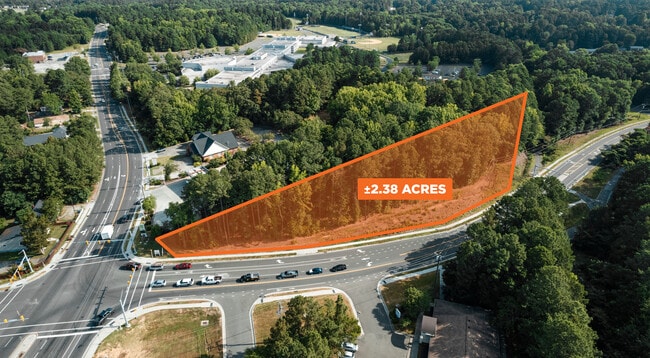
Property Record
1011 Riddle Rd, Durham, NC 27713


Current Lease Availabilities
Property Detail
1011 Riddle Rd
133904
PROP-FOWLER M M PL:207-139
Timberlandforesttreesagricultural
DURHAM
CN
North Carolina
B and X Area of moderate flood hazard, usually the area between the limits of the 100-year and 500-year floods.
2.38 AC
2025
South Durham
2025
Raleigh/Durham
002022
Durham-Chapel Hill, NC
NEARBY LISTINGS FOR SALE OR LEASE
DEMOGRAPHICS near 1011 Riddle Rd
1 mile
3 mile
5 mile
2025 Total Population
8,959
82,614
198,090
2030 Population
9,514
87,912
210,510
Pop Growth 2025-2030
+ 6.19%
+ 6.41%
+ 6.27%
Average Age
38
37
37
2025 Total Households
3,781
33,905
83,636
HH Growth 2025-2030
+ 6.40%
+ 6.67%
+ 6.63%
Median Household Inc
$51,926
$74,574
$78,488
Avg Household Size
2.30
2.30
2.20
2025 Avg HH Vehicles
2.00
2.00
2.00
Median Home Value
$395,331
$408,329
$434,596
Median Year Built
1994
1991
1992
Nearby Places
Map Layers
Map Styles
 Street
 Aerial
Transit
 Traffic
 Biking
Places
Listings with unknown addresses are not visible on the map
- Restaurants
- Banks
- Shops
- Fitness
- Groceries
PUBLIC TRANSPORTATION
COMMUTER RAIL
Drive
Walk
Distance
10 min
4.5 mi
AIRPORT
Raleigh-Durham International
Drive
Walk
Distance
Raleigh-Durham International
19 min
11.6 mi
Nearby Properties
Address
Land Use
TOTAL SIZE
Lot Size
Zoning
Address
Land Use
TOTAL SIZE
Lot Size
Zoning
839,237 SF
9.84 AC
DD-C
Address
Land Use
TOTAL SIZE
Lot Size
Zoning
875,384 SF
111.74 AC
SRP
Address
Land Use
TOTAL SIZE
Lot Size
Zoning
1,080,486 SF
61.68 AC
SRP
Address
Land Use
TOTAL SIZE
Lot Size
Zoning
677,504 SF
60.32 AC
SRP
Address
Land Use
TOTAL SIZE
Lot Size
Zoning
29.13 AC
CG(D)
Address
Land Use
TOTAL SIZE
Lot Size
Zoning
310,825 SF
3.20 AC
DD-C
Address
Land Use
TOTAL SIZE
Lot Size
Zoning
3.38 AC
DD-C
Address
Land Use
TOTAL SIZE
Lot Size
Zoning
171,375 SF
3.80 AC
DD-C
Address
Land Use
TOTAL SIZE
Lot Size
Zoning
35.03 AC
RS-M(D)
Address
Land Use
TOTAL SIZE
Lot Size
Zoning
478,037 SF
4.51 AC
DD-C
Address
Land Use
TOTAL SIZE
Lot Size
Zoning
230,275 SF
2.12 AC
DD-C
Address
Land Use
TOTAL SIZE
Lot Size
Zoning
2,922 SF
30.57 AC
PDR 4.840
Address
Land Use
TOTAL SIZE
Lot Size
Zoning
265,592 SF
2.04 AC
DD-C
Address
Land Use
TOTAL SIZE
Lot Size
Zoning
23,889 SF
50.95 AC
OI
Address
Land Use
TOTAL SIZE
Lot Size
Zoning
262,593 SF
2.73 AC
DD-C
Address
Land Use
TOTAL SIZE
Lot Size
Zoning
10,143 SF
46.78 AC
PDR 5.940
Address
Land Use
TOTAL SIZE
Lot Size
Zoning
7,241 SF
25.34 AC
PDR 5.370
Address
Land Use
TOTAL SIZE
Lot Size
Zoning
410,000 SF
31.41 AC
IL
Address
Land Use
TOTAL SIZE
Lot Size
Zoning
8,199 SF
28.28 AC
PDR 12.000
Address
Land Use
TOTAL SIZE
Lot Size
Zoning
555,485 SF
34.84 AC
SRP
Address
Land Use
TOTAL SIZE
Lot Size
Zoning
144,812 SF
1.44 AC
DD-C
Address
Land Use
TOTAL SIZE
Lot Size
Zoning
10,572 SF
27.56 AC
RS-M(D)
Address
Land Use
TOTAL SIZE
Lot Size
Zoning
5,184 SF
42.28 AC
OI(D)
Address
Land Use
TOTAL SIZE
Lot Size
Zoning
12,864 SF
24.27 AC
RS-M
Address
Land Use
TOTAL SIZE
Lot Size
Zoning
260,000 SF
35.58 AC
I,IL
Address
Land Use
TOTAL SIZE
Lot Size
Zoning
20,904 SF
26.44 AC
PDR 6.000
Address
Land Use
TOTAL SIZE
Lot Size
Zoning
373,374 SF
109.27 AC
RU-5
Address
Land Use
TOTAL SIZE
Lot Size
Zoning
411,834 SF
29.02 AC
IP(D)
Address
Land Use
TOTAL SIZE
Lot Size
Zoning
305,872 SF
4.51 AC
DD-S1
Address
Land Use
TOTAL SIZE
Lot Size
Zoning
303,996 SF
0.98 AC
DD-S1
The World's #1 Commercial Real Estate Marketplace
Connect with us
© 2026 CoStar Group
The information above has been obtained from sources believed reliable. While we do not doubt its accuracy we have not verified it and make no guarantee, warranty or representation about it. It is your responsibility to independently confirm its accuracy and completeness. Any projections, opinions, assumptions, or estimates used are for example only and do not represent the current or future performance of the property. The value of this transaction to you depends on tax and other factors which should be evaluated by your tax, financial, and legal advisors. You and your advisors should conduct a careful, independent investigation of the property to determine to your satisfaction the suitability of the property for your needs.