Property Record
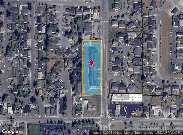
1011 S Laventure Rd, Mount Vernon, WA 98274
NEARBY LISTINGS FOR SALE OR LEASE
-
-
-
-
-
-
No Photo
-
-
View all Mount Vernon listings for sale on LoopNet.com
Property Detail
1011 S Laventure Rd
Other Market Areas
City Of Mount Vernon
Mount Vernon-Anacortes, WA
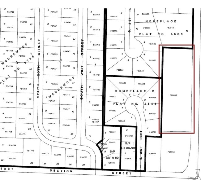
(1.7500 AC) THAT PORTION OF SOUTHEAST QUARTER OF THE SOUTHEAST QUARTER OF SECTION 20, TOWNSHIP 34, RANGE 4 EAST DESCRIBED AS FOLLOWS: BEGINNING AT A POINT ON THE NORTH LINE OF THE ROAD ALONG THE SOUTH LINE OF THE SAID SUBDIVISION, COMMONLY KNOWN AS S
P26686
Skagit
Multifamilydwelling
Washington
2025
87 SF
2025
Bellingham/Northwest
952405
DEMOGRAPHICS near 1011 S Laventure Rd
1 Mile
3 Mile
5 Mile
2024 Total Population
14,287
40,159
59,499
2029 Population
14,878
41,933
62,108
Pop Growth 2024-2029
+ 4.14%
+ 4.42%
+ 4.38%
Average Age
39
40
40
2024 Total Households
5,238
14,723
21,916
HH Growth 2024-2029
+ 4.28%
+ 4.52%
+ 4.51%
Median Household Inc
$64,258
$64,159
$65,310
Avg Household Size
2.60
2.60
2.60
2024 Avg HH Vehicles
2.00
2.00
2.00
Median Home Value
$413,026
$407,235
$427,293
Median Year Built
1979
1987
1986
Nearby Places
Map Layers
Map Styles
 Street
 Aerial
- Restaurants
- Banks
- Shops
- Fitness
- Groceries
PUBLIC TRANSPORTATION
COMMUTER RAIL
DRIVE
WALK
Distance
4 min
1.4 mi
AIRPORT
Bellingham International
DRIVE
WALK
Distance
Bellingham International
44 min
33.6 mi
Seattle Paine Field International
DRIVE
WALK
Distance
Seattle Paine Field International
54 min
42.0 mi
Freight Ports
DRIVE
WALK
Distance
31 min
18.4 mi
Nearby Properties
Address
Land Use
TOTAL SIZE
Lot Size
Zoning
Address
Land Use
TOTAL SIZE
Lot Size
Zoning
404,511 SF
9.01 AC
Address
Land Use
TOTAL SIZE
Lot Size
Zoning
16,345 SF
32.99 AC
Address
Land Use
TOTAL SIZE
Lot Size
Zoning
Address
Land Use
TOTAL SIZE
Lot Size
Zoning
Address
Land Use
TOTAL SIZE
Lot Size
Zoning
77,414 SF
15.20 AC
Address
Land Use
TOTAL SIZE
Lot Size
Zoning
212,480 SF
35.36 AC
Address
Land Use
TOTAL SIZE
Lot Size
Zoning
105,000 SF
1 AC
Address
Land Use
TOTAL SIZE
Lot Size
Zoning
200,145 SF
9.35 AC
Address
Land Use
TOTAL SIZE
Lot Size
Zoning
Address
Land Use
TOTAL SIZE
Lot Size
Zoning
138,226 SF
30.55 AC
Address
Land Use
TOTAL SIZE
Lot Size
Zoning
2,468 SF
0.68 AC
Address
Land Use
TOTAL SIZE
Lot Size
Zoning
64,668 SF
0.29 AC
Address
Land Use
TOTAL SIZE
Lot Size
Zoning
114,589 SF
10.63 AC
Address
Land Use
TOTAL SIZE
Lot Size
Zoning
52,239 SF
5.50 AC
Address
Land Use
TOTAL SIZE
Lot Size
Zoning
51,416 SF
Address
Land Use
TOTAL SIZE
Lot Size
Zoning
138,353 SF
10 AC
Address
Land Use
TOTAL SIZE
Lot Size
Zoning
68,326 SF
5.29 AC
Address
Land Use
TOTAL SIZE
Lot Size
Zoning
74,419 SF
2.16 AC
Address
Land Use
TOTAL SIZE
Lot Size
Zoning
44,812 SF
6 AC
Address
Land Use
TOTAL SIZE
Lot Size
Zoning
55,326 SF
9.12 AC
Address
Land Use
TOTAL SIZE
Lot Size
Zoning
143,806 SF
5.50 AC
Address
Land Use
TOTAL SIZE
Lot Size
Zoning
93,720 SF
4.82 AC
Address
Land Use
TOTAL SIZE
Lot Size
Zoning
2,195 SF
7.52 AC
Address
Land Use
TOTAL SIZE
Lot Size
Zoning
60,484 SF
4.78 AC
Address
Land Use
TOTAL SIZE
Lot Size
Zoning
40,166 SF
2.75 AC
Address
Land Use
TOTAL SIZE
Lot Size
Zoning
42,634 SF
15.86 AC
Address
Land Use
TOTAL SIZE
Lot Size
Zoning
53,510 SF
3.67 AC
Address
Land Use
TOTAL SIZE
Lot Size
Zoning
77,090 SF
12.60 AC
Address
Land Use
TOTAL SIZE
Lot Size
Zoning
The World's #1 Commercial Real Estate Marketplace
Connect with us
© 2026 CoStar Group
The information above has been obtained from sources believed reliable. While we do not doubt its accuracy we have not verified it and make no guarantee, warranty or representation about it. It is your responsibility to independently confirm its accuracy and completeness. Any projections, opinions, assumptions, or estimates used are for example only and do not represent the current or future performance of the property. The value of this transaction to you depends on tax and other factors which should be evaluated by your tax, financial, and legal advisors. You and your advisors should conduct a careful, independent investigation of the property to determine to your satisfaction the suitability of the property for your needs.