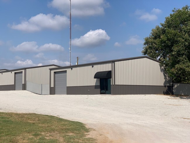
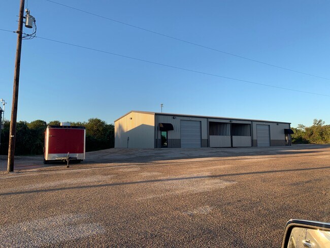
Property Record
1011 Upper Denton Rd, Weatherford, TX 76085


Current Lease Availabilities
Property Detail
1011 Upper Denton Rd
R000046495
ACRES: 9.650 ABST: 847, TOWN & COUNTRY PARK
Commercialnec
Parker
B and X Area of moderate flood hazard, usually the area between the limits of the 100-year and 500-year floods.
Texas
2024
9.65 AC
2025
Parker County
140102
Dallas/Ft Worth
51,200 SF
Dallas-Fort Worth-Arlington, TX
NEARBY LISTINGS FOR SALE OR LEASE
DEMOGRAPHICS near 1011 Upper Denton Rd
1 mile
3 mile
5 mile
2025 Total Population
3,427
31,804
51,669
2030 Population
3,985
37,039
60,215
Pop Growth 2025-2030
+ 16.28%
+ 16.46%
+ 16.54%
Average Age
40
39
40
2025 Total Households
1,309
12,361
19,681
HH Growth 2025-2030
+ 15.74%
+ 15.82%
+ 15.84%
Median Household Inc
$52,500
$65,723
$76,780
Avg Household Size
2.40
2.40
2.50
2025 Avg HH Vehicles
2.00
2.00
2.00
Median Home Value
$270,300
$298,344
$338,005
Median Year Built
1984
1994
1999
Nearby Places
Map Layers
Map Styles
 Street
 Aerial
Layers
 Traffic
 Biking
Places
Listings with unknown addresses are not visible on the map
- Restaurants
- Banks
- Shops
- Fitness
- Groceries
Nearby Properties
Address
Land Use
TOTAL SIZE
Lot Size
Zoning
Address
Land Use
TOTAL SIZE
Lot Size
Zoning
341,996 SF
16.60 AC
Address
Land Use
TOTAL SIZE
Lot Size
Zoning
399,466 SF
11.50 AC
Address
Land Use
TOTAL SIZE
Lot Size
Zoning
279,600 SF
14.43 AC
Address
Land Use
TOTAL SIZE
Lot Size
Zoning
141,292 SF
13.88 AC
Address
Land Use
TOTAL SIZE
Lot Size
Zoning
167,850 SF
13.50 AC
Address
Land Use
TOTAL SIZE
Lot Size
Zoning
171,147 SF
8.77 AC
Address
Land Use
TOTAL SIZE
Lot Size
Zoning
Address
Land Use
TOTAL SIZE
Lot Size
Zoning
103,600 SF
6 AC
Address
Land Use
TOTAL SIZE
Lot Size
Zoning
75,854 SF
8.84 AC
Address
Land Use
TOTAL SIZE
Lot Size
Zoning
255,314 SF
14.27 AC
Address
Land Use
TOTAL SIZE
Lot Size
Zoning
16,624 SF
9.53 AC
Address
Land Use
TOTAL SIZE
Lot Size
Zoning
31.61 AC
Address
Land Use
TOTAL SIZE
Lot Size
Zoning
6.95 AC
Address
Land Use
TOTAL SIZE
Lot Size
Zoning
75,968 SF
6.82 AC
Address
Land Use
TOTAL SIZE
Lot Size
Zoning
55,112 SF
4.68 AC
Address
Land Use
TOTAL SIZE
Lot Size
Zoning
104,188 SF
12.73 AC
Address
Land Use
TOTAL SIZE
Lot Size
Zoning
81,112 SF
7.34 AC
Address
Land Use
TOTAL SIZE
Lot Size
Zoning
23,886 SF
23.19 AC
Address
Land Use
TOTAL SIZE
Lot Size
Zoning
27,669 SF
3.58 AC
Address
Land Use
TOTAL SIZE
Lot Size
Zoning
50,112 SF
2.97 AC
Address
Land Use
TOTAL SIZE
Lot Size
Zoning
49,054 SF
2.76 AC
Address
Land Use
TOTAL SIZE
Lot Size
Zoning
26,050 SF
5.44 AC
Address
Land Use
TOTAL SIZE
Lot Size
Zoning
103,125 SF
18.25 AC
Address
Land Use
TOTAL SIZE
Lot Size
Zoning
50,446 SF
2.05 AC
Address
Land Use
TOTAL SIZE
Lot Size
Zoning
155,253 SF
9.31 AC
Address
Land Use
TOTAL SIZE
Lot Size
Zoning
103,631 SF
7.78 AC
Address
Land Use
TOTAL SIZE
Lot Size
Zoning
146,651 SF
7.73 AC
Address
Land Use
TOTAL SIZE
Lot Size
Zoning
22,356 SF
0.17 AC
Address
Land Use
TOTAL SIZE
Lot Size
Zoning
210,342 SF
5 AC
The World's #1 Commercial Real Estate Marketplace
Connect with us
© 2026 CoStar Group
The information above has been obtained from sources believed reliable. While we do not doubt its accuracy we have not verified it and make no guarantee, warranty or representation about it. It is your responsibility to independently confirm its accuracy and completeness. Any projections, opinions, assumptions, or estimates used are for example only and do not represent the current or future performance of the property. The value of this transaction to you depends on tax and other factors which should be evaluated by your tax, financial, and legal advisors. You and your advisors should conduct a careful, independent investigation of the property to determine to your satisfaction the suitability of the property for your needs.