Property Record
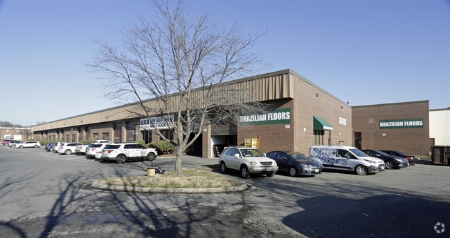
10111 Bacon Dr, Beltsville, MD 20705


Current Lease Availabilities
NEARBY LISTINGS FOR SALE OR LEASE
Property Detail
10111 Bacon Dr
Washington-Arlington-Alexandria, DC-VA-MD-WV
Beltsville Indust Center
01-0021550
BELTSVILLE
Warehouse
Prince George's
X
Maryland
24033C0043E
2
2024
1.68 AC
2025
Beltsville
807404
Washington, DC
31,229 SF
DEMOGRAPHICS near 10111 Bacon Dr
1 Mile
3 Mile
5 Mile
2024 Total Population
6,800
84,573
315,371
2029 Population
6,608
82,696
309,064
Pop Growth 2024-2029
(2.82%)
(2.22%)
(2.00%)
Average Age
38
38
37
2024 Total Households
2,475
29,787
103,842
HH Growth 2024-2029
(2.87%)
(2.27%)
(2.09%)
Median Household Inc
$103,125
$83,381
$82,977
Avg Household Size
2.70
2.60
2.80
2024 Avg HH Vehicles
2.00
2.00
2.00
Median Home Value
$383,751
$393,135
$395,120
Median Year Built
1979
1975
1975
Nearby Places
Map Layers
Map Styles
 Street
 Aerial
- Restaurants
- Banks
- Shops
- Fitness
- Groceries
PUBLIC TRANSPORTATION
COMMUTER RAIL
Greenbelt (Green Line - Washington Metropolitan Area Transit Authority Metrorail (Metrorail))
DRIVE
WALK
Distance
Greenbelt (Green Line - Washington Metropolitan Area Transit Authority Metrorail (Metrorail))
6 min
2.8 mi
Greenbelt (CAMDEN - WASHINGTON - Maryland Area Regional Commuter Trains (The MARC), Camden Line - Maryland Area Regional Commuter Trains (The MARC))
DRIVE
WALK
Distance
Greenbelt (CAMDEN - WASHINGTON - Maryland Area Regional Commuter Trains (The MARC), Camden Line - Maryland Area Regional Commuter Trains (The MARC))
6 min
2.9 mi
AIRPORT
Baltimore/Washington International Thurgood Marshall
DRIVE
WALK
Distance
Baltimore/Washington International Thurgood Marshall
32 min
20.3 mi
Ronald Reagan Washington Ntl
DRIVE
WALK
Distance
Ronald Reagan Washington Ntl
34 min
20.6 mi
Washington Dulles International
DRIVE
WALK
Distance
Washington Dulles International
55 min
35.8 mi
Freight Ports
Port of Baltimore
DRIVE
WALK
Distance
Port of Baltimore
38 min
27.6 mi
Nearby Properties
Address
Land Use
TOTAL SIZE
Lot Size
Zoning
Address
Land Use
TOTAL SIZE
Lot Size
Zoning
456,429 SF
35.07 AC
I3
Address
Land Use
TOTAL SIZE
Lot Size
Zoning
1,244,733 SF
38.03 AC
RE2
Address
Land Use
TOTAL SIZE
Lot Size
Zoning
639,347 SF
2.28 AC
RTOLE
Address
Land Use
TOTAL SIZE
Lot Size
Zoning
3.53 AC
RTOLE
Address
Land Use
TOTAL SIZE
Lot Size
Zoning
1,146,407 SF
60.25 AC
AG
Address
Land Use
TOTAL SIZE
Lot Size
Zoning
2.05 AC
RTOLE
Address
Land Use
TOTAL SIZE
Lot Size
Zoning
508 SF
7.27 AC
LTOE
Address
Land Use
TOTAL SIZE
Lot Size
Zoning
514,064 SF
7.37 AC
NAC
Address
Land Use
TOTAL SIZE
Lot Size
Zoning
0.79 AC
RTOLE
Address
Land Use
TOTAL SIZE
Lot Size
Zoning
330,555 SF
2.12 AC
NAC
Address
Land Use
TOTAL SIZE
Lot Size
Zoning
15.90 AC
RTOLE
Address
Land Use
TOTAL SIZE
Lot Size
Zoning
2,240.90 AC
ROS
Address
Land Use
TOTAL SIZE
Lot Size
Zoning
6.39 AC
RMF48
Address
Land Use
TOTAL SIZE
Lot Size
Zoning
569,794 SF
5.70 AC
RMF48
Address
Land Use
TOTAL SIZE
Lot Size
Zoning
43,382 SF
2.18 AC
Address
Land Use
TOTAL SIZE
Lot Size
Zoning
17.48 AC
RMF20
Address
Land Use
TOTAL SIZE
Lot Size
Zoning
20.79 AC
RTOLE
Address
Land Use
TOTAL SIZE
Lot Size
Zoning
256,662 SF
3.69 AC
LTOE
Address
Land Use
TOTAL SIZE
Lot Size
Zoning
22.87 AC
RTOLE
Address
Land Use
TOTAL SIZE
Lot Size
Zoning
285,116 SF
14.62 AC
AG
Address
Land Use
TOTAL SIZE
Lot Size
Zoning
769.33 AC
ROS
Address
Land Use
TOTAL SIZE
Lot Size
Zoning
18.58 AC
RTOLE
Address
Land Use
TOTAL SIZE
Lot Size
Zoning
39.59 AC
ROS
Address
Land Use
TOTAL SIZE
Lot Size
Zoning
30,426 SF
12.96 AC
NAC
Address
Land Use
TOTAL SIZE
Lot Size
Zoning
598,096 SF
24.36 AC
NAC
Address
Land Use
TOTAL SIZE
Lot Size
Zoning
142,530 SF
12.77 AC
CGO
Address
Land Use
TOTAL SIZE
Lot Size
Zoning
16.09 AC
RMF20
Address
Land Use
TOTAL SIZE
Lot Size
Zoning
394,180 SF
9.62 AC
LTOE
Address
Land Use
TOTAL SIZE
Lot Size
Zoning
15.09 AC
RTOLE
Address
Land Use
TOTAL SIZE
Lot Size
Zoning
169,000 SF
0.65 AC
I3
The World's #1 Commercial Real Estate Marketplace
Connect with us
© 2025 CoStar Group
The information above has been obtained from sources believed reliable. While we do not doubt its accuracy we have not verified it and make no guarantee, warranty or representation about it. It is your responsibility to independently confirm its accuracy and completeness. Any projections, opinions, assumptions, or estimates used are for example only and do not represent the current or future performance of the property. The value of this transaction to you depends on tax and other factors which should be evaluated by your tax, financial, and legal advisors. You and your advisors should conduct a careful, independent investigation of the property to determine to your satisfaction the suitability of the property for your needs.