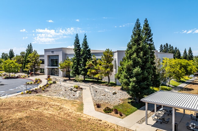
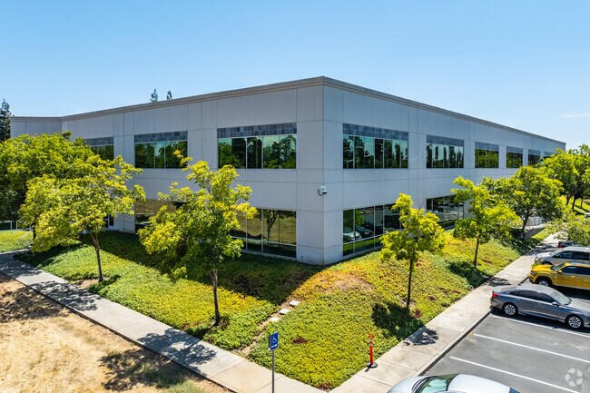
Property Record
10111 Old Placerville Rd, Sacramento, CA 95827

NEARBY LISTINGS FOR SALE OR LEASE
Property Detail
10111 Old Placerville Rd
077-0360-034
Mather Business Park
Officebuilding
PCLS 2 & 3 MATHER BUSINESS PARK PM BK 70 PG 28, LYING ELY &SLY OF LN DES AS BEG AT SE COR PCL 1 OF SD SUB PT LOC ON THENLY
AE
Sacramento
06067C0205H
California
2024
5.43 AC
2025
Highway 50 Corridor
009006
Sacramento
70,272 SF
Sacramento--Roseville--Arden-Arcade, CA
DEMOGRAPHICS near 10111 Old Placerville Rd
1 Mile
3 Mile
5 Mile
2024 Total Population
10,940
88,954
201,765
2029 Population
10,946
89,525
203,213
Pop Growth 2024-2029
+ 0.05%
+ 0.64%
+ 0.72%
Average Age
37
39
40
2024 Total Households
3,658
32,613
77,729
HH Growth 2024-2029
+ 0.03%
+ 0.64%
+ 0.72%
Median Household Inc
$67,642
$83,834
$81,613
Avg Household Size
2.90
2.70
2.50
2024 Avg HH Vehicles
2.00
2.00
2.00
Median Home Value
$345,017
$427,057
$459,511
Median Year Built
1975
1975
1973
Nearby Places
Map Layers
Map Styles
 Street
 Aerial
- Restaurants
- Banks
- Shops
- Fitness
- Groceries
PUBLIC TRANSPORTATION
AIRPORT
Sacramento International
DRIVE
WALK
Distance
Sacramento International
28 min
23.9 mi
Nearby Properties
Address
Land Use
TOTAL SIZE
Lot Size
Zoning
Address
Land Use
TOTAL SIZE
Lot Size
Zoning
266,841 SF
47.29 AC
RD-5
Address
Land Use
TOTAL SIZE
Lot Size
Zoning
251,024 SF
5.19 AC
SPA (CVSPA
Address
Land Use
TOTAL SIZE
Lot Size
Zoning
223,046 SF
10.99 AC
RD 20
Address
Land Use
TOTAL SIZE
Lot Size
Zoning
109,805 SF
20.04 AC
OPMU
Address
Land Use
TOTAL SIZE
Lot Size
Zoning
181,573 SF
12.10 AC
SPA (MFSPA
Address
Land Use
TOTAL SIZE
Lot Size
Zoning
192,500 SF
11.78 AC
OPMU
Address
Land Use
TOTAL SIZE
Lot Size
Zoning
323,088 SF
19.69 AC
OPMU
Address
Land Use
TOTAL SIZE
Lot Size
Zoning
139,500 SF
5.21 AC
MP
Address
Land Use
TOTAL SIZE
Lot Size
Zoning
162,023 SF
8.96 AC
OIMU
Address
Land Use
TOTAL SIZE
Lot Size
Zoning
0.21 AC
RD-5
Address
Land Use
TOTAL SIZE
Lot Size
Zoning
6.31 AC
RC (ZSPA)
Address
Land Use
TOTAL SIZE
Lot Size
Zoning
135,375 SF
7.40 AC
RD-30
Address
Land Use
TOTAL SIZE
Lot Size
Zoning
221,337 SF
12.19 AC
RD 25
Address
Land Use
TOTAL SIZE
Lot Size
Zoning
132,149 SF
8.29 AC
OPMU
Address
Land Use
TOTAL SIZE
Lot Size
Zoning
95,174 SF
5.29 AC
SPA (MFSPA
Address
Land Use
TOTAL SIZE
Lot Size
Zoning
156,032 SF
9.31 AC
OPMU
Address
Land Use
TOTAL SIZE
Lot Size
Zoning
218,216 SF
14.22 AC
OPMU
Address
Land Use
TOTAL SIZE
Lot Size
Zoning
169,618 SF
10.44 AC
RD-4
Address
Land Use
TOTAL SIZE
Lot Size
Zoning
198,413 SF
9.24 AC
RD 30
Address
Land Use
TOTAL SIZE
Lot Size
Zoning
135,197 SF
11.38 AC
SPA (CVSPA
Address
Land Use
TOTAL SIZE
Lot Size
Zoning
12.47 AC
RD 30
Address
Land Use
TOTAL SIZE
Lot Size
Zoning
457,088 SF
12.50 AC
RD 30
Address
Land Use
TOTAL SIZE
Lot Size
Zoning
98,767 SF
6.43 AC
BP (ZSPA)
Address
Land Use
TOTAL SIZE
Lot Size
Zoning
302,966 SF
15.94 AC
RD 30
Address
Land Use
TOTAL SIZE
Lot Size
Zoning
258,819 SF
13.47 AC
RD 30
Address
Land Use
TOTAL SIZE
Lot Size
Zoning
8,724 SF
101.84 AC
M-2 (SM)
Address
Land Use
TOTAL SIZE
Lot Size
Zoning
164,149 SF
9.31 AC
LI (ZSPA)
Address
Land Use
TOTAL SIZE
Lot Size
Zoning
110,960 SF
6.62 AC
SPA (MFSPA
Address
Land Use
TOTAL SIZE
Lot Size
Zoning
115,593 SF
6.31 AC
OPMU
Address
Land Use
TOTAL SIZE
Lot Size
Zoning
184,249 SF
10.72 AC
OIMU (FBSP
The World's #1 Commercial Real Estate Marketplace
Connect with us
© 2026 CoStar Group
The information above has been obtained from sources believed reliable. While we do not doubt its accuracy we have not verified it and make no guarantee, warranty or representation about it. It is your responsibility to independently confirm its accuracy and completeness. Any projections, opinions, assumptions, or estimates used are for example only and do not represent the current or future performance of the property. The value of this transaction to you depends on tax and other factors which should be evaluated by your tax, financial, and legal advisors. You and your advisors should conduct a careful, independent investigation of the property to determine to your satisfaction the suitability of the property for your needs.