Property Record
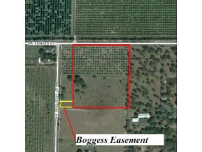
10112 Sw Boggess Ave, Arcadia, FL 34269

NEARBY LISTINGS FOR SALE OR LEASE
Property Detail
10112 Sw Boggess Ave
20-39-24-0000-0022-0000
NW1/4 OF NW1/4 OF NE1/4 LESS & EXCEPT THAT PART OF: BEG AT NE COR OF NE1/4 NW1/4 OF NE1/4 TH N 89D48M46S W ALG N LI SAID TRACT 403.23 FT TO POB TH CONT SAME LI 320.23 FT TH S 00D13M 39S W 994.95 FT TO POINT ON S LI OF N1/2 OF SW1/4 OF NW1/4 NE1/4 TH
Pasture
DeSoto
AE
Florida
12027C0283C
10.04 AC
2024
Florida Central South Area
2024
Other Market Areas
010406
Arcadia, FL
5,351 SF
DEMOGRAPHICS near 10112 Sw Boggess Ave
1 Mile
3 Mile
5 Mile
2024 Total Population
62
1,482
4,409
2029 Population
68
1,588
4,892
Pop Growth 2024-2029
+ 9.68%
+ 7.15%
+ 10.95%
Average Age
40
49
49
2024 Total Households
22
610
1,865
HH Growth 2024-2029
+ 13.64%
+ 7.70%
+ 11.69%
Median Household Inc
$56,249
$47,474
$47,605
Avg Household Size
2.90
2.20
2.20
2024 Avg HH Vehicles
2.00
2.00
2.00
Median Home Value
$262,499
$130,451
$177,033
Median Year Built
1994
1990
1989
Nearby Places
Map Layers
Map Styles
 Street
 Aerial
- Restaurants
- Banks
- Shops
- Fitness
- Groceries
PUBLIC TRANSPORTATION
AIRPORT
Punta Gorda
DRIVE
WALK
Distance
Punta Gorda
26 min
15.3 mi
Freight Ports
Port Manatee
DRIVE
WALK
Distance
Port Manatee
100 min
75.7 mi
Nearby Properties
Address
Land Use
TOTAL SIZE
Lot Size
Zoning
Address
Land Use
TOTAL SIZE
Lot Size
Zoning
1,225,024 SF
170.84 AC
IL
Address
Land Use
TOTAL SIZE
Lot Size
Zoning
2,025 SF
28.05 AC
RVC
Address
Land Use
TOTAL SIZE
Lot Size
Zoning
27,214 SF
7.92 AC
A-5
Address
Land Use
TOTAL SIZE
Lot Size
Zoning
4,800 SF
40.53 AC
PUD
Address
Land Use
TOTAL SIZE
Lot Size
Zoning
8,838 SF
2.43 AC
RMF-6
Address
Land Use
TOTAL SIZE
Lot Size
Zoning
7,050 SF
4.49 AC
RSF-3
Address
Land Use
TOTAL SIZE
Lot Size
Zoning
10,151 SF
3.33 AC
A-5
Address
Land Use
TOTAL SIZE
Lot Size
Zoning
5,119 SF
20.72 AC
A-10
Address
Land Use
TOTAL SIZE
Lot Size
Zoning
11,218 SF
58.49 AC
A-10
Address
Land Use
TOTAL SIZE
Lot Size
Zoning
160 AC
A-10
Address
Land Use
TOTAL SIZE
Lot Size
Zoning
3,462 SF
1.83 AC
IL
Address
Land Use
TOTAL SIZE
Lot Size
Zoning
5,274 SF
5 AC
RMF-M
Address
Land Use
TOTAL SIZE
Lot Size
Zoning
44.06 AC
RMF-6
Address
Land Use
TOTAL SIZE
Lot Size
Zoning
51 AC
RMF-6
Address
Land Use
TOTAL SIZE
Lot Size
Zoning
1,430 SF
186.36 AC
A-10
Address
Land Use
TOTAL SIZE
Lot Size
Zoning
323.91 AC
A-10
Address
Land Use
TOTAL SIZE
Lot Size
Zoning
7,915 SF
40.26 AC
A-5
Address
Land Use
TOTAL SIZE
Lot Size
Zoning
7,202 SF
1.12 AC
ROI
Address
Land Use
TOTAL SIZE
Lot Size
Zoning
3,526 SF
1.13 AC
RSF-3
Address
Land Use
TOTAL SIZE
Lot Size
Zoning
3,040 SF
10.05 AC
A-10
Address
Land Use
TOTAL SIZE
Lot Size
Zoning
292 AC
A-10
Address
Land Use
TOTAL SIZE
Lot Size
Zoning
5,485 SF
10 AC
A-5
Address
Land Use
TOTAL SIZE
Lot Size
Zoning
3,558 SF
10.39 AC
A-10
Address
Land Use
TOTAL SIZE
Lot Size
Zoning
2,006 SF
10.01 AC
A-10
Address
Land Use
TOTAL SIZE
Lot Size
Zoning
3,060 SF
10 AC
A-5
Address
Land Use
TOTAL SIZE
Lot Size
Zoning
7,489 SF
5.79 AC
RMF-M
Address
Land Use
TOTAL SIZE
Lot Size
Zoning
4,118 SF
30.59 AC
A-10
Address
Land Use
TOTAL SIZE
Lot Size
Zoning
9,100 SF
1.87 AC
RMF-M
Address
Land Use
TOTAL SIZE
Lot Size
Zoning
2,001 SF
31.95 AC
A-5
Address
Land Use
TOTAL SIZE
Lot Size
Zoning
6,903 SF
1 AC
A-5
The World's #1 Commercial Real Estate Marketplace
Connect with us
© 2025 CoStar Group
The information above has been obtained from sources believed reliable. While we do not doubt its accuracy we have not verified it and make no guarantee, warranty or representation about it. It is your responsibility to independently confirm its accuracy and completeness. Any projections, opinions, assumptions, or estimates used are for example only and do not represent the current or future performance of the property. The value of this transaction to you depends on tax and other factors which should be evaluated by your tax, financial, and legal advisors. You and your advisors should conduct a careful, independent investigation of the property to determine to your satisfaction the suitability of the property for your needs.