Property Record
10113 E 191St St, Noblesville, IN 46060


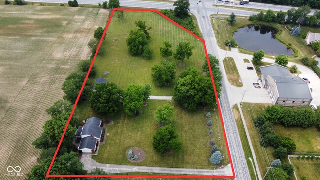
This Property Is For Sale
NEARBY LISTINGS FOR SALE OR LEASE
Property Detail
10113 E 191St St
Indianapolis-Carmel-Greenwood, IN
Noblesville Twp
29-07-29-000-018.000-012
Hamilton
Sfr
Indiana
X
4.04 AC
18057C0153G
Far North Hamilton Cnty
2,084 SF
Indianapolis
DEMOGRAPHICS near 10113 E 191St St
1 Mile
3 Mile
5 Mile
2024 Total Population
5,932
28,422
80,078
2029 Population
6,588
31,989
90,101
Pop Growth 2024-2029
+ 11.06%
+ 12.55%
+ 12.52%
Average Age
37
39
39
2024 Total Households
2,037
10,701
29,953
HH Growth 2024-2029
+ 11.05%
+ 12.55%
+ 12.50%
Median Household Inc
$99,713
$81,905
$86,795
Avg Household Size
2.80
2.60
2.60
2024 Avg HH Vehicles
2.00
2.00
2.00
Median Home Value
$255,237
$256,419
$273,855
Median Year Built
1996
1992
2000
Nearby Places
Map Layers
Map Styles
 Street
 Aerial
- Restaurants
- Banks
- Shops
- Fitness
- Groceries
PUBLIC TRANSPORTATION
AIRPORT
Indianapolis International
DRIVE
WALK
Distance
Indianapolis International
60 min
38.1 mi
Freight Ports
Port of Toledo
DRIVE
WALK
Distance
Port of Toledo
251 min
201.8 mi
Nearby Properties
Address
Land Use
TOTAL SIZE
Lot Size
Zoning
Address
Land Use
TOTAL SIZE
Lot Size
Zoning
517,873 SF
15.83 AC
Address
Land Use
TOTAL SIZE
Lot Size
Zoning
317,049 SF
38.45 AC
Address
Land Use
TOTAL SIZE
Lot Size
Zoning
212,035 SF
4.42 AC
Address
Land Use
TOTAL SIZE
Lot Size
Zoning
346,059 SF
7.88 AC
Address
Land Use
TOTAL SIZE
Lot Size
Zoning
271,049 SF
15.44 AC
Address
Land Use
TOTAL SIZE
Lot Size
Zoning
279,101 SF
14.95 AC
Address
Land Use
TOTAL SIZE
Lot Size
Zoning
275,764 SF
14.88 AC
Address
Land Use
TOTAL SIZE
Lot Size
Zoning
214,828 SF
21.10 AC
Address
Land Use
TOTAL SIZE
Lot Size
Zoning
229,136 SF
30.77 AC
Address
Land Use
TOTAL SIZE
Lot Size
Zoning
204,167 SF
14 AC
Address
Land Use
TOTAL SIZE
Lot Size
Zoning
108,805 SF
7 AC
Address
Land Use
TOTAL SIZE
Lot Size
Zoning
154,430 SF
12.28 AC
Address
Land Use
TOTAL SIZE
Lot Size
Zoning
110,986 SF
12.28 AC
Address
Land Use
TOTAL SIZE
Lot Size
Zoning
216,122 SF
17.70 AC
Address
Land Use
TOTAL SIZE
Lot Size
Zoning
125,261 SF
0.94 AC
Address
Land Use
TOTAL SIZE
Lot Size
Zoning
209,236 SF
17.88 AC
Address
Land Use
TOTAL SIZE
Lot Size
Zoning
200,607 SF
18.78 AC
Address
Land Use
TOTAL SIZE
Lot Size
Zoning
133,924 SF
0.67 AC
Address
Land Use
TOTAL SIZE
Lot Size
Zoning
103,910 SF
0.43 AC
Address
Land Use
TOTAL SIZE
Lot Size
Zoning
102,021 SF
28.66 AC
Address
Land Use
TOTAL SIZE
Lot Size
Zoning
90,425 SF
6.67 AC
Address
Land Use
TOTAL SIZE
Lot Size
Zoning
86,933 SF
5 AC
Address
Land Use
TOTAL SIZE
Lot Size
Zoning
75,836 SF
0.35 AC
Address
Land Use
TOTAL SIZE
Lot Size
Zoning
121,077 SF
9.32 AC
Address
Land Use
TOTAL SIZE
Lot Size
Zoning
100,404 SF
8.85 AC
Address
Land Use
TOTAL SIZE
Lot Size
Zoning
137,409 SF
13.43 AC
Address
Land Use
TOTAL SIZE
Lot Size
Zoning
55,264 SF
14.29 AC
Address
Land Use
TOTAL SIZE
Lot Size
Zoning
111,220 SF
0.85 AC
Address
Land Use
TOTAL SIZE
Lot Size
Zoning
151,077 SF
13.35 AC
Address
Land Use
TOTAL SIZE
Lot Size
Zoning
87,916 SF
12.56 AC
The World's #1 Commercial Real Estate Marketplace
Connect with us
© 2026 CoStar Group
The information above has been obtained from sources believed reliable. While we do not doubt its accuracy we have not verified it and make no guarantee, warranty or representation about it. It is your responsibility to independently confirm its accuracy and completeness. Any projections, opinions, assumptions, or estimates used are for example only and do not represent the current or future performance of the property. The value of this transaction to you depends on tax and other factors which should be evaluated by your tax, financial, and legal advisors. You and your advisors should conduct a careful, independent investigation of the property to determine to your satisfaction the suitability of the property for your needs.