Property Record
10119 E Truman Rd, Independence, MO 64052
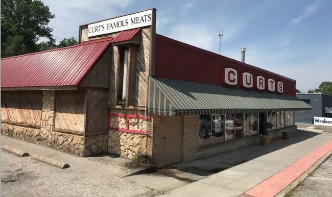

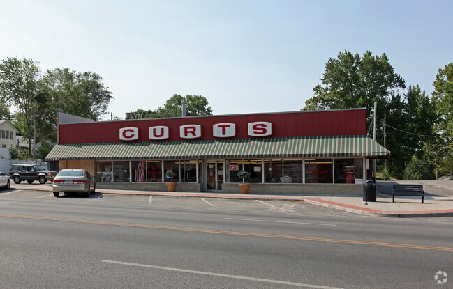
Property Detail
10119 E Truman Rd
Kansas City, MO-KS
MAYWOOD PARK N 82 OF E 4 LOT 18 & N 82 OF LOT 19
27-130-07-02-01-0-00-000
Jackson
Storebuilding
Missouri
B and X Area of moderate flood hazard, usually the area between the limits of the 100-year and 500-year floods.
18,19
2024
0.08 AC
2025
East Jackson County
011800
Kansas City
3,075 SF
NEARBY LISTINGS FOR SALE OR LEASE
DEMOGRAPHICS near 10119 E Truman Rd
1 mile
3 mile
5 mile
2025 Total Population
10,633
59,901
160,550
2030 Population
10,810
60,991
163,366
Pop Growth 2025-2030
+ 1.66%
+ 1.82%
+ 1.75%
Average Age
39
39
39
2025 Total Households
4,394
24,173
63,172
HH Growth 2025-2030
+ 1.66%
+ 1.77%
+ 1.59%
Median Household Inc
$49,925
$51,911
$51,677
Avg Household Size
2.30
2.40
2.40
2025 Avg HH Vehicles
2.00
2.00
2.00
Median Home Value
$97,353
$130,807
$140,562
Median Year Built
1947
1953
1958
Nearby Places
Map Layers
Map Styles
 Street
 Aerial
Transit
 Traffic
 Biking
Places
Listings with unknown addresses are not visible on the map
- Restaurants
- Banks
- Shops
- Fitness
- Groceries
PUBLIC TRANSPORTATION
AIRPORT
Kansas City International
Drive
Walk
Distance
Kansas City International
29 min
28.3 mi
Freight Ports
Port of Shreveport
Drive
Walk
Distance
Port of Shreveport
1 min
467.9 mi
SALE & LEASE HISTORY
LISTING DATE
SALE/LEASE

Jun 19, 2020
For Sale
Jul 20, 2018
For Sale
Apr 12, 2019
For Sale
Apr 05, 2021
For Lease
Nearby Properties
Address
Land Use
TOTAL SIZE
Lot Size
Zoning
Address
Land Use
TOTAL SIZE
Lot Size
Zoning
7,962 SF
7.80 AC
Address
Land Use
TOTAL SIZE
Lot Size
Zoning
253,472 SF
396.83 AC
Address
Land Use
TOTAL SIZE
Lot Size
Zoning
44,274 SF
9.40 AC
Address
Land Use
TOTAL SIZE
Lot Size
Zoning
32,777 SF
21.40 AC
Address
Land Use
TOTAL SIZE
Lot Size
Zoning
123,305 SF
15.51 AC
Address
Land Use
TOTAL SIZE
Lot Size
Zoning
213,615 SF
15.50 AC
Address
Land Use
TOTAL SIZE
Lot Size
Zoning
74,801 SF
8.93 AC
Address
Land Use
TOTAL SIZE
Lot Size
Zoning
138,353 SF
23.03 AC
Address
Land Use
TOTAL SIZE
Lot Size
Zoning
157,666 SF
18.54 AC
Address
Land Use
TOTAL SIZE
Lot Size
Zoning
139,713 SF
15.70 AC
Address
Land Use
TOTAL SIZE
Lot Size
Zoning
13,227 SF
287 AC
Address
Land Use
TOTAL SIZE
Lot Size
Zoning
76,410 SF
49.60 AC
Address
Land Use
TOTAL SIZE
Lot Size
Zoning
71,339 SF
0.68 AC
Address
Land Use
TOTAL SIZE
Lot Size
Zoning
113,667 SF
6.31 AC
Address
Land Use
TOTAL SIZE
Lot Size
Zoning
55,985 SF
20.93 AC
Address
Land Use
TOTAL SIZE
Lot Size
Zoning
70,555 SF
32.97 AC
Address
Land Use
TOTAL SIZE
Lot Size
Zoning
36,883 SF
14.60 AC
Address
Land Use
TOTAL SIZE
Lot Size
Zoning
229,425 SF
15.68 AC
Address
Land Use
TOTAL SIZE
Lot Size
Zoning
286,490 SF
37.30 AC
Address
Land Use
TOTAL SIZE
Lot Size
Zoning
9,768 SF
0.87 AC
Address
Land Use
TOTAL SIZE
Lot Size
Zoning
43,504 SF
Address
Land Use
TOTAL SIZE
Lot Size
Zoning
129,315 SF
15.90 AC
Address
Land Use
TOTAL SIZE
Lot Size
Zoning
79,609 SF
2.91 AC
Address
Land Use
TOTAL SIZE
Lot Size
Zoning
39,120 SF
1.87 AC
Address
Land Use
TOTAL SIZE
Lot Size
Zoning
57,732 SF
22.42 AC
Address
Land Use
TOTAL SIZE
Lot Size
Zoning
50,900 SF
13.80 AC
Address
Land Use
TOTAL SIZE
Lot Size
Zoning
58,946 SF
0.98 AC
Address
Land Use
TOTAL SIZE
Lot Size
Zoning
621,400 SF
Address
Land Use
TOTAL SIZE
Lot Size
Zoning
67,282 SF
4 AC
Address
Land Use
TOTAL SIZE
Lot Size
Zoning
552,135 SF
39.60 AC
The World's #1 Commercial Real Estate Marketplace
Connect with us
© 2026 CoStar Group
The information above has been obtained from sources believed reliable. While we do not doubt its accuracy we have not verified it and make no guarantee, warranty or representation about it. It is your responsibility to independently confirm its accuracy and completeness. Any projections, opinions, assumptions, or estimates used are for example only and do not represent the current or future performance of the property. The value of this transaction to you depends on tax and other factors which should be evaluated by your tax, financial, and legal advisors. You and your advisors should conduct a careful, independent investigation of the property to determine to your satisfaction the suitability of the property for your needs.