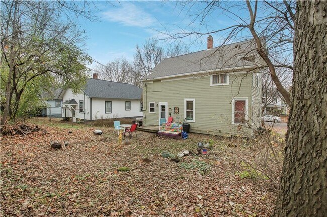
Property Record
1012 2Nd Ave, Eau Claire, WI 54703


NEARBY LISTINGS FOR SALE OR LEASE
-
-
View all Eau Claire listings for sale on LoopNet.com
Property Detail
1012 2Nd Ave
Eau Claire, WI
Thorps Corrected 2Nd Add
06-0399
THE N 45 FT OF LOT 3 BLK A & THE E 6.5 FT ADJ EXC THE W 110 FT CHAPMAN & THORPS CORRECTED 2ND ADD
Duplex
Eau Claire
AE
Wisconsin
55017C0725E
3
2024
0.10 AC
2024
Downtown Eau Claire
001200
Other Market Areas
1,536 SF
DEMOGRAPHICS near 1012 2Nd Ave
1 mile
3 mile
5 mile
2024 Total Population
13,882
61,436
92,077
2029 Population
14,425
63,776
95,833
Pop Growth 2024-2029
+ 3.91%
+ 3.81%
+ 4.08%
Average Age
32
37
39
2024 Total Households
5,847
25,221
38,070
HH Growth 2024-2029
+ 4.16%
+ 3.91%
+ 4.17%
Median Household Inc
$42,776
$58,119
$62,840
Avg Household Size
2.00
2.20
2.30
2024 Avg HH Vehicles
2.00
2.00
2.00
Median Home Value
$156,889
$217,846
$229,464
Median Year Built
1949
1971
1977
Nearby Places
Map Layers
Map Styles
 Street
 Aerial
Transit
 Traffic
 Biking
Places
Listings with unknown addresses are not visible on the map
- Restaurants
- Banks
- Shops
- Fitness
- Groceries
SALE & LEASE HISTORY
LISTING DATE
SALE/LEASE

Nov 16, 2022
For Sale
Nearby Properties
Address
Land Use
TOTAL SIZE
Lot Size
Zoning
Address
Land Use
TOTAL SIZE
Lot Size
Zoning
119.93 AC
Address
Land Use
TOTAL SIZE
Lot Size
Zoning
10.07 AC
FAIRFAX CO
Address
Land Use
TOTAL SIZE
Lot Size
Zoning
203,723 SF
Address
Land Use
TOTAL SIZE
Lot Size
Zoning
361,759 SF
8.46 AC
Address
Land Use
TOTAL SIZE
Lot Size
Zoning
206,042 SF
5.59 AC
Address
Land Use
TOTAL SIZE
Lot Size
Zoning
4.94 AC
Address
Land Use
TOTAL SIZE
Lot Size
Zoning
21.83 AC
I1
Address
Land Use
TOTAL SIZE
Lot Size
Zoning
21.41 AC
Address
Land Use
TOTAL SIZE
Lot Size
Zoning
2.70 AC
Address
Land Use
TOTAL SIZE
Lot Size
Zoning
1.36 AC
CBD
Address
Land Use
TOTAL SIZE
Lot Size
Zoning
114,683 SF
5.47 AC
C3H
Address
Land Use
TOTAL SIZE
Lot Size
Zoning
94,173 SF
9.36 AC
C3
Address
Land Use
TOTAL SIZE
Lot Size
Zoning
81,260 SF
2.32 AC
R4
Address
Land Use
TOTAL SIZE
Lot Size
Zoning
199,534 SF
7.23 AC
Address
Land Use
TOTAL SIZE
Lot Size
Zoning
1.05 AC
P
Address
Land Use
TOTAL SIZE
Lot Size
Zoning
105,434 SF
1.55 AC
CBD
Address
Land Use
TOTAL SIZE
Lot Size
Zoning
4.89 AC
FAIRFAX CO
Address
Land Use
TOTAL SIZE
Lot Size
Zoning
66,393 SF
12.95 AC
Address
Land Use
TOTAL SIZE
Lot Size
Zoning
65,378 SF
1.83 AC
Address
Land Use
TOTAL SIZE
Lot Size
Zoning
114,100 SF
2.64 AC
Address
Land Use
TOTAL SIZE
Lot Size
Zoning
68,024 SF
0.80 AC
CBD
Address
Land Use
TOTAL SIZE
Lot Size
Zoning
169,740 SF
19.59 AC
C3P
Address
Land Use
TOTAL SIZE
Lot Size
Zoning
163,428 SF
30.30 AC
I1P
Address
Land Use
TOTAL SIZE
Lot Size
Zoning
4.35 AC
Address
Land Use
TOTAL SIZE
Lot Size
Zoning
21,786 SF
4.14 AC
Address
Land Use
TOTAL SIZE
Lot Size
Zoning
88,350 SF
0.40 AC
Address
Land Use
TOTAL SIZE
Lot Size
Zoning
97,194 SF
7.39 AC
C3H
Address
Land Use
TOTAL SIZE
Lot Size
Zoning
85,790 SF
5.68 AC
C3
Address
Land Use
TOTAL SIZE
Lot Size
Zoning
0.71 AC
Address
Land Use
TOTAL SIZE
Lot Size
Zoning
66,497 SF
0.81 AC
CBDP
The World's #1 Commercial Real Estate Marketplace
Connect with us
© 2026 CoStar Group
The information above has been obtained from sources believed reliable. While we do not doubt its accuracy we have not verified it and make no guarantee, warranty or representation about it. It is your responsibility to independently confirm its accuracy and completeness. Any projections, opinions, assumptions, or estimates used are for example only and do not represent the current or future performance of the property. The value of this transaction to you depends on tax and other factors which should be evaluated by your tax, financial, and legal advisors. You and your advisors should conduct a careful, independent investigation of the property to determine to your satisfaction the suitability of the property for your needs.