Property Record
1012 Broad River Rd, Columbia, SC 29210


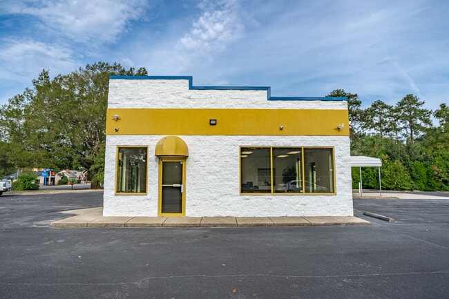
Property Detail
1012 Broad River Rd
07311-06-04
LOTS C & D 225X353.4X192X350.4 #SU HUFFMAN HGTS #PR RB2033-3964 K-90
Commercialnec
Richland
RAC
South Carolina
B and X Area of moderate flood hazard, usually the area between the limits of the 100-year and 500-year floods.
c
2025
1.69 AC
2024
St Andrews
010413
Columbia
1,922 SF
Columbia, SC
NEARBY LISTINGS FOR SALE OR LEASE
DEMOGRAPHICS near 1012 Broad River Rd
1 mile
3 mile
5 mile
2025 Total Population
6,310
63,428
160,600
2030 Population
6,532
66,014
167,326
Pop Growth 2025-2030
+ 3.52%
+ 4.08%
+ 4.19%
Average Age
35
38
37
2025 Total Households
3,405
29,715
68,984
HH Growth 2025-2030
+ 3.49%
+ 4.30%
+ 4.54%
Median Household Inc
$47,900
$50,428
$49,943
Avg Household Size
1.80
2.00
2.10
2025 Avg HH Vehicles
1.00
1.00
2.00
Median Home Value
$161,506
$201,580
$203,954
Median Year Built
1981
1976
1974
Nearby Places
Map Layers
Map Styles
 Street
 Aerial
Layers
 Traffic
 Biking
Places
Listings with unknown addresses are not visible on the map
- Restaurants
- Banks
- Shops
- Fitness
- Groceries
PUBLIC TRANSPORTATION
AIRPORT
Columbia Metro
Drive
Walk
Distance
Columbia Metro
24 min
11.5 mi
SALE & LEASE HISTORY
LISTING DATE
SALE/LEASE

Sep 24, 2016
For Sale
Oct 03, 2024
For Sale
Nearby Properties
Address
Land Use
TOTAL SIZE
Lot Size
Zoning
Address
Land Use
TOTAL SIZE
Lot Size
Zoning
160,510 SF
0.26 AC
DAC
Address
Land Use
TOTAL SIZE
Lot Size
Zoning
375,417 SF
3.92 AC
INS-GEN
Address
Land Use
TOTAL SIZE
Lot Size
Zoning
2.07 AC
DAC
Address
Land Use
TOTAL SIZE
Lot Size
Zoning
119,738 SF
10.30 AC
EC
Address
Land Use
TOTAL SIZE
Lot Size
Zoning
353,447 SF
0.53 AC
DAC
Address
Land Use
TOTAL SIZE
Lot Size
Zoning
128,160 SF
9.31 AC
RM-HD
Address
Land Use
TOTAL SIZE
Lot Size
Zoning
358,561 SF
42.10 AC
EC
Address
Land Use
TOTAL SIZE
Lot Size
Zoning
128,877 SF
24.71 AC
RM-HD
Address
Land Use
TOTAL SIZE
Lot Size
Zoning
163,868 SF
4.35 AC
CAC
Address
Land Use
TOTAL SIZE
Lot Size
Zoning
9,620 SF
18.91 AC
GC
Address
Land Use
TOTAL SIZE
Lot Size
Zoning
319,842 SF
0.78 AC
DAC
Address
Land Use
TOTAL SIZE
Lot Size
Zoning
183,392 SF
14.77 AC
RM-HD
Address
Land Use
TOTAL SIZE
Lot Size
Zoning
66,720 SF
19.20 AC
RM-2
Address
Land Use
TOTAL SIZE
Lot Size
Zoning
300,130 SF
7.56 AC
RAC
Address
Land Use
TOTAL SIZE
Lot Size
Zoning
290,324 SF
38.74 AC
RM-2
Address
Land Use
TOTAL SIZE
Lot Size
Zoning
278,912 SF
23.24 AC
RM-HD
Address
Land Use
TOTAL SIZE
Lot Size
Zoning
232,600 SF
17.65 AC
RM-2
Address
Land Use
TOTAL SIZE
Lot Size
Zoning
207,112 SF
16.86 AC
RM-HD
Address
Land Use
TOTAL SIZE
Lot Size
Zoning
221,614 SF
0.81 AC
DAC
Address
Land Use
TOTAL SIZE
Lot Size
Zoning
245,506 SF
14.13 AC
GC
Address
Land Use
TOTAL SIZE
Lot Size
Zoning
177,177 SF
9.50 AC
C-1
Address
Land Use
TOTAL SIZE
Lot Size
Zoning
220,568 SF
14.53 AC
RM-2
Address
Land Use
TOTAL SIZE
Lot Size
Zoning
231,468 SF
17.41 AC
RM-2
Address
Land Use
TOTAL SIZE
Lot Size
Zoning
237,885 SF
20.76 AC
RM-2
Address
Land Use
TOTAL SIZE
Lot Size
Zoning
161,636 SF
12.38 AC
RM-HD
Address
Land Use
TOTAL SIZE
Lot Size
Zoning
208,688 SF
13.02 AC
RM-HD
Address
Land Use
TOTAL SIZE
Lot Size
Zoning
247,360 SF
6.61 AC
EC
Address
Land Use
TOTAL SIZE
Lot Size
Zoning
86,493 SF
1.06 AC
RAC
Address
Land Use
TOTAL SIZE
Lot Size
Zoning
2,268 SF
27.70 AC
RM-1
Address
Land Use
TOTAL SIZE
Lot Size
Zoning
171,284 SF
10.50 AC
RG-2
The World's #1 Commercial Real Estate Marketplace
Connect with us
© 2026 CoStar Group
The information above has been obtained from sources believed reliable. While we do not doubt its accuracy we have not verified it and make no guarantee, warranty or representation about it. It is your responsibility to independently confirm its accuracy and completeness. Any projections, opinions, assumptions, or estimates used are for example only and do not represent the current or future performance of the property. The value of this transaction to you depends on tax and other factors which should be evaluated by your tax, financial, and legal advisors. You and your advisors should conduct a careful, independent investigation of the property to determine to your satisfaction the suitability of the property for your needs.