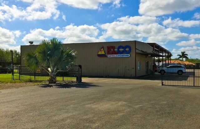
Property Record
1012 E Owassa Rd, Edinburg, TX 78542

Save to a Folder
{{folder.Name}}
{{folder.ListingIds.length}} Properties
{{folder.ListingIds.length}} Property
Create a New Folder
Property Detail
1012 E Owassa Rd
McAllen-Edinburg-Mission, TX
KELLY PHARR TRACT AN IRR TR-E150-W450-N754.65 LOT 80 2.40AC GR 2.33AC NET
K2400-00-000-0080-10
Hidalgo
Warehouse
Texas
2025
80
2025
2.33 AC
021706
Pharr
18,762 SF
McAllen/Edinburg/Pharr
NEARBY LISTINGS FOR SALE OR LEASE
DEMOGRAPHICS near 1012 E Owassa Rd
1 mile
3 mile
5 mile
2025 Total Population
9,232
83,569
249,070
2030 Population
9,603
87,326
261,048
Pop Growth 2025-2030
+ 4.02%
+ 4.50%
+ 4.81%
Average Age
32
34
35
2025 Total Households
2,662
25,574
80,491
HH Growth 2025-2030
+ 3.94%
+ 4.63%
+ 4.82%
Median Household Inc
$52,233
$59,351
$56,980
Avg Household Size
3.50
3.20
3.00
2025 Avg HH Vehicles
2.00
2.00
2.00
Median Home Value
$159,236
$167,912
$168,688
Median Year Built
2003
2003
1998
Nearby Places
Map Layers
Map Styles
 Street
 Aerial
Layers
 Traffic
 Biking
Places
Listings with unknown addresses are not visible on the map
- Restaurants
- Banks
- Shops
- Fitness
- Groceries
PUBLIC TRANSPORTATION
AIRPORT
McAllen International
Drive
Walk
Distance
McAllen International
16 min
12.2 mi
Freight Ports
Port of Brownsville
Drive
Walk
Distance
Port of Brownsville
71 min
63.4 mi
SALE & LEASE HISTORY
LISTING DATE
SALE/LEASE

Jan 30, 2017
For Sale
Dec 02, 2017
For Sale
Nearby Properties
Address
Land Use
TOTAL SIZE
Lot Size
Zoning
Address
Land Use
TOTAL SIZE
Lot Size
Zoning
414,619 SF
9.75 AC
Address
Land Use
TOTAL SIZE
Lot Size
Zoning
85,083 SF
12.84 AC
CO
Address
Land Use
TOTAL SIZE
Lot Size
Zoning
58,160 SF
36.96 AC
CO
Address
Land Use
TOTAL SIZE
Lot Size
Zoning
109,791 SF
8.82 AC
Address
Land Use
TOTAL SIZE
Lot Size
Zoning
184,900 SF
20.82 AC
Address
Land Use
TOTAL SIZE
Lot Size
Zoning
2 SF
32.26 AC
CO
Address
Land Use
TOTAL SIZE
Lot Size
Zoning
86,008 SF
10 AC
Address
Land Use
TOTAL SIZE
Lot Size
Zoning
5 SF
22.02 AC
Address
Land Use
TOTAL SIZE
Lot Size
Zoning
195,599 SF
21.46 AC
CO
Address
Land Use
TOTAL SIZE
Lot Size
Zoning
1 SF
17.61 AC
CO
Address
Land Use
TOTAL SIZE
Lot Size
Zoning
22,199 SF
1.96 AC
Address
Land Use
TOTAL SIZE
Lot Size
Zoning
122,692 SF
16.47 AC
Address
Land Use
TOTAL SIZE
Lot Size
Zoning
10,333 SF
36.75 AC
Address
Land Use
TOTAL SIZE
Lot Size
Zoning
73,272 SF
32.88 AC
Address
Land Use
TOTAL SIZE
Lot Size
Zoning
31.95 AC
Address
Land Use
TOTAL SIZE
Lot Size
Zoning
70,571 SF
14.31 AC
C
Address
Land Use
TOTAL SIZE
Lot Size
Zoning
1 SF
65.66 AC
Address
Land Use
TOTAL SIZE
Lot Size
Zoning
9 SF
36.37 AC
Address
Land Use
TOTAL SIZE
Lot Size
Zoning
76,685 SF
1.38 AC
Address
Land Use
TOTAL SIZE
Lot Size
Zoning
123,257 SF
5.70 AC
Address
Land Use
TOTAL SIZE
Lot Size
Zoning
252,640 SF
19.23 AC
Address
Land Use
TOTAL SIZE
Lot Size
Zoning
41,930 SF
3 AC
CO
Address
Land Use
TOTAL SIZE
Lot Size
Zoning
63,284 SF
15.29 AC
Address
Land Use
TOTAL SIZE
Lot Size
Zoning
198,456 SF
20.22 AC
RM
Address
Land Use
TOTAL SIZE
Lot Size
Zoning
3,890 SF
12.43 AC
Address
Land Use
TOTAL SIZE
Lot Size
Zoning
53,199 SF
5 AC
JAB
Address
Land Use
TOTAL SIZE
Lot Size
Zoning
2 SF
9.45 AC
Address
Land Use
TOTAL SIZE
Lot Size
Zoning
23,456 SF
9.67 AC
Address
Land Use
TOTAL SIZE
Lot Size
Zoning
33,829 SF
9.79 AC
C
Address
Land Use
TOTAL SIZE
Lot Size
Zoning
21.14 AC
The World's #1 Commercial Real Estate Marketplace
Connect with us
© 2026 CoStar Group
The information above has been obtained from sources believed reliable. While we do not doubt its accuracy we have not verified it and make no guarantee, warranty or representation about it. It is your responsibility to independently confirm its accuracy and completeness. Any projections, opinions, assumptions, or estimates used are for example only and do not represent the current or future performance of the property. The value of this transaction to you depends on tax and other factors which should be evaluated by your tax, financial, and legal advisors. You and your advisors should conduct a careful, independent investigation of the property to determine to your satisfaction the suitability of the property for your needs.