Property Record
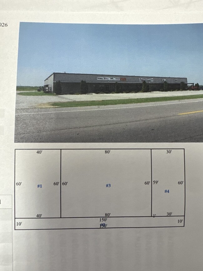
1012 E State Highway 84, Caruthersville, MO 63830

NEARBY LISTINGS FOR SALE OR LEASE
-
-
View all Caruthersville listings for sale on LoopNet.com
Property Detail
1012 E State Highway 84
Other Market Areas
LOT ADJ TO SW SIDE OF STATE HWY 84 IN NE1/4 SE1/4
16-32-07-00-000-00703
Pemiscot
Storesoffices
Missouri
2024
a
2025
1.10 AC
470300
Missouri South Area
4,800 SF
DEMOGRAPHICS near 1012 E State Highway 84
1 mile
3 mile
5 mile
2024 Total Population
24
4,884
7,981
2029 Population
22
4,608
7,575
Pop Growth 2024-2029
(8.33%)
(5.65%)
(5.09%)
Average Age
35
38
39
2024 Total Households
9
1,956
3,292
HH Growth 2024-2029
0.00%
(5.93%)
(5.32%)
Median Household Inc
$37,500
$37,676
$36,394
Avg Household Size
2.40
2.40
2.30
2024 Avg HH Vehicles
2.00
1.00
1.00
Median Home Value
$74,999
$121,761
$89,770
Median Year Built
1973
1970
1970
Nearby Places
Map Layers
Map Styles
 Street
 Aerial
Transit
 Traffic
 Biking
Places
Listings with unknown addresses are not visible on the map
- Restaurants
- Banks
- Shops
- Fitness
- Groceries
SALE & LEASE HISTORY
LISTING DATE
SALE/LEASE

Oct 16, 2025
For Sale
Nearby Properties
Address
Land Use
TOTAL SIZE
Lot Size
Zoning
Address
Land Use
TOTAL SIZE
Lot Size
Zoning
Address
Land Use
TOTAL SIZE
Lot Size
Zoning
1,680 SF
5 AC
Address
Land Use
TOTAL SIZE
Lot Size
Zoning
10,578 SF
24.38 AC
Address
Land Use
TOTAL SIZE
Lot Size
Zoning
6,750 SF
6.23 AC
Address
Land Use
TOTAL SIZE
Lot Size
Zoning
22,546 SF
9.62 AC
Address
Land Use
TOTAL SIZE
Lot Size
Zoning
35,270 SF
2.60 AC
Address
Land Use
TOTAL SIZE
Lot Size
Zoning
34,154 SF
4.86 AC
Address
Land Use
TOTAL SIZE
Lot Size
Zoning
11,754 SF
0.72 AC
Address
Land Use
TOTAL SIZE
Lot Size
Zoning
3,588 SF
1.40 AC
Address
Land Use
TOTAL SIZE
Lot Size
Zoning
62,319 SF
Address
Land Use
TOTAL SIZE
Lot Size
Zoning
16,616 SF
1.18 AC
Address
Land Use
TOTAL SIZE
Lot Size
Zoning
10,208 SF
3.43 AC
Address
Land Use
TOTAL SIZE
Lot Size
Zoning
Address
Land Use
TOTAL SIZE
Lot Size
Zoning
49,065 SF
3.92 AC
Address
Land Use
TOTAL SIZE
Lot Size
Zoning
10,086 SF
0.93 AC
Address
Land Use
TOTAL SIZE
Lot Size
Zoning
19,822 SF
1 AC
Address
Land Use
TOTAL SIZE
Lot Size
Zoning
10,773 SF
1.51 AC
Address
Land Use
TOTAL SIZE
Lot Size
Zoning
208.99 AC
Address
Land Use
TOTAL SIZE
Lot Size
Zoning
18,270 SF
12.03 AC
Address
Land Use
TOTAL SIZE
Lot Size
Zoning
5,700 SF
0.66 AC
Address
Land Use
TOTAL SIZE
Lot Size
Zoning
2,870 SF
0.64 AC
Address
Land Use
TOTAL SIZE
Lot Size
Zoning
4,455 SF
2 AC
Address
Land Use
TOTAL SIZE
Lot Size
Zoning
3,420 SF
1.60 AC
Address
Land Use
TOTAL SIZE
Lot Size
Zoning
9,600 SF
1 AC
Address
Land Use
TOTAL SIZE
Lot Size
Zoning
8,360 SF
0.88 AC
The World's #1 Commercial Real Estate Marketplace
Connect with us
© 2026 CoStar Group
The information above has been obtained from sources believed reliable. While we do not doubt its accuracy we have not verified it and make no guarantee, warranty or representation about it. It is your responsibility to independently confirm its accuracy and completeness. Any projections, opinions, assumptions, or estimates used are for example only and do not represent the current or future performance of the property. The value of this transaction to you depends on tax and other factors which should be evaluated by your tax, financial, and legal advisors. You and your advisors should conduct a careful, independent investigation of the property to determine to your satisfaction the suitability of the property for your needs.