Property Record
1020 Hospital Dr, Batavia, OH 45103
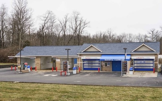


This Property Is For Sale
NEARBY LISTINGS FOR SALE OR LEASE
-
-
View all Batavia listings for sale on LoopNet.com
Property Detail
1020 Hospital Dr
01-20-11C-001
Grays Military Survey No 1116
Carwash
BATAVIA CAR WASH; OIL CHANGE (1012 HOSPITAL DRIVE)
X
Clermont
39025C0235G
Ohio
2024
0.91 AC
2024
Outlying Cincinnati East
041002
Cincinnati/Dayton
2,800 SF
Cincinnati, OH-KY-IN
DEMOGRAPHICS near 1020 Hospital Dr
1 Mile
3 Mile
5 Mile
2024 Total Population
2,238
11,418
33,860
2029 Population
2,294
11,715
34,843
Pop Growth 2024-2029
+ 2.50%
+ 2.60%
+ 2.90%
Average Age
41
39
40
2024 Total Households
799
4,160
12,680
HH Growth 2024-2029
+ 2.63%
+ 2.67%
+ 2.96%
Median Household Inc
$84,405
$66,116
$67,309
Avg Household Size
2.70
2.60
2.60
2024 Avg HH Vehicles
2.00
2.00
2.00
Median Home Value
$252,795
$204,707
$234,309
Median Year Built
1990
1984
1991
Nearby Places
Map Layers
Map Styles
 Street
 Aerial
- Restaurants
- Banks
- Shops
- Fitness
- Groceries
PUBLIC TRANSPORTATION
AIRPORT
Cincinnati/Northern Kentucky International
DRIVE
WALK
Distance
Cincinnati/Northern Kentucky International
50 min
34.1 mi
Freight Ports
Port of Toledo
DRIVE
WALK
Distance
Port of Toledo
254 min
217.4 mi
Nearby Properties
Address
Land Use
TOTAL SIZE
Lot Size
Zoning
Address
Land Use
TOTAL SIZE
Lot Size
Zoning
Address
Land Use
TOTAL SIZE
Lot Size
Zoning
58.36 AC
Address
Land Use
TOTAL SIZE
Lot Size
Zoning
23,380 SF
91.85 AC
Address
Land Use
TOTAL SIZE
Lot Size
Zoning
11,636 SF
49.40 AC
Address
Land Use
TOTAL SIZE
Lot Size
Zoning
973,058 SF
61.50 AC
Address
Land Use
TOTAL SIZE
Lot Size
Zoning
11,215 SF
20.57 AC
Address
Land Use
TOTAL SIZE
Lot Size
Zoning
20,468 SF
143.20 AC
Address
Land Use
TOTAL SIZE
Lot Size
Zoning
Address
Land Use
TOTAL SIZE
Lot Size
Zoning
Address
Land Use
TOTAL SIZE
Lot Size
Zoning
11,566 SF
28.70 AC
Address
Land Use
TOTAL SIZE
Lot Size
Zoning
26,263 SF
49.43 AC
Address
Land Use
TOTAL SIZE
Lot Size
Zoning
115,094 SF
18.53 AC
Address
Land Use
TOTAL SIZE
Lot Size
Zoning
494,336 SF
65.71 AC
Address
Land Use
TOTAL SIZE
Lot Size
Zoning
6,987 SF
80.44 AC
Address
Land Use
TOTAL SIZE
Lot Size
Zoning
17,253 SF
10.59 AC
Address
Land Use
TOTAL SIZE
Lot Size
Zoning
Address
Land Use
TOTAL SIZE
Lot Size
Zoning
30,540 SF
20.57 AC
Address
Land Use
TOTAL SIZE
Lot Size
Zoning
481,944 SF
23.27 AC
Address
Land Use
TOTAL SIZE
Lot Size
Zoning
35,046 SF
0.76 AC
Address
Land Use
TOTAL SIZE
Lot Size
Zoning
2,688 SF
16.09 AC
Address
Land Use
TOTAL SIZE
Lot Size
Zoning
8,144 SF
41.50 AC
Address
Land Use
TOTAL SIZE
Lot Size
Zoning
5,712 SF
10.76 AC
Address
Land Use
TOTAL SIZE
Lot Size
Zoning
4,812 SF
14.08 AC
Address
Land Use
TOTAL SIZE
Lot Size
Zoning
158,700 SF
31.20 AC
Address
Land Use
TOTAL SIZE
Lot Size
Zoning
5,712 SF
10.76 AC
Address
Land Use
TOTAL SIZE
Lot Size
Zoning
2,856 SF
36.20 AC
Address
Land Use
TOTAL SIZE
Lot Size
Zoning
11.05 AC
Address
Land Use
TOTAL SIZE
Lot Size
Zoning
228,888 SF
20.10 AC
Address
Land Use
TOTAL SIZE
Lot Size
Zoning
81,672 SF
10.57 AC
Address
Land Use
TOTAL SIZE
Lot Size
Zoning
13,272 SF
1.06 AC
The World's #1 Commercial Real Estate Marketplace
Connect with us
© 2025 CoStar Group
The information above has been obtained from sources believed reliable. While we do not doubt its accuracy we have not verified it and make no guarantee, warranty or representation about it. It is your responsibility to independently confirm its accuracy and completeness. Any projections, opinions, assumptions, or estimates used are for example only and do not represent the current or future performance of the property. The value of this transaction to you depends on tax and other factors which should be evaluated by your tax, financial, and legal advisors. You and your advisors should conduct a careful, independent investigation of the property to determine to your satisfaction the suitability of the property for your needs.