Property Record
1012 W Baptist Rd, Monument, CO 80132
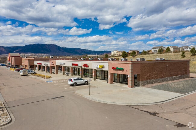


Property Detail
1012 W Baptist Rd
71253-01-001
LOT 1 JACKSON CREEK CROSSING
Commercialbuilding
EL PASO
PCD
Colorado
B and X Area of moderate flood hazard, usually the area between the limits of the 100-year and 500-year floods.
1
2024
10.62 AC
2025
Northeast
007401
Colorado Springs
86,779 SF
Colorado Springs, CO
NEARBY LISTINGS FOR SALE OR LEASE
DEMOGRAPHICS near 1012 W Baptist Rd
1 mile
3 mile
5 mile
2025 Total Population
5,169
30,316
58,191
2030 Population
5,360
31,315
59,935
Pop Growth 2025-2030
+ 3.70%
+ 3.30%
+ 3.00%
Average Age
39
41
41
2025 Total Households
1,798
10,705
20,712
HH Growth 2025-2030
+ 3.95%
+ 3.53%
+ 3.28%
Median Household Inc
$165,425
$148,037
$148,338
Avg Household Size
2.90
2.80
2.80
2025 Avg HH Vehicles
2.00
2.00
2.00
Median Home Value
$713,315
$718,415
$746,818
Median Year Built
2007
2002
2003
Nearby Places
Map Layers
Map Styles
 Street
 Aerial
Layers
 Traffic
 Biking
Places
Listings with unknown addresses are not visible on the map
- Restaurants
- Banks
- Shops
- Fitness
- Groceries
PUBLIC TRANSPORTATION
AIRPORT
City of Colorado Springs Municipal
Drive
Walk
Distance
City of Colorado Springs Municipal
36 min
24.0 mi
Freight Ports
Tulsa Port Of Catoosa
Drive
Walk
Distance
Tulsa Port Of Catoosa
745 min
699.0 mi
SALE & LEASE HISTORY
LISTING DATE
SALE/LEASE

Feb 23, 2023
For Sale
Nearby Properties
Address
Land Use
TOTAL SIZE
Lot Size
Zoning
Address
Land Use
TOTAL SIZE
Lot Size
Zoning
136,906 SF
25.22 AC
PRD-4
Address
Land Use
TOTAL SIZE
Lot Size
Zoning
112,266 SF
0.24 AC
RR3
Address
Land Use
TOTAL SIZE
Lot Size
Zoning
57,619 SF
3.26 AC
SFD-2
Address
Land Use
TOTAL SIZE
Lot Size
Zoning
10,000 SF
23.39 AC
PUD
Address
Land Use
TOTAL SIZE
Lot Size
Zoning
45,186 SF
8.91 AC
PUD
Address
Land Use
TOTAL SIZE
Lot Size
Zoning
22,970 SF
5.45 AC
PUD
Address
Land Use
TOTAL SIZE
Lot Size
Zoning
49,258 SF
3.68 AC
PUD
Address
Land Use
TOTAL SIZE
Lot Size
Zoning
154,703 SF
14.29 AC
BP HR
Address
Land Use
TOTAL SIZE
Lot Size
Zoning
53,026 SF
17.20 AC
RR-5
Address
Land Use
TOTAL SIZE
Lot Size
Zoning
23,378 SF
3.34 AC
PUD
Address
Land Use
TOTAL SIZE
Lot Size
Zoning
222,850 SF
20.55 AC
PUD
Address
Land Use
TOTAL SIZE
Lot Size
Zoning
21,695 SF
1.17 AC
BP
Address
Land Use
TOTAL SIZE
Lot Size
Zoning
347,470 SF
15.42 AC
PDZ HR
Address
Land Use
TOTAL SIZE
Lot Size
Zoning
51,034 SF
11.01 AC
PDZ HR
Address
Land Use
TOTAL SIZE
Lot Size
Zoning
119,596 SF
19.25 AC
PDZ HR
Address
Land Use
TOTAL SIZE
Lot Size
Zoning
98,428 SF
16.92 AC
PUD
Address
Land Use
TOTAL SIZE
Lot Size
Zoning
150,335 SF
28 AC
LI
Address
Land Use
TOTAL SIZE
Lot Size
Zoning
13.14 AC
PUD
Address
Land Use
TOTAL SIZE
Lot Size
Zoning
12,167 SF
1.40 AC
DB
Address
Land Use
TOTAL SIZE
Lot Size
Zoning
272.98 AC
RR-5
Address
Land Use
TOTAL SIZE
Lot Size
Zoning
17,655 SF
7.01 AC
R-4
Address
Land Use
TOTAL SIZE
Lot Size
Zoning
14,684 SF
5 AC
RS-20000
Address
Land Use
TOTAL SIZE
Lot Size
Zoning
16,235 SF
6.08 AC
RR-5
Address
Land Use
TOTAL SIZE
Lot Size
Zoning
9.62 AC
PID
Address
Land Use
TOTAL SIZE
Lot Size
Zoning
16,230 SF
2.81 AC
Address
Land Use
TOTAL SIZE
Lot Size
Zoning
222,866 SF
14.40 AC
RM-30
Address
Land Use
TOTAL SIZE
Lot Size
Zoning
198,725 SF
10.39 AC
PUD
Address
Land Use
TOTAL SIZE
Lot Size
Zoning
179,346 SF
9.88 AC
PUD
Address
Land Use
TOTAL SIZE
Lot Size
Zoning
53,337 SF
12 AC
PCD
The World's #1 Commercial Real Estate Marketplace
Connect with us
© 2026 CoStar Group
The information above has been obtained from sources believed reliable. While we do not doubt its accuracy we have not verified it and make no guarantee, warranty or representation about it. It is your responsibility to independently confirm its accuracy and completeness. Any projections, opinions, assumptions, or estimates used are for example only and do not represent the current or future performance of the property. The value of this transaction to you depends on tax and other factors which should be evaluated by your tax, financial, and legal advisors. You and your advisors should conduct a careful, independent investigation of the property to determine to your satisfaction the suitability of the property for your needs.