Property Record
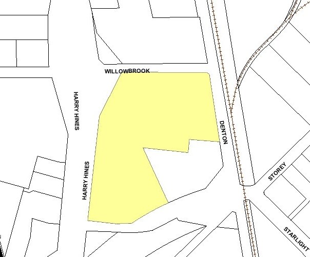
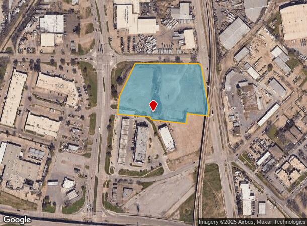
10120 Harry Hines Blvd, Dallas, TX 75220
NEARBY LISTINGS FOR SALE OR LEASE
Property Detail
10120 Harry Hines Blvd
Dallas-Fort Worth-Arlington, TX
A Smith Survey Abstract #1347
00000434077000000
BLK 5794 TR 8A ACS 4.263 INT201800091838 DD04042018 CO-DC 5794 000 08A00 1DA5794 000
Commercialacreage
Dallas
X
Texas
48113C0310J
8a
2024
4.26 AC
2025
East Hines North
009900
Dallas/Ft Worth
DEMOGRAPHICS near 10120 Harry Hines Blvd
1 Mile
3 Mile
5 Mile
2024 Total Population
16,685
71,259
247,546
2029 Population
16,651
71,208
247,885
Pop Growth 2024-2029
(0.20%)
(0.07%)
+ 0.14%
Average Age
31
35
37
2024 Total Households
5,788
25,350
99,060
HH Growth 2024-2029
(0.41%)
(0.10%)
+ 0.27%
Median Household Inc
$39,821
$62,410
$74,645
Avg Household Size
2.80
2.70
2.40
2024 Avg HH Vehicles
1.00
2.00
2.00
Median Home Value
$251,438
$375,231
$421,695
Median Year Built
1978
1970
1981
Nearby Places
Map Layers
Map Styles
 Street
 Aerial
- Restaurants
- Banks
- Shops
- Fitness
- Groceries
PUBLIC TRANSPORTATION
TRANSIT/SUBWAY
Bachman Station (DART LIGHT RAIL - GREEN LINE - Dallas Area Rapid Transit (DART), DART LIGHT RAIL - ORANGE LINE - Dallas Area Rapid Transit (DART), Green Line - Dallas Area Rapid Transit (DART), Orange Line - Dallas Area Rapid Transit (DART))
DRIVE
WALK
Distance
Bachman Station (DART LIGHT RAIL - GREEN LINE - Dallas Area Rapid Transit (DART), DART LIGHT RAIL - ORANGE LINE - Dallas Area Rapid Transit (DART), Green Line - Dallas Area Rapid Transit (DART), Orange Line - Dallas Area Rapid Transit (DART))
3 min
11 min
0.6 mi
COMMUTER RAIL
Medical/Market Ctr Station (TRINITY RAILWAY - Dallas Area Rapid Transit (DART))
DRIVE
WALK
Distance
Medical/Market Ctr Station (TRINITY RAILWAY - Dallas Area Rapid Transit (DART))
9 min
5.6 mi
Medical/Market Center (Trinity Railway Express - Dallas Area Rapid Transit (DART))
DRIVE
WALK
Distance
Medical/Market Center (Trinity Railway Express - Dallas Area Rapid Transit (DART))
9 min
5.6 mi
AIRPORT
Dallas Love Field
DRIVE
WALK
Distance
Dallas Love Field
10 min
4.6 mi
Dallas-Fort Worth International
DRIVE
WALK
Distance
Dallas-Fort Worth International
20 min
14.0 mi
Freight Ports
Port of Shreveport
DRIVE
WALK
Distance
Port of Shreveport
224 min
205.7 mi
Nearby Properties
Address
Land Use
TOTAL SIZE
Lot Size
Zoning
Address
Land Use
TOTAL SIZE
Lot Size
Zoning
2,476 SF
1,203.03 AC
Z116
Address
Land Use
TOTAL SIZE
Lot Size
Zoning
4,407,366 SF
1,300 AC
IR
Address
Land Use
TOTAL SIZE
Lot Size
Zoning
450,131 SF
39.95 AC
Z296
Address
Land Use
TOTAL SIZE
Lot Size
Zoning
30,000 SF
78.01 AC
Z392
Address
Land Use
TOTAL SIZE
Lot Size
Zoning
1,898,977 SF
42.38 AC
Z239
Address
Land Use
TOTAL SIZE
Lot Size
Zoning
729,266 SF
10.20 AC
Z239
Address
Land Use
TOTAL SIZE
Lot Size
Zoning
654,829 SF
9.78 AC
Z243
Address
Land Use
TOTAL SIZE
Lot Size
Zoning
608,308 SF
7.26 AC
Z198
Address
Land Use
TOTAL SIZE
Lot Size
Zoning
618,535 SF
1,300 AC
IR
Address
Land Use
TOTAL SIZE
Lot Size
Zoning
641,711 SF
5.38 AC
Z239
Address
Land Use
TOTAL SIZE
Lot Size
Zoning
253,580 SF
188.04 AC
Z393
Address
Land Use
TOTAL SIZE
Lot Size
Zoning
529,640 SF
5.13 AC
Z393
Address
Land Use
TOTAL SIZE
Lot Size
Zoning
507,008 SF
5.07 AC
Z239
Address
Land Use
TOTAL SIZE
Lot Size
Zoning
533,342 SF
5.86 AC
Z239
Address
Land Use
TOTAL SIZE
Lot Size
Zoning
685,774 SF
7.36 AC
Z198
Address
Land Use
TOTAL SIZE
Lot Size
Zoning
621,941 SF
10.53 AC
Z239
Address
Land Use
TOTAL SIZE
Lot Size
Zoning
174,728 SF
223.82 AC
Z298
Address
Land Use
TOTAL SIZE
Lot Size
Zoning
205,992 SF
21.48 AC
Z239
Address
Land Use
TOTAL SIZE
Lot Size
Zoning
343,192 SF
14.99 AC
Z151
Address
Land Use
TOTAL SIZE
Lot Size
Zoning
1,102,000 SF
4.98 AC
Z393
Address
Land Use
TOTAL SIZE
Lot Size
Zoning
388,822 SF
19.97 AC
Z116
Address
Land Use
TOTAL SIZE
Lot Size
Zoning
310,154 SF
10.33 AC
Z393
Address
Land Use
TOTAL SIZE
Lot Size
Zoning
165,600 SF
6.78 AC
Z296
Address
Land Use
TOTAL SIZE
Lot Size
Zoning
348,013 SF
11.09 AC
Z243
Address
Land Use
TOTAL SIZE
Lot Size
Zoning
320,841 SF
12.64 AC
Z59
Address
Land Use
TOTAL SIZE
Lot Size
Zoning
404,096 SF
12.76 AC
Z239
Address
Land Use
TOTAL SIZE
Lot Size
Zoning
178,900 SF
15.93 AC
Z164
Address
Land Use
TOTAL SIZE
Lot Size
Zoning
329,373 SF
14.98 AC
Z125
Address
Land Use
TOTAL SIZE
Lot Size
Zoning
134,265 SF
29.20 AC
Z116
Address
Land Use
TOTAL SIZE
Lot Size
Zoning
659,704 SF
11.55 AC
Z393
The World's #1 Commercial Real Estate Marketplace
Connect with us
© 2025 CoStar Group
The information above has been obtained from sources believed reliable. While we do not doubt its accuracy we have not verified it and make no guarantee, warranty or representation about it. It is your responsibility to independently confirm its accuracy and completeness. Any projections, opinions, assumptions, or estimates used are for example only and do not represent the current or future performance of the property. The value of this transaction to you depends on tax and other factors which should be evaluated by your tax, financial, and legal advisors. You and your advisors should conduct a careful, independent investigation of the property to determine to your satisfaction the suitability of the property for your needs.