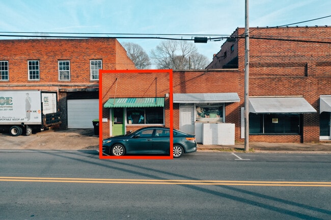
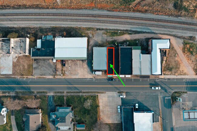
Property Record
1013 S Main St, China Grove, NC 28023

Property Detail
1013 S Main St
Storebuilding
Rowan
HB:HIGHWAY
North Carolina
B and X Area of moderate flood hazard, usually the area between the limits of the 100-year and 500-year floods.
0.05 AC
2025
Rowan County
2025
Charlotte
051700
Charlotte-Concord-Gastonia, NC-SC
990 SF
104-114A
NEARBY LISTINGS FOR SALE OR LEASE
DEMOGRAPHICS near 1013 S Main St
1 mile
3 mile
5 mile
2025 Total Population
3,681
17,054
47,522
2030 Population
3,856
17,877
49,884
Pop Growth 2025-2030
+ 4.75%
+ 4.83%
+ 4.97%
Average Age
40
41
40
2025 Total Households
1,479
6,753
18,266
HH Growth 2025-2030
+ 4.94%
+ 4.96%
+ 5.14%
Median Household Inc
$58,461
$59,661
$65,739
Avg Household Size
2.50
2.50
2.50
2025 Avg HH Vehicles
2.00
2.00
2.00
Median Home Value
$236,993
$256,933
$255,969
Median Year Built
1973
1980
1982
Nearby Places
Map Layers
Map Styles
 Street
 Aerial
Layers
 Traffic
 Biking
Places
Listings with unknown addresses are not visible on the map
- Restaurants
- Banks
- Shops
- Fitness
- Groceries
PUBLIC TRANSPORTATION
COMMUTER RAIL
Kannapolis Station (Piedmont - North Carolina by Train (NC Train))
Drive
Walk
Distance
Kannapolis Station (Piedmont - North Carolina by Train (NC Train))
11 min
5.8 mi
AIRPORT
Concord-Padgett Regional
Drive
Walk
Distance
Concord-Padgett Regional
31 min
18.4 mi
Charlotte/Douglas International
Drive
Walk
Distance
Charlotte/Douglas International
57 min
38.7 mi
SALE & LEASE HISTORY
LISTING DATE
SALE/LEASE

Feb 26, 2020
For Sale
Nearby Properties
Address
Land Use
TOTAL SIZE
Lot Size
Zoning
Address
Land Use
TOTAL SIZE
Lot Size
Zoning
1,806 SF
197.72 AC
Address
Land Use
TOTAL SIZE
Lot Size
Zoning
728,000 SF
51.80 AC
Address
Land Use
TOTAL SIZE
Lot Size
Zoning
32,128 SF
16.30 AC
R3:SINGLE
Address
Land Use
TOTAL SIZE
Lot Size
Zoning
231,232 SF
41.58 AC
Address
Land Use
TOTAL SIZE
Lot Size
Zoning
55,888 SF
39.43 AC
Address
Land Use
TOTAL SIZE
Lot Size
Zoning
230,000 SF
55.37 AC
Address
Land Use
TOTAL SIZE
Lot Size
Zoning
269,700 SF
76.24 AC
Address
Land Use
TOTAL SIZE
Lot Size
Zoning
35,850 SF
34 AC
Address
Land Use
TOTAL SIZE
Lot Size
Zoning
21,906 SF
7.50 AC
OI:OFFICE
Address
Land Use
TOTAL SIZE
Lot Size
Zoning
146,346 SF
16.39 AC
Address
Land Use
TOTAL SIZE
Lot Size
Zoning
58,300 SF
14.53 AC
R8:SINGLE
Address
Land Use
TOTAL SIZE
Lot Size
Zoning
19,951 SF
9.12 AC
OI:OFFICE
Address
Land Use
TOTAL SIZE
Lot Size
Zoning
43,091 SF
21.39 AC
Address
Land Use
TOTAL SIZE
Lot Size
Zoning
139,812 SF
17.35 AC
Address
Land Use
TOTAL SIZE
Lot Size
Zoning
8,941 SF
2.36 AC
Address
Land Use
TOTAL SIZE
Lot Size
Zoning
1,640 SF
21.46 AC
Address
Land Use
TOTAL SIZE
Lot Size
Zoning
36,092 SF
3.67 AC
Address
Land Use
TOTAL SIZE
Lot Size
Zoning
30,284 SF
12.51 AC
Address
Land Use
TOTAL SIZE
Lot Size
Zoning
45,450 SF
5.01 AC
C2:HIGHWAY
Address
Land Use
TOTAL SIZE
Lot Size
Zoning
27,467 SF
52.01 AC
R1:SINGLE
Address
Land Use
TOTAL SIZE
Lot Size
Zoning
17,259 SF
0.90 AC
Address
Land Use
TOTAL SIZE
Lot Size
Zoning
2,552 SF
80.44 AC
Address
Land Use
TOTAL SIZE
Lot Size
Zoning
17,045 SF
6.60 AC
Address
Land Use
TOTAL SIZE
Lot Size
Zoning
40,162 SF
7.28 AC
HB:HIGHWAY
Address
Land Use
TOTAL SIZE
Lot Size
Zoning
12,977 SF
2.98 AC
Address
Land Use
TOTAL SIZE
Lot Size
Zoning
17,467 SF
3.16 AC
OI:OFFICE
Address
Land Use
TOTAL SIZE
Lot Size
Zoning
11,970 SF
1.37 AC
CB:CENTRAL
Address
Land Use
TOTAL SIZE
Lot Size
Zoning
7,500 SF
3.96 AC
C2:HIGHWAY
Address
Land Use
TOTAL SIZE
Lot Size
Zoning
24,565 SF
1.19 AC
Address
Land Use
TOTAL SIZE
Lot Size
Zoning
12,030 SF
2.08 AC
HB:HIGHWAY
The World's #1 Commercial Real Estate Marketplace
Connect with us
© 2026 CoStar Group
The information above has been obtained from sources believed reliable. While we do not doubt its accuracy we have not verified it and make no guarantee, warranty or representation about it. It is your responsibility to independently confirm its accuracy and completeness. Any projections, opinions, assumptions, or estimates used are for example only and do not represent the current or future performance of the property. The value of this transaction to you depends on tax and other factors which should be evaluated by your tax, financial, and legal advisors. You and your advisors should conduct a careful, independent investigation of the property to determine to your satisfaction the suitability of the property for your needs.