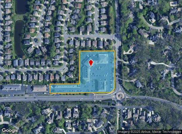
Property Record
10130 Brooks School Rd, Fishers, IN 46037

NEARBY LISTINGS FOR SALE OR LEASE
Property Detail
10130 Brooks School Rd
Indianapolis-Carmel-Greenwood, IN
Lakeview Addition
29-15-10-000-023.000-020
ACREAGE 4.59, SECTION 10, TOWNSHIP 17, RANGE 5, LAKEVIEW ADDITION, LOT 9, 10, 11, 12, 13, 14, 15, 16 & ACREAGE
Regionalshoppingcenterormallwithanchorstore
Hamilton
X
Indiana
18097C0087F
9,10
2023
4.59 AC
2024
Fishers/Geist
110822
Indianapolis
58,252 SF
DEMOGRAPHICS near 10130 Brooks School Rd
1 Mile
3 Mile
5 Mile
2024 Total Population
3,759
60,471
150,177
2029 Population
4,162
66,003
163,770
Pop Growth 2024-2029
+ 10.72%
+ 9.15%
+ 9.05%
Average Age
40
38
38
2024 Total Households
1,295
20,742
54,135
HH Growth 2024-2029
+ 10.66%
+ 8.73%
+ 8.76%
Median Household Inc
$181,353
$142,214
$111,676
Avg Household Size
2.90
2.90
2.70
2024 Avg HH Vehicles
2.00
2.00
2.00
Median Home Value
$601,036
$361,369
$307,462
Median Year Built
1996
2000
2000
Nearby Places
Map Layers
Map Styles
 Street
 Aerial
- Restaurants
- Banks
- Shops
- Fitness
- Groceries
PUBLIC TRANSPORTATION
AIRPORT
Indianapolis International
DRIVE
WALK
Distance
Indianapolis International
48 min
35.6 mi
Freight Ports
Virginia Port Authority - Richmond
DRIVE
WALK
Distance
Virginia Port Authority - Richmond
1 min
490.5 mi
SALE & LEASE HISTORY
LISTING DATE
SALE/LEASE

Sep 26, 2017
For Lease
Sep 25, 2016
For Lease
Mar 04, 2025
For Lease
Aug 01, 2025
For Lease
Nearby Properties
Address
Land Use
TOTAL SIZE
Lot Size
Zoning
Address
Land Use
TOTAL SIZE
Lot Size
Zoning
286,120 SF
8.03 AC
Address
Land Use
TOTAL SIZE
Lot Size
Zoning
321,878 SF
14.81 AC
Address
Land Use
TOTAL SIZE
Lot Size
Zoning
140,987 SF
13.99 AC
Address
Land Use
TOTAL SIZE
Lot Size
Zoning
94,472 SF
15.91 AC
Address
Land Use
TOTAL SIZE
Lot Size
Zoning
224,860 SF
18.52 AC
Address
Land Use
TOTAL SIZE
Lot Size
Zoning
188,840 SF
10.49 AC
Address
Land Use
TOTAL SIZE
Lot Size
Zoning
241,325 SF
26 AC
Address
Land Use
TOTAL SIZE
Lot Size
Zoning
120,839 SF
Address
Land Use
TOTAL SIZE
Lot Size
Zoning
643,957 SF
34.93 AC
Address
Land Use
TOTAL SIZE
Lot Size
Zoning
1,769 SF
18.27 AC
Address
Land Use
TOTAL SIZE
Lot Size
Zoning
87,125 SF
7.40 AC
Address
Land Use
TOTAL SIZE
Lot Size
Zoning
67,674 SF
24.91 AC
Address
Land Use
TOTAL SIZE
Lot Size
Zoning
88,772 SF
20.05 AC
Address
Land Use
TOTAL SIZE
Lot Size
Zoning
107,364 SF
29.96 AC
Address
Land Use
TOTAL SIZE
Lot Size
Zoning
141,781 SF
12.23 AC
Address
Land Use
TOTAL SIZE
Lot Size
Zoning
75,806 SF
9.35 AC
Address
Land Use
TOTAL SIZE
Lot Size
Zoning
117,517 SF
1.78 AC
Address
Land Use
TOTAL SIZE
Lot Size
Zoning
28,144 SF
10.70 AC
Address
Land Use
TOTAL SIZE
Lot Size
Zoning
124,410 SF
15.48 AC
Address
Land Use
TOTAL SIZE
Lot Size
Zoning
95,082 SF
2.12 AC
Address
Land Use
TOTAL SIZE
Lot Size
Zoning
64,445 SF
11.19 AC
Address
Land Use
TOTAL SIZE
Lot Size
Zoning
67,241 SF
172.37 AC
Address
Land Use
TOTAL SIZE
Lot Size
Zoning
94,796 SF
15.17 AC
Address
Land Use
TOTAL SIZE
Lot Size
Zoning
116,233 SF
5.29 AC
Address
Land Use
TOTAL SIZE
Lot Size
Zoning
36,094 SF
17.62 AC
Address
Land Use
TOTAL SIZE
Lot Size
Zoning
40,092 SF
8.44 AC
Address
Land Use
TOTAL SIZE
Lot Size
Zoning
31,469 SF
4.89 AC
Address
Land Use
TOTAL SIZE
Lot Size
Zoning
27,409 SF
21.91 AC
Address
Land Use
TOTAL SIZE
Lot Size
Zoning
106,277 SF
2.38 AC
Address
Land Use
TOTAL SIZE
Lot Size
Zoning
40,105 SF
10.02 AC
ZO01
The World's #1 Commercial Real Estate Marketplace
Connect with us
© 2026 CoStar Group
The information above has been obtained from sources believed reliable. While we do not doubt its accuracy we have not verified it and make no guarantee, warranty or representation about it. It is your responsibility to independently confirm its accuracy and completeness. Any projections, opinions, assumptions, or estimates used are for example only and do not represent the current or future performance of the property. The value of this transaction to you depends on tax and other factors which should be evaluated by your tax, financial, and legal advisors. You and your advisors should conduct a careful, independent investigation of the property to determine to your satisfaction the suitability of the property for your needs.