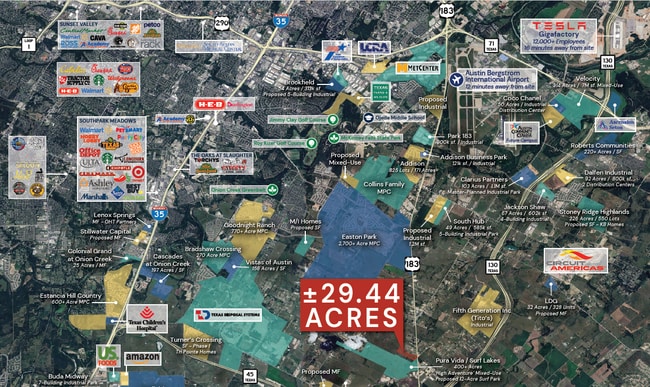
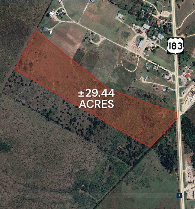
Property Record
10130 Us Highway 183 S, Austin, TX 78747

Property Detail
10130 Us Highway 183 S
Austin-Round Rock-San Marcos, TX
ABS 479 SUR 2 LEWIS W ACR 29.44
300674
TRAVIS
Farms
Texas
B and X Area of moderate flood hazard, usually the area between the limits of the 100-year and 500-year floods.
29.44 AC
2025
Southeast
2025
Austin
002432
NEARBY LISTINGS FOR SALE OR LEASE
DEMOGRAPHICS near 10130 Us Highway 183 S
1 mile
3 mile
5 mile
2025 Total Population
357
4,197
28,634
2030 Population
374
4,486
31,229
Pop Growth 2025-2030
+ 4.76%
+ 6.89%
+ 9.06%
Average Age
37
37
36
2025 Total Households
101
1,205
9,025
HH Growth 2025-2030
+ 4.95%
+ 7.72%
+ 9.98%
Median Household Inc
$56,904
$67,758
$93,530
Avg Household Size
3.30
3.30
3.10
2025 Avg HH Vehicles
3.00
2.00
2.00
Median Home Value
$469,999
$477,192
$434,644
Median Year Built
1995
2001
2010
Nearby Places
Map Layers
Map Styles
 Street
 Aerial
Layers
 Traffic
 Biking
Places
Listings with unknown addresses are not visible on the map
- Restaurants
- Banks
- Shops
- Fitness
- Groceries
PUBLIC TRANSPORTATION
AIRPORT
Austin-Bergstrom International
Drive
Walk
Distance
Austin-Bergstrom International
17 min
9.0 mi
Freight Ports
Calhoun Port
Drive
Walk
Distance
Calhoun Port
168 min
141.1 mi
SALE & LEASE HISTORY
LISTING DATE
SALE/LEASE

Oct 04, 2023
For Sale
Nearby Properties
Address
Land Use
TOTAL SIZE
Lot Size
Zoning
Address
Land Use
TOTAL SIZE
Lot Size
Zoning
562,830 SF
213.88 AC
Address
Land Use
TOTAL SIZE
Lot Size
Zoning
356,800 SF
40.79 AC
Address
Land Use
TOTAL SIZE
Lot Size
Zoning
218,400 SF
13.89 AC
Address
Land Use
TOTAL SIZE
Lot Size
Zoning
72,159 SF
Address
Land Use
TOTAL SIZE
Lot Size
Zoning
57,100 SF
Address
Land Use
TOTAL SIZE
Lot Size
Zoning
4,060 SF
154.80 AC
Address
Land Use
TOTAL SIZE
Lot Size
Zoning
44,402 SF
Address
Land Use
TOTAL SIZE
Lot Size
Zoning
48,000 SF
10.05 AC
Address
Land Use
TOTAL SIZE
Lot Size
Zoning
24,400 SF
5.56 AC
Address
Land Use
TOTAL SIZE
Lot Size
Zoning
164.65 AC
Address
Land Use
TOTAL SIZE
Lot Size
Zoning
34,500 SF
3 AC
Address
Land Use
TOTAL SIZE
Lot Size
Zoning
14,500 SF
10.97 AC
Address
Land Use
TOTAL SIZE
Lot Size
Zoning
14,140 SF
10 AC
Address
Land Use
TOTAL SIZE
Lot Size
Zoning
22,400 SF
25.25 AC
Address
Land Use
TOTAL SIZE
Lot Size
Zoning
34,425 SF
3.84 AC
Address
Land Use
TOTAL SIZE
Lot Size
Zoning
5,150 SF
10 AC
Address
Land Use
TOTAL SIZE
Lot Size
Zoning
16,943 SF
11.74 AC
Address
Land Use
TOTAL SIZE
Lot Size
Zoning
17,500 SF
1.93 AC
Address
Land Use
TOTAL SIZE
Lot Size
Zoning
20,000 SF
2.21 AC
Address
Land Use
TOTAL SIZE
Lot Size
Zoning
4.29 AC
Address
Land Use
TOTAL SIZE
Lot Size
Zoning
24,000 SF
16.52 AC
Address
Land Use
TOTAL SIZE
Lot Size
Zoning
35.73 AC
Address
Land Use
TOTAL SIZE
Lot Size
Zoning
45.93 AC
Address
Land Use
TOTAL SIZE
Lot Size
Zoning
816 SF
39.90 AC
Address
Land Use
TOTAL SIZE
Lot Size
Zoning
4,800 SF
18 AC
Address
Land Use
TOTAL SIZE
Lot Size
Zoning
22,627 SF
11.22 AC
Address
Land Use
TOTAL SIZE
Lot Size
Zoning
12,400 SF
23.99 AC
Address
Land Use
TOTAL SIZE
Lot Size
Zoning
118.71 AC
Address
Land Use
TOTAL SIZE
Lot Size
Zoning
11,601 SF
5.32 AC
Address
Land Use
TOTAL SIZE
Lot Size
Zoning
1,872 SF
76.94 AC
The World's #1 Commercial Real Estate Marketplace
Connect with us
© 2026 CoStar Group
The information above has been obtained from sources believed reliable. While we do not doubt its accuracy we have not verified it and make no guarantee, warranty or representation about it. It is your responsibility to independently confirm its accuracy and completeness. Any projections, opinions, assumptions, or estimates used are for example only and do not represent the current or future performance of the property. The value of this transaction to you depends on tax and other factors which should be evaluated by your tax, financial, and legal advisors. You and your advisors should conduct a careful, independent investigation of the property to determine to your satisfaction the suitability of the property for your needs.