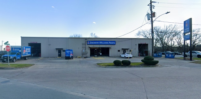
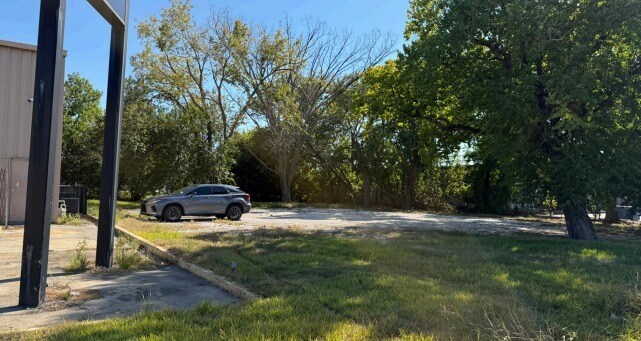
Property Record
10116 Buxton St, Houston, TX 77017
Current Lease Availabilities
NEARBY LISTINGS FOR SALE OR LEASE
Property Detail
10116 Buxton St
Houston-The Woodlands-Sugar Land, TX
Allendale Townsite Sec A
0600510000035
LT 35 ALLENDALE TOWNSITE SEC A
Vacantlandnec
Harris
X
Texas
48201C0905N
35
2024
0.16 AC
2025
Southeast Outer Loop
320500
Houston
DEMOGRAPHICS near 10116 Buxton St
1 Mile
3 Mile
5 Mile
2024 Total Population
4,038
105,106
311,074
2029 Population
4,084
107,946
318,665
Pop Growth 2024-2029
+ 1.14%
+ 2.70%
+ 2.44%
Average Age
37
35
35
2024 Total Households
1,090
32,845
100,297
HH Growth 2024-2029
+ 1.10%
+ 2.80%
+ 2.47%
Median Household Inc
$71,284
$44,957
$44,302
Avg Household Size
3.60
3.10
3.00
2024 Avg HH Vehicles
3.00
2.00
2.00
Median Home Value
$144,823
$123,708
$134,741
Median Year Built
1956
1960
1964
Nearby Places
Map Layers
Map Styles
 Street
 Aerial
- Restaurants
- Banks
- Shops
- Fitness
- Groceries
PUBLIC TRANSPORTATION
AIRPORT
William P Hobby
DRIVE
WALK
Distance
William P Hobby
18 min
8.7 mi
George Bush Intcntl/Houston
DRIVE
WALK
Distance
George Bush Intcntl/Houston
35 min
26.1 mi
Freight Ports
Port of Houston
DRIVE
WALK
Distance
Port of Houston
10 min
4.5 mi
Nearby Properties
Address
Land Use
TOTAL SIZE
Lot Size
Zoning
Address
Land Use
TOTAL SIZE
Lot Size
Zoning
65.22 AC
Address
Land Use
TOTAL SIZE
Lot Size
Zoning
256.70 AC
Address
Land Use
TOTAL SIZE
Lot Size
Zoning
108.84 AC
Address
Land Use
TOTAL SIZE
Lot Size
Zoning
134.46 AC
Address
Land Use
TOTAL SIZE
Lot Size
Zoning
4,574,044 SF
102.55 AC
Address
Land Use
TOTAL SIZE
Lot Size
Zoning
1,970,716 SF
118.84 AC
Address
Land Use
TOTAL SIZE
Lot Size
Zoning
592,980 SF
20 AC
Address
Land Use
TOTAL SIZE
Lot Size
Zoning
143.17 AC
Address
Land Use
TOTAL SIZE
Lot Size
Zoning
1,476,300 SF
39.05 AC
Address
Land Use
TOTAL SIZE
Lot Size
Zoning
4.26 AC
Address
Land Use
TOTAL SIZE
Lot Size
Zoning
165.53 AC
Address
Land Use
TOTAL SIZE
Lot Size
Zoning
2,275,058 SF
24.47 AC
Address
Land Use
TOTAL SIZE
Lot Size
Zoning
1,171,276 SF
44.19 AC
Address
Land Use
TOTAL SIZE
Lot Size
Zoning
115.83 AC
Address
Land Use
TOTAL SIZE
Lot Size
Zoning
2,918,000 SF
69.31 AC
Address
Land Use
TOTAL SIZE
Lot Size
Zoning
4,580,000 SF
42.82 AC
Address
Land Use
TOTAL SIZE
Lot Size
Zoning
218,787 SF
10 AC
Address
Land Use
TOTAL SIZE
Lot Size
Zoning
1,149,387 SF
36.61 AC
Address
Land Use
TOTAL SIZE
Lot Size
Zoning
33.97 AC
Address
Land Use
TOTAL SIZE
Lot Size
Zoning
504,938 SF
28.96 AC
Address
Land Use
TOTAL SIZE
Lot Size
Zoning
363,740 SF
16.92 AC
Address
Land Use
TOTAL SIZE
Lot Size
Zoning
143.17 AC
Address
Land Use
TOTAL SIZE
Lot Size
Zoning
1,113,216 SF
43.99 AC
Address
Land Use
TOTAL SIZE
Lot Size
Zoning
41.94 AC
Address
Land Use
TOTAL SIZE
Lot Size
Zoning
2,595,459 SF
32.10 AC
Address
Land Use
TOTAL SIZE
Lot Size
Zoning
188,111 SF
31.13 AC
Address
Land Use
TOTAL SIZE
Lot Size
Zoning
538,431 SF
21.31 AC
Address
Land Use
TOTAL SIZE
Lot Size
Zoning
261.10 AC
Address
Land Use
TOTAL SIZE
Lot Size
Zoning
107.07 AC
Address
Land Use
TOTAL SIZE
Lot Size
Zoning
331,196 SF
40.14 AC
The World's #1 Commercial Real Estate Marketplace
Connect with us
© 2025 CoStar Group
The information above has been obtained from sources believed reliable. While we do not doubt its accuracy we have not verified it and make no guarantee, warranty or representation about it. It is your responsibility to independently confirm its accuracy and completeness. Any projections, opinions, assumptions, or estimates used are for example only and do not represent the current or future performance of the property. The value of this transaction to you depends on tax and other factors which should be evaluated by your tax, financial, and legal advisors. You and your advisors should conduct a careful, independent investigation of the property to determine to your satisfaction the suitability of the property for your needs.