Property Record
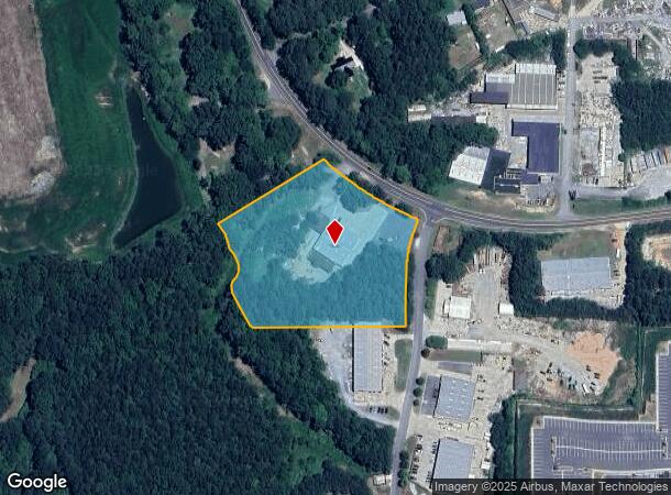
1014 N Highway 293 St Se, Cartersville, GA 30121
NEARBY LISTINGS FOR SALE OR LEASE
Property Detail
1014 N Highway 293 St Se
0096-1222-004
Com - Acworth
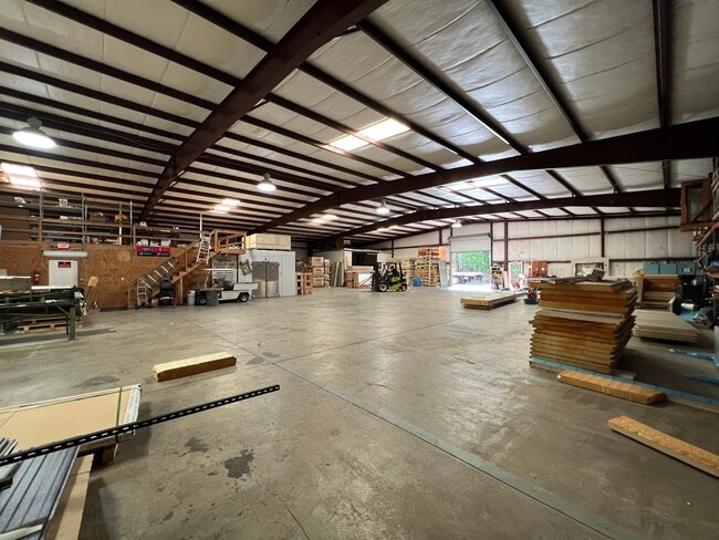
Industrialgeneral
LL1222 1223 LD21 GEORGIA COOLER & EQUIP
X
Bartow
13223C0055D
Georgia
2024
4.99 AC
2024
Kennesaw/Acworth
030108
Atlanta
672 SF
Atlanta-Sandy Springs-Roswell, GA
DEMOGRAPHICS near 1014 N Highway 293 St Se
1 Mile
3 Mile
5 Mile
2024 Total Population
956
14,827
55,727
2029 Population
1,066
16,208
60,776
Pop Growth 2024-2029
+ 11.51%
+ 9.31%
+ 9.06%
Average Age
42
41
40
2024 Total Households
368
5,312
19,826
HH Growth 2024-2029
+ 11.14%
+ 8.87%
+ 8.52%
Median Household Inc
$49,874
$89,009
$86,978
Avg Household Size
2.60
2.80
2.80
2024 Avg HH Vehicles
2.00
2.00
2.00
Median Home Value
$98,818
$320,884
$300,106
Median Year Built
1983
1996
1997
Nearby Places
Map Layers
Map Styles
 Street
 Aerial
- Restaurants
- Banks
- Shops
- Fitness
- Groceries
SALE & LEASE HISTORY
LISTING DATE
SALE/LEASE

May 23, 2023
For Sale
Nearby Properties
Address
Land Use
TOTAL SIZE
Lot Size
Zoning
Address
Land Use
TOTAL SIZE
Lot Size
Zoning
Address
Land Use
TOTAL SIZE
Lot Size
Zoning
171,050 SF
6.71 AC
Address
Land Use
TOTAL SIZE
Lot Size
Zoning
90.96 AC
Address
Land Use
TOTAL SIZE
Lot Size
Zoning
3,320 SF
78.23 AC
Address
Land Use
TOTAL SIZE
Lot Size
Zoning
61,867 SF
4 AC
Address
Land Use
TOTAL SIZE
Lot Size
Zoning
11.60 AC
IN
Address
Land Use
TOTAL SIZE
Lot Size
Zoning
71,175 SF
30.37 AC
Address
Land Use
TOTAL SIZE
Lot Size
Zoning
173,600 SF
42.94 AC
Address
Land Use
TOTAL SIZE
Lot Size
Zoning
69,376 SF
8.52 AC
GC
Address
Land Use
TOTAL SIZE
Lot Size
Zoning
3.76 AC
IN
Address
Land Use
TOTAL SIZE
Lot Size
Zoning
14.09 AC
Address
Land Use
TOTAL SIZE
Lot Size
Zoning
11,945 SF
12.96 AC
Address
Land Use
TOTAL SIZE
Lot Size
Zoning
12,112 SF
5.14 AC
Address
Land Use
TOTAL SIZE
Lot Size
Zoning
47,728 SF
5.45 AC
GC/WS
Address
Land Use
TOTAL SIZE
Lot Size
Zoning
39,464 SF
1.61 AC
Address
Land Use
TOTAL SIZE
Lot Size
Zoning
45,045 SF
2.63 AC
Address
Land Use
TOTAL SIZE
Lot Size
Zoning
1,824 SF
68.83 AC
A1
Address
Land Use
TOTAL SIZE
Lot Size
Zoning
31.69 AC
Address
Land Use
TOTAL SIZE
Lot Size
Zoning
61,857 SF
15.38 AC
C2
Address
Land Use
TOTAL SIZE
Lot Size
Zoning
133,517 SF
9.65 AC
R4
Address
Land Use
TOTAL SIZE
Lot Size
Zoning
600 SF
176.27 AC
A1
Address
Land Use
TOTAL SIZE
Lot Size
Zoning
70,010 SF
2.63 AC
C1
Address
Land Use
TOTAL SIZE
Lot Size
Zoning
Address
Land Use
TOTAL SIZE
Lot Size
Zoning
24.84 AC
Address
Land Use
TOTAL SIZE
Lot Size
Zoning
18,376 SF
5 AC
GC
Address
Land Use
TOTAL SIZE
Lot Size
Zoning
672 SF
52.57 AC
Address
Land Use
TOTAL SIZE
Lot Size
Zoning
2,968 SF
24.61 AC
A1
Address
Land Use
TOTAL SIZE
Lot Size
Zoning
15,061 SF
16.55 AC
GC
Address
Land Use
TOTAL SIZE
Lot Size
Zoning
14,490 SF
1.65 AC
GC/WS
Address
Land Use
TOTAL SIZE
Lot Size
Zoning
7.13 AC
C1
The World's #1 Commercial Real Estate Marketplace
Connect with us
© 2025 CoStar Group
The information above has been obtained from sources believed reliable. While we do not doubt its accuracy we have not verified it and make no guarantee, warranty or representation about it. It is your responsibility to independently confirm its accuracy and completeness. Any projections, opinions, assumptions, or estimates used are for example only and do not represent the current or future performance of the property. The value of this transaction to you depends on tax and other factors which should be evaluated by your tax, financial, and legal advisors. You and your advisors should conduct a careful, independent investigation of the property to determine to your satisfaction the suitability of the property for your needs.