Property Record
1014 N Main St, Kernersville, NC 27284
NEARBY LISTINGS FOR SALE OR LEASE
Property Detail
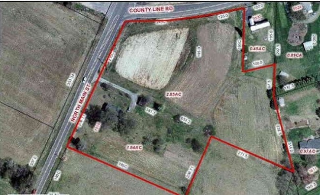
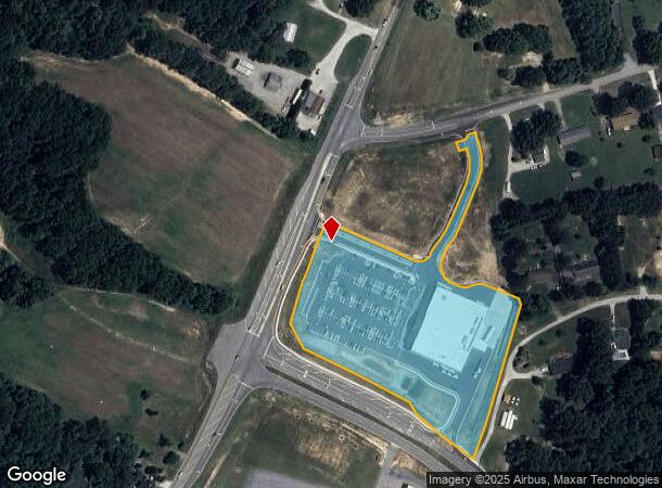
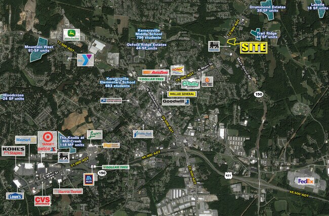
1014 N Main St
6886-99-0428
LO:441 TR:001 BL:5410 PL:77-053
Storebuilding
Forsyth
X
North Carolina
3710688600J
441
0
6.05 AC
2025
Kernersville
003202
Greensboro/Winston-Salem
36,542 SF
Winston-Salem, NC
DEMOGRAPHICS near 1014 N Main St
1 Mile
3 Mile
5 Mile
2024 Total Population
4,581
24,162
54,969
2029 Population
4,749
24,982
56,800
Pop Growth 2024-2029
+ 3.67%
+ 3.39%
+ 3.33%
Average Age
41
42
42
2024 Total Households
1,932
10,501
22,717
HH Growth 2024-2029
+ 3.67%
+ 3.49%
+ 3.42%
Median Household Inc
$55,371
$64,310
$75,300
Avg Household Size
2.30
2.30
2.40
2024 Avg HH Vehicles
2.00
2.00
2.00
Median Home Value
$167,505
$234,230
$256,330
Median Year Built
1992
1986
1991
Nearby Places
Map Layers
Map Styles
 Street
 Aerial
- Restaurants
- Banks
- Shops
- Fitness
- Groceries
PUBLIC TRANSPORTATION
AIRPORT
Piedmont Triad International
DRIVE
WALK
Distance
Piedmont Triad International
22 min
11.2 mi
Freight Ports
Virginia Port Authority - Richmond
DRIVE
WALK
Distance
Virginia Port Authority - Richmond
248 min
214.8 mi
SALE & LEASE HISTORY
LISTING DATE
SALE/LEASE

Sep 24, 2016
For Sale
Feb 16, 2024
For Lease
Nearby Properties
Address
Land Use
TOTAL SIZE
Lot Size
Zoning
Address
Land Use
TOTAL SIZE
Lot Size
Zoning
179,681 SF
38.53 AC
MBP
Address
Land Use
TOTAL SIZE
Lot Size
Zoning
1,001,670 SF
94.34 AC
BI
Address
Land Use
TOTAL SIZE
Lot Size
Zoning
667,440 SF
53.44 AC
BI
Address
Land Use
TOTAL SIZE
Lot Size
Zoning
777,963 SF
133.64 AC
BI
Address
Land Use
TOTAL SIZE
Lot Size
Zoning
576,252 SF
59.82 AC
GI,LI
Address
Land Use
TOTAL SIZE
Lot Size
Zoning
350,268 SF
30.53 AC
BI
Address
Land Use
TOTAL SIZE
Lot Size
Zoning
115,838 SF
14.41 AC
GI-C
Address
Land Use
TOTAL SIZE
Lot Size
Zoning
129,895 SF
30.33 AC
RM18
Address
Land Use
TOTAL SIZE
Lot Size
Zoning
275,040 SF
28 AC
BI
Address
Land Use
TOTAL SIZE
Lot Size
Zoning
87,741 SF
15.44 AC
RM18
Address
Land Use
TOTAL SIZE
Lot Size
Zoning
545,857 SF
51.60 AC
GI
Address
Land Use
TOTAL SIZE
Lot Size
Zoning
451.32 AC
MU-C
Address
Land Use
TOTAL SIZE
Lot Size
Zoning
258,154 SF
39.55 AC
GI
Address
Land Use
TOTAL SIZE
Lot Size
Zoning
244,562 SF
29.92 AC
BI
Address
Land Use
TOTAL SIZE
Lot Size
Zoning
277,250 SF
30.15 AC
GI
Address
Land Use
TOTAL SIZE
Lot Size
Zoning
121,981 SF
14.48 AC
HB-S
Address
Land Use
TOTAL SIZE
Lot Size
Zoning
83,774 SF
7.51 AC
GB-S
Address
Land Use
TOTAL SIZE
Lot Size
Zoning
74,608 SF
8.68 AC
MBP
Address
Land Use
TOTAL SIZE
Lot Size
Zoning
160,179 SF
23.75 AC
LI-C,RS20
Address
Land Use
TOTAL SIZE
Lot Size
Zoning
603,494 SF
48.87 AC
LI
Address
Land Use
TOTAL SIZE
Lot Size
Zoning
43,286 SF
3.77 AC
RMU-S
Address
Land Use
TOTAL SIZE
Lot Size
Zoning
94,092 SF
15.31 AC
RM18
Address
Land Use
TOTAL SIZE
Lot Size
Zoning
203,069 SF
71.34 AC
GI
Address
Land Use
TOTAL SIZE
Lot Size
Zoning
102,950 SF
21.98 AC
RS12
Address
Land Use
TOTAL SIZE
Lot Size
Zoning
197,805 SF
11.99 AC
GI-S
Address
Land Use
TOTAL SIZE
Lot Size
Zoning
216,910 SF
8.49 AC
GI-S
Address
Land Use
TOTAL SIZE
Lot Size
Zoning
66,963 SF
5.67 AC
HB-S
Address
Land Use
TOTAL SIZE
Lot Size
Zoning
75,229 SF
23.45 AC
IP
Address
Land Use
TOTAL SIZE
Lot Size
Zoning
47,832 SF
7.78 AC
RM18
Address
Land Use
TOTAL SIZE
Lot Size
Zoning
164,880 SF
54.01 AC
GI,LI
The World's #1 Commercial Real Estate Marketplace
Connect with us
© 2026 CoStar Group
The information above has been obtained from sources believed reliable. While we do not doubt its accuracy we have not verified it and make no guarantee, warranty or representation about it. It is your responsibility to independently confirm its accuracy and completeness. Any projections, opinions, assumptions, or estimates used are for example only and do not represent the current or future performance of the property. The value of this transaction to you depends on tax and other factors which should be evaluated by your tax, financial, and legal advisors. You and your advisors should conduct a careful, independent investigation of the property to determine to your satisfaction the suitability of the property for your needs.