Property Record
1014 Nw 57Th St, Gainesville, FL 32605

Current Lease Availabilities
NEARBY LISTINGS FOR SALE OR LEASE
Property Detail
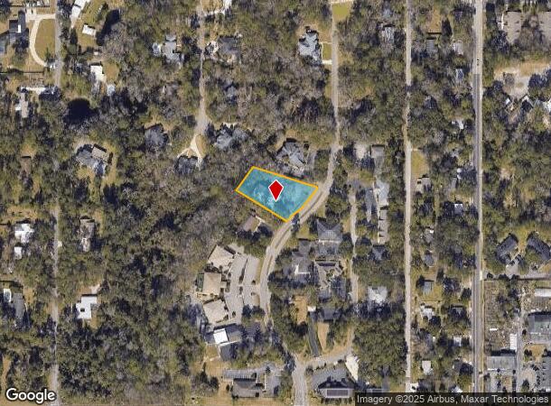
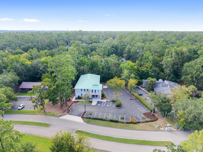
1014 Nw 57Th St
Gainesville, FL
Park Avenue Concourse
06354-010-003
PARK AVE OFFICE CONCOURSE PB M-59 LOT 3 OR 4665/1450
Officebuilding
Alachua
X
Florida
12001C0292D
3
2025
0.75 AC
2025
Northwest Gainesville
001702
Other Market Areas
9,427 SF
DEMOGRAPHICS near 1014 Nw 57Th St
1 Mile
3 Mile
5 Mile
2024 Total Population
5,956
71,616
185,823
2029 Population
6,265
74,986
195,227
Pop Growth 2024-2029
+ 5.19%
+ 4.71%
+ 5.06%
Average Age
38
36
35
2024 Total Households
2,464
29,524
75,830
HH Growth 2024-2029
+ 5.40%
+ 4.78%
+ 5.26%
Median Household Inc
$64,930
$57,366
$54,395
Avg Household Size
2.30
2.20
2.20
2024 Avg HH Vehicles
2.00
2.00
2.00
Median Home Value
$326,872
$286,352
$276,242
Median Year Built
1980
1985
1987
Nearby Places
- Restaurants
- Banks
- Shops
- Fitness
- Groceries
PUBLIC TRANSPORTATION
AIRPORT
Gainesville Regional
DRIVE
WALK
Distance
Gainesville Regional
23 min
10.9 mi
Freight Ports
Jacksonville Port
DRIVE
WALK
Distance
Jacksonville Port
108 min
80.7 mi
Nearby Properties
Address
Land Use
TOTAL SIZE
Lot Size
Zoning
Address
Land Use
TOTAL SIZE
Lot Size
Zoning
790,340 SF
526 AC
ED
Address
Land Use
TOTAL SIZE
Lot Size
Zoning
317,057 SF
128.93 AC
RP
Address
Land Use
TOTAL SIZE
Lot Size
Zoning
1,005,666 SF
11.60 AC
MD
Address
Land Use
TOTAL SIZE
Lot Size
Zoning
348,458 SF
81.44 AC
ED
Address
Land Use
TOTAL SIZE
Lot Size
Zoning
571,635 SF
55.49 AC
RMF6
Address
Land Use
TOTAL SIZE
Lot Size
Zoning
392,241 SF
25 AC
U9
Address
Land Use
TOTAL SIZE
Lot Size
Zoning
141,984 SF
20 AC
HM
Address
Land Use
TOTAL SIZE
Lot Size
Zoning
790,684 SF
57.09 AC
U8
Address
Land Use
TOTAL SIZE
Lot Size
Zoning
392,717 SF
47.62 AC
R-2
Address
Land Use
TOTAL SIZE
Lot Size
Zoning
318,578 SF
21.24 AC
RMF7
Address
Land Use
TOTAL SIZE
Lot Size
Zoning
495,440 SF
14.88 AC
U9
Address
Land Use
TOTAL SIZE
Lot Size
Zoning
153,592 SF
24.98 AC
R-2
Address
Land Use
TOTAL SIZE
Lot Size
Zoning
626,679 SF
41.04 AC
A
Address
Land Use
TOTAL SIZE
Lot Size
Zoning
299,984 SF
10.33 AC
MU2
Address
Land Use
TOTAL SIZE
Lot Size
Zoning
366,764 SF
26.03 AC
RMF6
Address
Land Use
TOTAL SIZE
Lot Size
Zoning
349,789 SF
28.08 AC
PD
Address
Land Use
TOTAL SIZE
Lot Size
Zoning
794,044 SF
80.54 AC
PD
Address
Land Use
TOTAL SIZE
Lot Size
Zoning
385,880 SF
21.51 AC
PD
Address
Land Use
TOTAL SIZE
Lot Size
Zoning
170,185 SF
5.14 AC
R-1AA
Address
Land Use
TOTAL SIZE
Lot Size
Zoning
484,466 SF
7.44 AC
U9
Address
Land Use
TOTAL SIZE
Lot Size
Zoning
206,071 SF
43.34 AC
A
Address
Land Use
TOTAL SIZE
Lot Size
Zoning
230,564 SF
6.34 AC
U9
Address
Land Use
TOTAL SIZE
Lot Size
Zoning
332,878 SF
34.15 AC
PD
Address
Land Use
TOTAL SIZE
Lot Size
Zoning
344,284 SF
31.74 AC
PD
Address
Land Use
TOTAL SIZE
Lot Size
Zoning
228,729 SF
8.10 AC
U9
Address
Land Use
TOTAL SIZE
Lot Size
Zoning
22,710 SF
30 AC
ED
Address
Land Use
TOTAL SIZE
Lot Size
Zoning
326,376 SF
39.94 AC
R-2
Address
Land Use
TOTAL SIZE
Lot Size
Zoning
214,608 SF
21.23 AC
MU2
Address
Land Use
TOTAL SIZE
Lot Size
Zoning
272,730 SF
20.13 AC
PD
Address
Land Use
TOTAL SIZE
Lot Size
Zoning
205,916 SF
9.89 AC
U9
The World's #1 Commercial Real Estate Marketplace
Connect with us
© 2025 CoStar Group
The information above has been obtained from sources believed reliable. While we do not doubt its accuracy we have not verified it and make no guarantee, warranty or representation about it. It is your responsibility to independently confirm its accuracy and completeness. Any projections, opinions, assumptions, or estimates used are for example only and do not represent the current or future performance of the property. The value of this transaction to you depends on tax and other factors which should be evaluated by your tax, financial, and legal advisors. You and your advisors should conduct a careful, independent investigation of the property to determine to your satisfaction the suitability of the property for your needs.