Property Record
1014 Profile Rd, Bethlehem, NH 03574
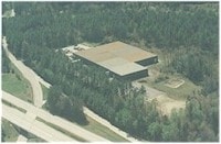

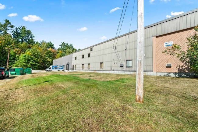
This Property Is For Sale
Current Lease Availabilities
Property Detail
1014 Profile Rd
Commercialbuilding
Grafton
DISTRI
New Hampshire
B and X Area of moderate flood hazard, usually the area between the limits of the 100-year and 500-year floods.
15 AC
2025
Concord/New Hampshire North Area
2025
Other Market Areas
960200
Lebanon-Claremont, NH-VT
84,480 SF
BTHM-000402-000000-000005
NEARBY LISTINGS FOR SALE OR LEASE
DEMOGRAPHICS near 1014 Profile Rd
1 mile
3 mile
5 mile
2025 Total Population
91
2,457
8,873
2030 Population
92
2,512
8,953
Pop Growth 2025-2030
+ 1.10%
+ 2.24%
+ 0.90%
Average Age
48
49
47
2025 Total Households
39
1,128
4,103
HH Growth 2025-2030
0.00%
+ 2.30%
+ 0.95%
Median Household Inc
$85,416
$73,151
$63,545
Avg Household Size
2.20
2.10
2.10
2025 Avg HH Vehicles
2.00
2.00
1.00
Median Home Value
$374,999
$362,962
$323,855
Median Year Built
1969
1970
1964
Nearby Places
Map Layers
Map Styles
 Street
 Aerial
Layers
 Traffic
 Biking
Places
Listings with unknown addresses are not visible on the map
- Restaurants
- Banks
- Shops
- Fitness
- Groceries
Nearby Properties
Address
Land Use
TOTAL SIZE
Lot Size
Zoning
Address
Land Use
TOTAL SIZE
Lot Size
Zoning
105,100 SF
7.82 AC
I
Address
Land Use
TOTAL SIZE
Lot Size
Zoning
20,273 SF
18 AC
DISTRI
Address
Land Use
TOTAL SIZE
Lot Size
Zoning
72,323 SF
23.64 AC
DISTRI
Address
Land Use
TOTAL SIZE
Lot Size
Zoning
16,080 SF
4.23 AC
I
Address
Land Use
TOTAL SIZE
Lot Size
Zoning
77,490 SF
19.10 AC
I
Address
Land Use
TOTAL SIZE
Lot Size
Zoning
4,800 SF
29.34 AC
R-1
Address
Land Use
TOTAL SIZE
Lot Size
Zoning
4.50 AC
R-2
Address
Land Use
TOTAL SIZE
Lot Size
Zoning
29,675 SF
6.86 AC
BUS-A
Address
Land Use
TOTAL SIZE
Lot Size
Zoning
29,496 SF
75 AC
R-1
Address
Land Use
TOTAL SIZE
Lot Size
Zoning
1,354 SF
46 AC
DISTRI
Address
Land Use
TOTAL SIZE
Lot Size
Zoning
40,892 SF
10.02 AC
RES-B
Address
Land Use
TOTAL SIZE
Lot Size
Zoning
27,310 SF
6.13 AC
BUS-A
Address
Land Use
TOTAL SIZE
Lot Size
Zoning
28,686 SF
1.20 AC
BUS-A
Address
Land Use
TOTAL SIZE
Lot Size
Zoning
2,798 SF
3.20 AC
R-1
Address
Land Use
TOTAL SIZE
Lot Size
Zoning
4,449 SF
3.30 AC
GRGENE
Address
Land Use
TOTAL SIZE
Lot Size
Zoning
8,768 SF
19 AC
DISTRI
Address
Land Use
TOTAL SIZE
Lot Size
Zoning
7,557 SF
182.18 AC
DISTRI
Address
Land Use
TOTAL SIZE
Lot Size
Zoning
25,255 SF
2.76 AC
R-1
Address
Land Use
TOTAL SIZE
Lot Size
Zoning
20,588 SF
4.45 AC
C-1
Address
Land Use
TOTAL SIZE
Lot Size
Zoning
6,168 SF
640.21 AC
DISTRI
Address
Land Use
TOTAL SIZE
Lot Size
Zoning
6,876 SF
14.48 AC
GRGENE
Address
Land Use
TOTAL SIZE
Lot Size
Zoning
2,256 SF
2.80 AC
DISTRI
Address
Land Use
TOTAL SIZE
Lot Size
Zoning
83,152 SF
6.14 AC
I
Address
Land Use
TOTAL SIZE
Lot Size
Zoning
1.60 AC
RES-B
Address
Land Use
TOTAL SIZE
Lot Size
Zoning
43.80 AC
DISTRI
Address
Land Use
TOTAL SIZE
Lot Size
Zoning
1,862 SF
2.24 AC
R-1
Address
Land Use
TOTAL SIZE
Lot Size
Zoning
4,308 SF
26.20 AC
DISTRI
Address
Land Use
TOTAL SIZE
Lot Size
Zoning
13,768 SF
4.51 AC
RES-B
Address
Land Use
TOTAL SIZE
Lot Size
Zoning
8,142 SF
0.93 AC
C-1
The World's #1 Commercial Real Estate Marketplace
Connect with us
© 2026 CoStar Group
The information above has been obtained from sources believed reliable. While we do not doubt its accuracy we have not verified it and make no guarantee, warranty or representation about it. It is your responsibility to independently confirm its accuracy and completeness. Any projections, opinions, assumptions, or estimates used are for example only and do not represent the current or future performance of the property. The value of this transaction to you depends on tax and other factors which should be evaluated by your tax, financial, and legal advisors. You and your advisors should conduct a careful, independent investigation of the property to determine to your satisfaction the suitability of the property for your needs.