Property Record
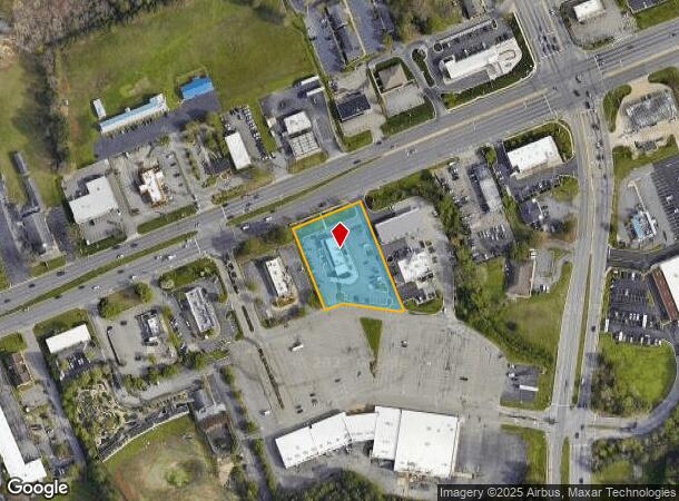
10141 Hull Street Rd, Midlothian, VA 23112
NEARBY LISTINGS FOR SALE OR LEASE
Property Detail
10141 Hull Street Rd
748-68-59-28-600-000
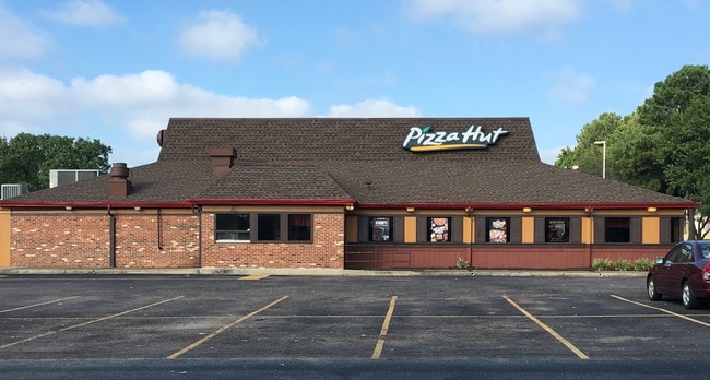
S/S Rt 360 Par C (Pizza Hut)
Restaurantdrivein
S/S RT 360 PAR C (PIZZA HUT)
X
Chesterfield
5101290075E
Virginia
2025
1.29 AC
2025
Midlothian E/Hull St
100934
Richmond VA
2,497 SF
Richmond, VA
DEMOGRAPHICS near 10141 Hull Street Rd
1 Mile
3 Mile
5 Mile
2024 Total Population
4,796
47,158
131,853
2029 Population
5,250
51,488
143,734
Pop Growth 2024-2029
+ 9.47%
+ 9.18%
+ 9.01%
Average Age
41
40
40
2024 Total Households
1,966
17,854
50,036
HH Growth 2024-2029
+ 9.61%
+ 9.37%
+ 9.17%
Median Household Inc
$65,045
$81,536
$82,865
Avg Household Size
2.40
2.60
2.60
2024 Avg HH Vehicles
2.00
2.00
2.00
Median Home Value
$289,980
$272,501
$279,420
Median Year Built
1994
1987
1987
Nearby Places
Map Layers
Map Styles
 Street
 Aerial
- Restaurants
- Banks
- Shops
- Fitness
- Groceries
PUBLIC TRANSPORTATION
AIRPORT
Richmond International
DRIVE
WALK
Distance
Richmond International
33 min
21.7 mi
Freight Ports
Virginia Port Authority - Richmond
DRIVE
WALK
Distance
Virginia Port Authority - Richmond
22 min
11.4 mi
SALE & LEASE HISTORY
LISTING DATE
SALE/LEASE

Aug 16, 2019
For Lease
Nearby Properties
Address
Land Use
TOTAL SIZE
Lot Size
Zoning
Address
Land Use
TOTAL SIZE
Lot Size
Zoning
144,697 SF
97.04 AC
C4 - REGIO
Address
Land Use
TOTAL SIZE
Lot Size
Zoning
137,000 SF
114.67 AC
R9 - SINGL
Address
Land Use
TOTAL SIZE
Lot Size
Zoning
11.22 AC
I1 - LT IN
Address
Land Use
TOTAL SIZE
Lot Size
Zoning
111,744 SF
13.26 AC
C3 - COMMU
Address
Land Use
TOTAL SIZE
Lot Size
Zoning
218,108 SF
20.38 AC
C3 - COMMU
Address
Land Use
TOTAL SIZE
Lot Size
Zoning
62,112 SF
32.90 AC
C3 - COMMU
Address
Land Use
TOTAL SIZE
Lot Size
Zoning
97,740 SF
20.97 AC
R7 - SINGL
Address
Land Use
TOTAL SIZE
Lot Size
Zoning
61,210 SF
12.80 AC
R9 - SINGL
Address
Land Use
TOTAL SIZE
Lot Size
Zoning
53,100 SF
37.74 AC
O2 - CORP
Address
Land Use
TOTAL SIZE
Lot Size
Zoning
57,785 SF
30.27 AC
A - AGRICU
Address
Land Use
TOTAL SIZE
Lot Size
Zoning
102,180 SF
13.97 AC
C4 - REGIO
Address
Land Use
TOTAL SIZE
Lot Size
Zoning
30,000 SF
11.96 AC
C4 - REGIO
Address
Land Use
TOTAL SIZE
Lot Size
Zoning
46,989 SF
2.24 AC
C5 - GEN B
Address
Land Use
TOTAL SIZE
Lot Size
Zoning
34,063 SF
4.18 AC
C5 - GEN B
Address
Land Use
TOTAL SIZE
Lot Size
Zoning
64,000 SF
17.56 AC
A - AGRICU
Address
Land Use
TOTAL SIZE
Lot Size
Zoning
68,933 SF
18.80 AC
R15 - SING
Address
Land Use
TOTAL SIZE
Lot Size
Zoning
68,933 SF
63.44 AC
A - AGRICU
Address
Land Use
TOTAL SIZE
Lot Size
Zoning
80,730 SF
12.71 AC
C4 - REGIO
Address
Land Use
TOTAL SIZE
Lot Size
Zoning
47,351 SF
10.30 AC
C3 - COMMU
Address
Land Use
TOTAL SIZE
Lot Size
Zoning
68,933 SF
19.84 AC
A - AGRICU
Address
Land Use
TOTAL SIZE
Lot Size
Zoning
41,796 SF
13.39 AC
C3 - COMMU
Address
Land Use
TOTAL SIZE
Lot Size
Zoning
110,079 SF
12.38 AC
C3 - COMMU
Address
Land Use
TOTAL SIZE
Lot Size
Zoning
55,000 SF
13.41 AC
C5 - GEN B
Address
Land Use
TOTAL SIZE
Lot Size
Zoning
24,802 SF
12.96 AC
A - AGRICU
Address
Land Use
TOTAL SIZE
Lot Size
Zoning
8,072 SF
7.91 AC
C3 - COMMU
Address
Land Use
TOTAL SIZE
Lot Size
Zoning
48,242 SF
16 AC
C4 - REGIO
Address
Land Use
TOTAL SIZE
Lot Size
Zoning
6,400 SF
12.12 AC
C5 - GEN B
Address
Land Use
TOTAL SIZE
Lot Size
Zoning
35,438 SF
7.81 AC
C3 - COMMU
Address
Land Use
TOTAL SIZE
Lot Size
Zoning
47,102 SF
14.10 AC
I1 - LT IN
Address
Land Use
TOTAL SIZE
Lot Size
Zoning
99,850 SF
7.39 AC
I1 - LT IN
The World's #1 Commercial Real Estate Marketplace
Connect with us
© 2025 CoStar Group
The information above has been obtained from sources believed reliable. While we do not doubt its accuracy we have not verified it and make no guarantee, warranty or representation about it. It is your responsibility to independently confirm its accuracy and completeness. Any projections, opinions, assumptions, or estimates used are for example only and do not represent the current or future performance of the property. The value of this transaction to you depends on tax and other factors which should be evaluated by your tax, financial, and legal advisors. You and your advisors should conduct a careful, independent investigation of the property to determine to your satisfaction the suitability of the property for your needs.