Property Record
10143 Royalton Rd, North Royalton, OH 44133


NEARBY LISTINGS FOR SALE OR LEASE
-
-
View all North Royalton listings for lease on LoopNet.com
Property Detail
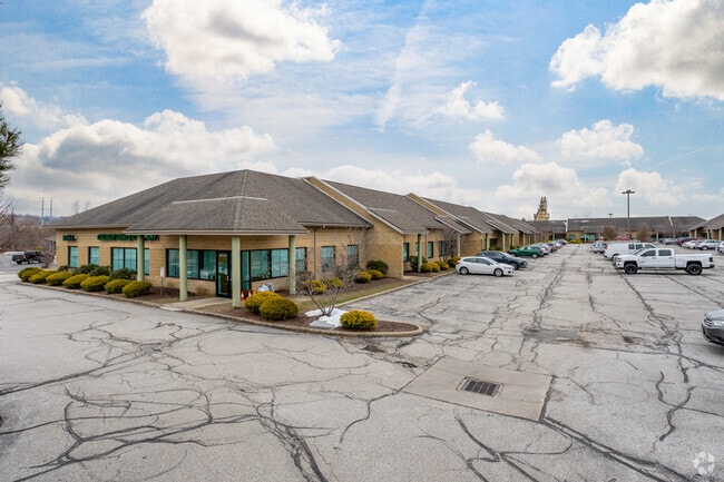
10143 Royalton Rd
Cleveland-Elyria, OH
Royalton Business Park Condominium
483-24-318
8 UNIT D ROYALTON BUSINESS PK CONDO
Warehouse
Cuyahoga
X
Ohio
39035C0284E
d
2024
0.14 AC
2024
Southwest
175201
Cleveland
1,800 SF
DEMOGRAPHICS near 10143 Royalton Rd
1 Mile
3 Mile
5 Mile
2024 Total Population
4,151
38,456
134,649
2029 Population
4,055
37,406
131,328
Pop Growth 2024-2029
(2.31%)
(2.73%)
(2.47%)
Average Age
41
44
44
2024 Total Households
2,152
16,423
56,267
HH Growth 2024-2029
(2.46%)
(2.91%)
(2.69%)
Median Household Inc
$63,440
$79,748
$79,858
Avg Household Size
1.90
2.30
2.30
2024 Avg HH Vehicles
2.00
2.00
2.00
Median Home Value
$204,615
$248,501
$228,713
Median Year Built
1984
1981
1975
Nearby Places
Map Layers
Map Styles
 Street
 Aerial
- Restaurants
- Banks
- Shops
- Fitness
- Groceries
PUBLIC TRANSPORTATION
AIRPORT
Cleveland-Hopkins International
DRIVE
WALK
Distance
Cleveland-Hopkins International
23 min
12.7 mi
Freight Ports
Port of Toledo
DRIVE
WALK
Distance
Port of Toledo
135 min
108.6 mi
SALE & LEASE HISTORY
LISTING DATE
SALE/LEASE

Nov 24, 2020
For Sale
May 23, 2022
For Lease
Feb 01, 2021
For Sale
Feb 01, 2021
For Sale
Aug 26, 2020
For Lease
Apr 29, 2019
For Sale
Nearby Properties
Address
Land Use
TOTAL SIZE
Lot Size
Zoning
Address
Land Use
TOTAL SIZE
Lot Size
Zoning
127,666 SF
2.79 AC
Address
Land Use
TOTAL SIZE
Lot Size
Zoning
485,330 SF
47.02 AC
TCD
Address
Land Use
TOTAL SIZE
Lot Size
Zoning
154,702 SF
23.37 AC
PF
Address
Land Use
TOTAL SIZE
Lot Size
Zoning
168,729 SF
11.56 AC
GB
Address
Land Use
TOTAL SIZE
Lot Size
Zoning
229,190 SF
25.06 AC
GB
Address
Land Use
TOTAL SIZE
Lot Size
Zoning
127,666 SF
9.53 AC
Address
Land Use
TOTAL SIZE
Lot Size
Zoning
149,328 SF
14.78 AC
RM-D
Address
Land Use
TOTAL SIZE
Lot Size
Zoning
143,074 SF
25.34 AC
PDA-2
Address
Land Use
TOTAL SIZE
Lot Size
Zoning
17,682 SF
36.78 AC
MF1
Address
Land Use
TOTAL SIZE
Lot Size
Zoning
39,848 SF
48 AC
RM-D
Address
Land Use
TOTAL SIZE
Lot Size
Zoning
118,375 SF
24.17 AC
RM-D
Address
Land Use
TOTAL SIZE
Lot Size
Zoning
614 SF
19.13 AC
RRZ
Address
Land Use
TOTAL SIZE
Lot Size
Zoning
139,914 SF
17.98 AC
MS
Address
Land Use
TOTAL SIZE
Lot Size
Zoning
149,522 SF
19.09 AC
PF
Address
Land Use
TOTAL SIZE
Lot Size
Zoning
34,005 SF
514.86 AC
PF
Address
Land Use
TOTAL SIZE
Lot Size
Zoning
73,920 SF
22.53 AC
RM-D
Address
Land Use
TOTAL SIZE
Lot Size
Zoning
10,560 SF
22.12 AC
RM-D
Address
Land Use
TOTAL SIZE
Lot Size
Zoning
10,560 SF
19.12 AC
RM-D
Address
Land Use
TOTAL SIZE
Lot Size
Zoning
74,988 SF
19.16 AC
RM-D
Address
Land Use
TOTAL SIZE
Lot Size
Zoning
242.53 AC
PF
Address
Land Use
TOTAL SIZE
Lot Size
Zoning
147,287 SF
15.58 AC
MS
Address
Land Use
TOTAL SIZE
Lot Size
Zoning
128,979 SF
3.87 AC
R1-75
Address
Land Use
TOTAL SIZE
Lot Size
Zoning
178,194 SF
18.93 AC
RM-D
Address
Land Use
TOTAL SIZE
Lot Size
Zoning
195.95 AC
PF
Address
Land Use
TOTAL SIZE
Lot Size
Zoning
191.03 AC
PF
Address
Land Use
TOTAL SIZE
Lot Size
Zoning
204,594 SF
22.97 AC
R1-A
Address
Land Use
TOTAL SIZE
Lot Size
Zoning
83,969 SF
10.94 AC
PF
Address
Land Use
TOTAL SIZE
Lot Size
Zoning
10.64 AC
PF
Address
Land Use
TOTAL SIZE
Lot Size
Zoning
66,454 SF
4.81 AC
PUD
Address
Land Use
TOTAL SIZE
Lot Size
Zoning
6,084 SF
29.55 AC
The World's #1 Commercial Real Estate Marketplace
Connect with us
© 2026 CoStar Group
The information above has been obtained from sources believed reliable. While we do not doubt its accuracy we have not verified it and make no guarantee, warranty or representation about it. It is your responsibility to independently confirm its accuracy and completeness. Any projections, opinions, assumptions, or estimates used are for example only and do not represent the current or future performance of the property. The value of this transaction to you depends on tax and other factors which should be evaluated by your tax, financial, and legal advisors. You and your advisors should conduct a careful, independent investigation of the property to determine to your satisfaction the suitability of the property for your needs.