Property Record
10145 Alondra Blvd, Bellflower, CA 90706
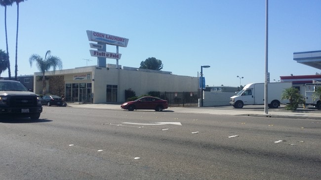

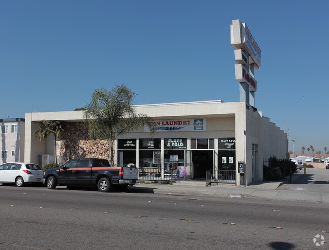

This Property Is For Sale
NEARBY LISTINGS FOR SALE OR LEASE
Property Detail
10145 Alondra Blvd
Los Angeles-Long Beach-Glendale, CA
Somerset Acres
6274-037-045
SOMERSET ACRES LOT COM E 82 FT FROM NW COR OF LOT 11 TH S 206.22 FT TH W 1.5 FT TH S 109 FT TH E ON N LINE OF ALONDRA BLVD 87.5 FT TH N TO N LINE OF LOT 10 TH W 86 FT TO BEG PART OF LOTS 10 AND LOT 11
Commercialnec
Los Angeles
X
California
06037C1840F
11
2024
0.63 AC
2025
Mid-Cities
554106
Los Angeles
5,174 SF
DEMOGRAPHICS near 10145 Alondra Blvd
1 Mile
3 Mile
5 Mile
2024 Total Population
37,792
274,373
670,811
2029 Population
36,816
265,076
646,513
Pop Growth 2024-2029
(2.58%)
(3.39%)
(3.62%)
Average Age
37
39
39
2024 Total Households
11,709
80,058
196,720
HH Growth 2024-2029
(2.78%)
(3.63%)
(3.87%)
Median Household Inc
$66,845
$79,526
$81,364
Avg Household Size
3.10
3.30
3.30
2024 Avg HH Vehicles
2.00
2.00
2.00
Median Home Value
$682,403
$668,717
$686,456
Median Year Built
1962
1960
1959
Nearby Places
Map Layers
Map Styles
 Street
 Aerial
- Restaurants
- Banks
- Shops
- Fitness
- Groceries
PUBLIC TRANSPORTATION
COMMUTER RAIL
Norwalk/Santa Fe Springs (91 Line - Southern California Regional Rail Authority (Metrolink), Orange County Line - Southern California Regional Rail Authority (Metrolink))
DRIVE
WALK
Distance
Norwalk/Santa Fe Springs (91 Line - Southern California Regional Rail Authority (Metrolink), Orange County Line - Southern California Regional Rail Authority (Metrolink))
10 min
5.0 mi
Buena Park (91 Line - Southern California Regional Rail Authority (Metrolink), Orange County Line - Southern California Regional Rail Authority (Metrolink))
DRIVE
WALK
Distance
Buena Park (91 Line - Southern California Regional Rail Authority (Metrolink), Orange County Line - Southern California Regional Rail Authority (Metrolink))
15 min
8.1 mi
AIRPORT
Long Beach (Daugherty Field)
DRIVE
WALK
Distance
Long Beach (Daugherty Field)
15 min
8.4 mi
Los Angeles International
DRIVE
WALK
Distance
Los Angeles International
27 min
20.1 mi
John Wayne/Orange County
DRIVE
WALK
Distance
John Wayne/Orange County
31 min
24.1 mi
Nearby Properties
Address
Land Use
TOTAL SIZE
Lot Size
Zoning
Address
Land Use
TOTAL SIZE
Lot Size
Zoning
1,339,758 SF
28.53 AC
DOM2-P*
Address
Land Use
TOTAL SIZE
Lot Size
Zoning
324,400 SF
55.03 AC
CECR
Address
Land Use
TOTAL SIZE
Lot Size
Zoning
556,348 SF
26.38 AC
PAM2
Address
Land Use
TOTAL SIZE
Lot Size
Zoning
383,495 SF
11.60 AC
DOR3PUD*
Address
Land Use
TOTAL SIZE
Lot Size
Zoning
730,731 SF
14.89 AC
BFCG*
Address
Land Use
TOTAL SIZE
Lot Size
Zoning
353,001 SF
4.81 AC
CEM
Address
Land Use
TOTAL SIZE
Lot Size
Zoning
395,436 SF
17.22 AC
LBMG
Address
Land Use
TOTAL SIZE
Lot Size
Zoning
371,464 SF
9.28 AC
DOM2-P*
Address
Land Use
TOTAL SIZE
Lot Size
Zoning
247,536 SF
5.79 AC
CECR
Address
Land Use
TOTAL SIZE
Lot Size
Zoning
106,028 SF
6.42 AC
DOM2-P*
Address
Land Use
TOTAL SIZE
Lot Size
Zoning
140,624 SF
4.35 AC
ATMRV1200*
Address
Land Use
TOTAL SIZE
Lot Size
Zoning
80,114 SF
1.27 AC
LKC4*
Address
Land Use
TOTAL SIZE
Lot Size
Zoning
99,674 SF
6.53 AC
DOM2-P*
Address
Land Use
TOTAL SIZE
Lot Size
Zoning
299,406 SF
1.72 AC
LKC4*
Address
Land Use
TOTAL SIZE
Lot Size
Zoning
1,004,620 SF
19.73 AC
CECR
Address
Land Use
TOTAL SIZE
Lot Size
Zoning
132,019 SF
5.22 AC
LKMFR*
Address
Land Use
TOTAL SIZE
Lot Size
Zoning
80,339 SF
5.88 AC
ATCPD*
Address
Land Use
TOTAL SIZE
Lot Size
Zoning
266,036 SF
6.13 AC
ATCS
Address
Land Use
TOTAL SIZE
Lot Size
Zoning
398,222 SF
9.52 AC
NOC3-P*
Address
Land Use
TOTAL SIZE
Lot Size
Zoning
624,452 SF
Address
Land Use
TOTAL SIZE
Lot Size
Zoning
96,849 SF
7.56 AC
LKC3YY
Address
Land Use
TOTAL SIZE
Lot Size
Zoning
155,384 SF
11.59 AC
DOM2-P*
Address
Land Use
TOTAL SIZE
Lot Size
Zoning
183,128 SF
10.77 AC
PAM2*
Address
Land Use
TOTAL SIZE
Lot Size
Zoning
193,451 SF
6.31 AC
DOM2*
Address
Land Use
TOTAL SIZE
Lot Size
Zoning
89,760 SF
3.67 AC
DOM2*
Address
Land Use
TOTAL SIZE
Lot Size
Zoning
111,746 SF
4.38 AC
DOM2-P*
Address
Land Use
TOTAL SIZE
Lot Size
Zoning
439,058 SF
8.57 AC
DOM2*
Address
Land Use
TOTAL SIZE
Lot Size
Zoning
107,964 SF
2.12 AC
NOC3
Address
Land Use
TOTAL SIZE
Lot Size
Zoning
193,300 SF
4.22 AC
CECR
Address
Land Use
TOTAL SIZE
Lot Size
Zoning
131,914 SF
10.15 AC
CECR
The World's #1 Commercial Real Estate Marketplace
Connect with us
© 2025 CoStar Group
The information above has been obtained from sources believed reliable. While we do not doubt its accuracy we have not verified it and make no guarantee, warranty or representation about it. It is your responsibility to independently confirm its accuracy and completeness. Any projections, opinions, assumptions, or estimates used are for example only and do not represent the current or future performance of the property. The value of this transaction to you depends on tax and other factors which should be evaluated by your tax, financial, and legal advisors. You and your advisors should conduct a careful, independent investigation of the property to determine to your satisfaction the suitability of the property for your needs.