Property Record
10145 E Old Vail Rd, Tucson, AZ 85747
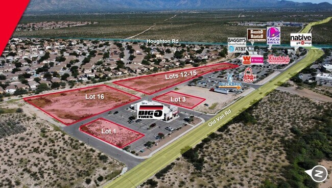
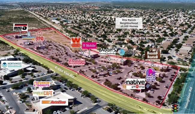
Property Detail
10145 E Old Vail Rd
Tucson, AZ
OLD VAIL PLAZA SQ20112770309 LOT 3
141-18-5960
PIMA
Commercialacreage
Arizona
B and X Area of moderate flood hazard, usually the area between the limits of the 100-year and 500-year floods.
3
2025
0.27 AC
2026
Southeast Tucson
004074
Tucson
NEARBY LISTINGS FOR SALE OR LEASE
DEMOGRAPHICS near 10145 E Old Vail Rd
1 mile
3 mile
5 mile
2025 Total Population
4,947
18,124
46,611
2030 Population
4,988
18,648
48,589
Pop Growth 2025-2030
+ 0.83%
+ 2.89%
+ 4.24%
Average Age
36
36
38
2025 Total Households
1,714
6,215
16,385
HH Growth 2025-2030
+ 0.88%
+ 2.96%
+ 4.25%
Median Household Inc
$131,006
$110,556
$112,621
Avg Household Size
2.80
2.90
2.80
2025 Avg HH Vehicles
2.00
2.00
2.00
Median Home Value
$329,891
$342,429
$371,808
Median Year Built
1996
1998
2004
Nearby Places
Map Layers
Map Styles
 Street
 Aerial
Transit
 Traffic
 Biking
Places
Listings with unknown addresses are not visible on the map
- Restaurants
- Banks
- Shops
- Fitness
- Groceries
PUBLIC TRANSPORTATION
AIRPORT
Tucson International
Drive
Walk
Distance
Tucson International
22 min
13.1 mi
SALE & LEASE HISTORY
LISTING DATE
SALE/LEASE

Sep 24, 2016
For Sale
Nov 11, 2022
For Sale
Jul 24, 2020
For Sale
Apr 06, 2018
For Sale
Nearby Properties
Address
Land Use
TOTAL SIZE
Lot Size
Zoning
Address
Land Use
TOTAL SIZE
Lot Size
Zoning
489,276 SF
85 AC
I2
Address
Land Use
TOTAL SIZE
Lot Size
Zoning
1,698,495 SF
751.94 AC
Address
Land Use
TOTAL SIZE
Lot Size
Zoning
39,726 SF
15.74 AC
Address
Land Use
TOTAL SIZE
Lot Size
Zoning
53,820 SF
6.88 AC
I2
Address
Land Use
TOTAL SIZE
Lot Size
Zoning
340,031 SF
17.14 AC
Address
Land Use
TOTAL SIZE
Lot Size
Zoning
44,323 SF
17.35 AC
Address
Land Use
TOTAL SIZE
Lot Size
Zoning
4,931 SF
18.33 AC
TH
Address
Land Use
TOTAL SIZE
Lot Size
Zoning
971,480 SF
97.71 AC
I1
Address
Land Use
TOTAL SIZE
Lot Size
Zoning
133,992 SF
43.35 AC
RX1
Address
Land Use
TOTAL SIZE
Lot Size
Zoning
109,650 SF
10.29 AC
Address
Land Use
TOTAL SIZE
Lot Size
Zoning
10,455 SF
5 AC
O3
Address
Land Use
TOTAL SIZE
Lot Size
Zoning
78,166 SF
23.16 AC
RX1
Address
Land Use
TOTAL SIZE
Lot Size
Zoning
14,427 SF
13.43 AC
I2
Address
Land Use
TOTAL SIZE
Lot Size
Zoning
73,280 SF
10 AC
RX1
Address
Land Use
TOTAL SIZE
Lot Size
Zoning
45.88 AC
Address
Land Use
TOTAL SIZE
Lot Size
Zoning
62,451 SF
10 AC
RX1
Address
Land Use
TOTAL SIZE
Lot Size
Zoning
103,074 SF
13.84 AC
Address
Land Use
TOTAL SIZE
Lot Size
Zoning
62,087 SF
3.43 AC
Address
Land Use
TOTAL SIZE
Lot Size
Zoning
91,519 SF
11.03 AC
Address
Land Use
TOTAL SIZE
Lot Size
Zoning
56,316 SF
5.15 AC
Address
Land Use
TOTAL SIZE
Lot Size
Zoning
132,299 SF
14.53 AC
GR1
Address
Land Use
TOTAL SIZE
Lot Size
Zoning
34.27 AC
Address
Land Use
TOTAL SIZE
Lot Size
Zoning
70,960 SF
7.67 AC
C2
Address
Land Use
TOTAL SIZE
Lot Size
Zoning
115,646 SF
11.99 AC
I1
Address
Land Use
TOTAL SIZE
Lot Size
Zoning
21,704 SF
5 AC
I2
Address
Land Use
TOTAL SIZE
Lot Size
Zoning
36,748 SF
10 AC
RX1
Address
Land Use
TOTAL SIZE
Lot Size
Zoning
64,130 SF
5.63 AC
C1
Address
Land Use
TOTAL SIZE
Lot Size
Zoning
5,447 SF
8.55 AC
I2
Address
Land Use
TOTAL SIZE
Lot Size
Zoning
169,808 SF
13.32 AC
I2
Address
Land Use
TOTAL SIZE
Lot Size
Zoning
28,226 SF
5 AC
RX1
The World's #1 Commercial Real Estate Marketplace
Connect with us
© 2026 CoStar Group
The information above has been obtained from sources believed reliable. While we do not doubt its accuracy we have not verified it and make no guarantee, warranty or representation about it. It is your responsibility to independently confirm its accuracy and completeness. Any projections, opinions, assumptions, or estimates used are for example only and do not represent the current or future performance of the property. The value of this transaction to you depends on tax and other factors which should be evaluated by your tax, financial, and legal advisors. You and your advisors should conduct a careful, independent investigation of the property to determine to your satisfaction the suitability of the property for your needs.