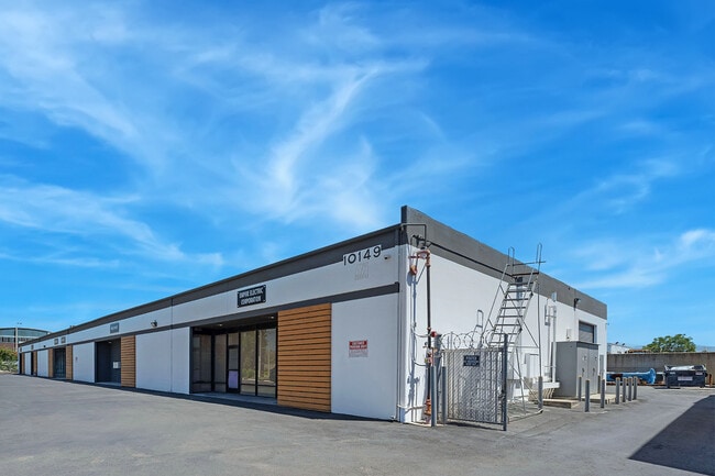
Property Record
10149 Channel Rd, Lakeside, CA 92040

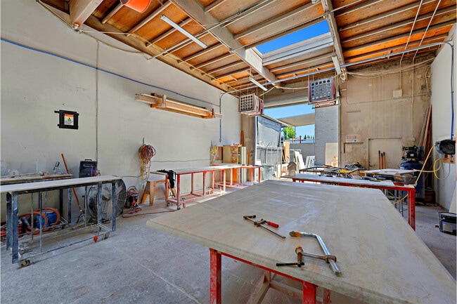
Current Lease Availabilities
Property Detail
10149 Channel Rd
394-011-13
PAR 1 TR PM06232
Lightindustrial
San Diego
S88
California
B and X Area of moderate flood hazard, usually the area between the limits of the 100-year and 500-year floods.
59
2024
1 AC
2025
Santee
016901
San Diego
14,472 SF
San Diego-Chula Vista-Carlsbad, CA
NEARBY LISTINGS FOR SALE OR LEASE
DEMOGRAPHICS near 10149 Channel Rd
1 mile
3 mile
5 mile
2025 Total Population
15,342
76,845
181,060
2030 Population
15,511
76,891
180,698
Pop Growth 2025-2030
+ 1.10%
+ 0.06%
(0.20%)
Average Age
38
40
39
2025 Total Households
5,558
26,475
61,702
HH Growth 2025-2030
+ 0.88%
(0.08%)
(0.36%)
Median Household Inc
$84,118
$106,936
$90,255
Avg Household Size
2.70
2.80
2.80
2025 Avg HH Vehicles
2.00
2.00
2.00
Median Home Value
$643,481
$684,225
$691,347
Median Year Built
1978
1978
1977
Nearby Places
Map Layers
Map Styles
 Street
 Aerial
Layers
 Traffic
 Biking
Places
Listings with unknown addresses are not visible on the map
- Restaurants
- Banks
- Shops
- Fitness
- Groceries
PUBLIC TRANSPORTATION
AIRPORT
San Diego International
Drive
Walk
Distance
San Diego International
31 min
22.6 mi
Freight Ports
Port of San Diego
Drive
Walk
Distance
Port of San Diego
29 min
21.5 mi
Nearby Properties
Address
Land Use
TOTAL SIZE
Lot Size
Zoning
Address
Land Use
TOTAL SIZE
Lot Size
Zoning
5.77 AC
RU
Address
Land Use
TOTAL SIZE
Lot Size
Zoning
10.23 AC
R22
Address
Land Use
TOTAL SIZE
Lot Size
Zoning
38.80 AC
RMH8
Address
Land Use
TOTAL SIZE
Lot Size
Zoning
5.45 AC
R14
Address
Land Use
TOTAL SIZE
Lot Size
Zoning
3.80 AC
NC/R14
Address
Land Use
TOTAL SIZE
Lot Size
Zoning
4.93 AC
C36
Address
Land Use
TOTAL SIZE
Lot Size
Zoning
4.75 AC
C-6
Address
Land Use
TOTAL SIZE
Lot Size
Zoning
3.33 AC
R22
Address
Land Use
TOTAL SIZE
Lot Size
Zoning
79,662 SF
8.21 AC
S88
Address
Land Use
TOTAL SIZE
Lot Size
Zoning
67,722 SF
3.57 AC
RM-2500
Address
Land Use
TOTAL SIZE
Lot Size
Zoning
8.72 AC
R14
Address
Land Use
TOTAL SIZE
Lot Size
Zoning
4.61 AC
R7
Address
Land Use
TOTAL SIZE
Lot Size
Zoning
56,525 SF
6.29 AC
S88
Address
Land Use
TOTAL SIZE
Lot Size
Zoning
87,704 SF
3.74 AC
RU
Address
Land Use
TOTAL SIZE
Lot Size
Zoning
93,339 SF
5.16 AC
IL/GC
Address
Land Use
TOTAL SIZE
Lot Size
Zoning
9.93 AC
S88
Address
Land Use
TOTAL SIZE
Lot Size
Zoning
81,578 SF
4.95 AC
R14
Address
Land Use
TOTAL SIZE
Lot Size
Zoning
35.63 AC
S88
Address
Land Use
TOTAL SIZE
Lot Size
Zoning
90,405 SF
5.44 AC
IL
Address
Land Use
TOTAL SIZE
Lot Size
Zoning
57,840 SF
5.59 AC
R7
Address
Land Use
TOTAL SIZE
Lot Size
Zoning
7.66 AC
S88
Address
Land Use
TOTAL SIZE
Lot Size
Zoning
90,936 SF
3.70 AC
C34
Address
Land Use
TOTAL SIZE
Lot Size
Zoning
53,250 SF
5.28 AC
NC
Address
Land Use
TOTAL SIZE
Lot Size
Zoning
11,285 SF
2.81 AC
C37
Address
Land Use
TOTAL SIZE
Lot Size
Zoning
3,368 SF
33.63 AC
RMH6
Address
Land Use
TOTAL SIZE
Lot Size
Zoning
43,500 SF
3.79 AC
C34
Address
Land Use
TOTAL SIZE
Lot Size
Zoning
7.01 AC
RU
Address
Land Use
TOTAL SIZE
Lot Size
Zoning
30,086 SF
2.80 AC
GC
Address
Land Use
TOTAL SIZE
Lot Size
Zoning
53,357 SF
2.04 AC
C34
Address
Land Use
TOTAL SIZE
Lot Size
Zoning
78,759 SF
7.28 AC
IG
The World's #1 Commercial Real Estate Marketplace
Connect with us
© 2026 CoStar Group
The information above has been obtained from sources believed reliable. While we do not doubt its accuracy we have not verified it and make no guarantee, warranty or representation about it. It is your responsibility to independently confirm its accuracy and completeness. Any projections, opinions, assumptions, or estimates used are for example only and do not represent the current or future performance of the property. The value of this transaction to you depends on tax and other factors which should be evaluated by your tax, financial, and legal advisors. You and your advisors should conduct a careful, independent investigation of the property to determine to your satisfaction the suitability of the property for your needs.