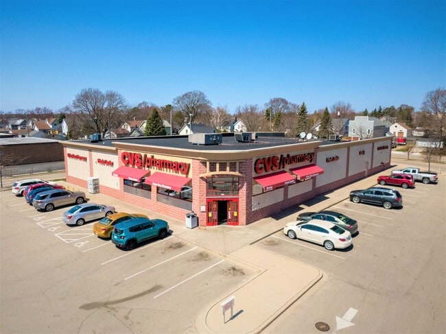
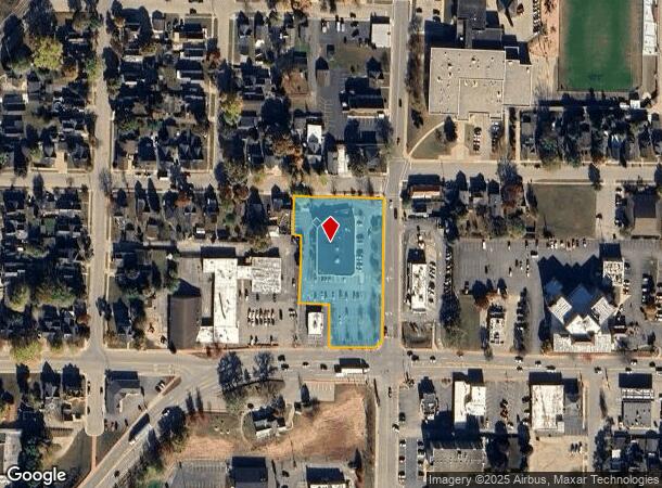
Property Record
1015 13Th St, Menominee, MI 49858
NEARBY LISTINGS FOR SALE OR LEASE
Property Detail
1015 13Th St
051-011-130-10
THAT PART OF THE SE 1/4 OF THE NE 1/4 OF SECTION 3, TOWN 31 NORTH RANGE 27 WEST COM AT THE SOUTHEAST CORNER OF THE NE 1/4 OF
Commercialnec
Menominee
X
Michigan
26109C0801E
1.71 AC
2025
Upper Peninsula
2025
Other Market Areas
960600
Marinette, WI-MI
13,225 SF
DEMOGRAPHICS near 1015 13Th St
1 Mile
3 Mile
5 Mile
2024 Total Population
7,452
23,676
24,835
2029 Population
7,572
24,034
25,187
Pop Growth 2024-2029
+ 1.61%
+ 1.51%
+ 1.42%
Average Age
43
43
43
2024 Total Households
3,563
10,923
11,427
HH Growth 2024-2029
+ 1.71%
+ 1.55%
+ 1.44%
Median Household Inc
$50,116
$52,319
$53,205
Avg Household Size
2.00
2.10
2.10
2024 Avg HH Vehicles
1.00
2.00
2.00
Median Home Value
$82,485
$96,143
$100,530
Median Year Built
1957
1968
1970
Nearby Places
Map Layers
Map Styles
 Street
 Aerial
- Restaurants
- Banks
- Shops
- Fitness
- Groceries
SALE & LEASE HISTORY
LISTING DATE
SALE/LEASE

Apr 30, 2021
For Sale
Nearby Properties
Address
Land Use
TOTAL SIZE
Lot Size
Zoning
Address
Land Use
TOTAL SIZE
Lot Size
Zoning
19.68 AC
Address
Land Use
TOTAL SIZE
Lot Size
Zoning
8.50 AC
Address
Land Use
TOTAL SIZE
Lot Size
Zoning
28.13 AC
Address
Land Use
TOTAL SIZE
Lot Size
Zoning
27.53 AC
Address
Land Use
TOTAL SIZE
Lot Size
Zoning
14.64 AC
Address
Land Use
TOTAL SIZE
Lot Size
Zoning
88.80 AC
Address
Land Use
TOTAL SIZE
Lot Size
Zoning
2.32 AC
Address
Land Use
TOTAL SIZE
Lot Size
Zoning
44.93 AC
Address
Land Use
TOTAL SIZE
Lot Size
Zoning
38.43 AC
Address
Land Use
TOTAL SIZE
Lot Size
Zoning
5.44 AC
Address
Land Use
TOTAL SIZE
Lot Size
Zoning
37.80 AC
Address
Land Use
TOTAL SIZE
Lot Size
Zoning
6.55 AC
Address
Land Use
TOTAL SIZE
Lot Size
Zoning
1.91 AC
Address
Land Use
TOTAL SIZE
Lot Size
Zoning
Address
Land Use
TOTAL SIZE
Lot Size
Zoning
Address
Land Use
TOTAL SIZE
Lot Size
Zoning
1.77 AC
Address
Land Use
TOTAL SIZE
Lot Size
Zoning
15.41 AC
Address
Land Use
TOTAL SIZE
Lot Size
Zoning
9.65 AC
Address
Land Use
TOTAL SIZE
Lot Size
Zoning
106,262 SF
18.66 AC
R1
Address
Land Use
TOTAL SIZE
Lot Size
Zoning
Address
Land Use
TOTAL SIZE
Lot Size
Zoning
265,051 SF
13.99 AC
R1
Address
Land Use
TOTAL SIZE
Lot Size
Zoning
6.55 AC
Address
Land Use
TOTAL SIZE
Lot Size
Zoning
2.36 AC
Address
Land Use
TOTAL SIZE
Lot Size
Zoning
Address
Land Use
TOTAL SIZE
Lot Size
Zoning
Address
Land Use
TOTAL SIZE
Lot Size
Zoning
447,920 SF
48.04 AC
M1
Address
Land Use
TOTAL SIZE
Lot Size
Zoning
307,172 SF
29.15 AC
R1
Address
Land Use
TOTAL SIZE
Lot Size
Zoning
14.57 AC
Address
Land Use
TOTAL SIZE
Lot Size
Zoning
79,836 SF
3.51 AC
R1
Address
Land Use
TOTAL SIZE
Lot Size
Zoning
The World's #1 Commercial Real Estate Marketplace
Connect with us
© 2025 CoStar Group
The information above has been obtained from sources believed reliable. While we do not doubt its accuracy we have not verified it and make no guarantee, warranty or representation about it. It is your responsibility to independently confirm its accuracy and completeness. Any projections, opinions, assumptions, or estimates used are for example only and do not represent the current or future performance of the property. The value of this transaction to you depends on tax and other factors which should be evaluated by your tax, financial, and legal advisors. You and your advisors should conduct a careful, independent investigation of the property to determine to your satisfaction the suitability of the property for your needs.