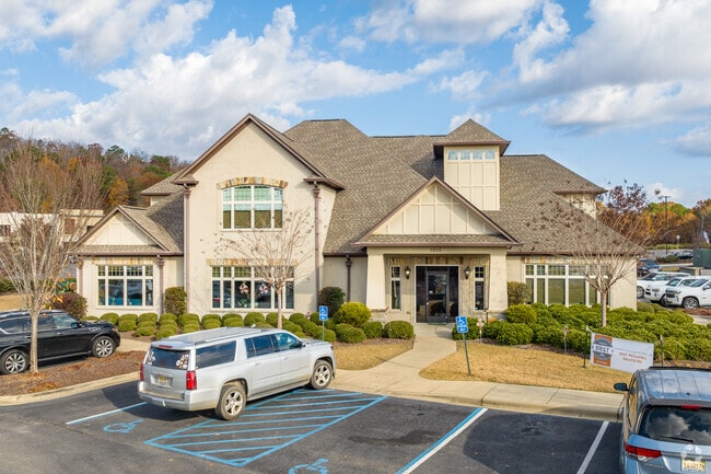
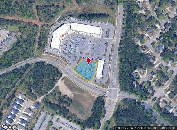
Property Record
1015 Brocks Gap Pky, Hoover, AL 35244
NEARBY LISTINGS FOR SALE OR LEASE
Property Detail
1015 Brocks Gap Pky
Birmingham-Hoover, AL
Hoover Family Festival Res Lt
39-00-33-1-000-001.016
LOT 3 HOOVER FAMILY FESTIVAL RES LT 1 PB 46 PG 84 (250 X 241.2 IRR)
Medicalbuilding
Jefferson
X
Alabama
01073C0701H
3,1
2023
0.97 AC
2024
Hoover
014410
Birmingham
9,525 SF
DEMOGRAPHICS near 1015 Brocks Gap Pky
1 Mile
3 Mile
5 Mile
2024 Total Population
2,695
36,406
98,805
2029 Population
2,646
36,694
100,702
Pop Growth 2024-2029
(1.82%)
+ 0.79%
+ 1.92%
Average Age
43
41
39
2024 Total Households
916
13,932
38,665
HH Growth 2024-2029
(1.86%)
+ 0.85%
+ 1.73%
Median Household Inc
$162,278
$103,621
$89,347
Avg Household Size
2.80
2.60
2.50
2024 Avg HH Vehicles
2.00
2.00
2.00
Median Home Value
$427,869
$346,182
$294,212
Median Year Built
2001
1995
1992
Nearby Places
Map Layers
Map Styles
 Street
 Aerial
- Restaurants
- Banks
- Shops
- Fitness
- Groceries
PUBLIC TRANSPORTATION
AIRPORT
Birmingham-Shuttlesworth International
DRIVE
WALK
Distance
Birmingham-Shuttlesworth International
31 min
20.4 mi
SALE & LEASE HISTORY
LISTING DATE
SALE/LEASE

Sep 05, 2018
For Lease
Nearby Properties
Address
Land Use
TOTAL SIZE
Lot Size
Zoning
Address
Land Use
TOTAL SIZE
Lot Size
Zoning
333,513 SF
40.80 AC
C2
Address
Land Use
TOTAL SIZE
Lot Size
Zoning
582,638 SF
43.76 AC
PUDP
Address
Land Use
TOTAL SIZE
Lot Size
Zoning
69,151 SF
4.90 AC
PC
Address
Land Use
TOTAL SIZE
Lot Size
Zoning
186,953 SF
20 AC
PR2
Address
Land Use
TOTAL SIZE
Lot Size
Zoning
237,921 SF
6.35 AC
PUDP
Address
Land Use
TOTAL SIZE
Lot Size
Zoning
284,436 SF
40.98 AC
PUDP
Address
Land Use
TOTAL SIZE
Lot Size
Zoning
241,232 SF
15.01 AC
PR2
Address
Land Use
TOTAL SIZE
Lot Size
Zoning
165,474 SF
90 AC
PR2
Address
Land Use
TOTAL SIZE
Lot Size
Zoning
160,443 SF
23 AC
C-2
Address
Land Use
TOTAL SIZE
Lot Size
Zoning
238,304 SF
18.90 AC
PR-2
Address
Land Use
TOTAL SIZE
Lot Size
Zoning
200,679 SF
20 AC
PR2
Address
Land Use
TOTAL SIZE
Lot Size
Zoning
231,385 SF
50.40 AC
R6
Address
Land Use
TOTAL SIZE
Lot Size
Zoning
224,746 SF
46 AC
C2
Address
Land Use
TOTAL SIZE
Lot Size
Zoning
172,648 SF
39.45 AC
Address
Land Use
TOTAL SIZE
Lot Size
Zoning
22,726 SF
15.77 AC
Address
Land Use
TOTAL SIZE
Lot Size
Zoning
230,053 SF
23 AC
Address
Land Use
TOTAL SIZE
Lot Size
Zoning
121,049 SF
9.10 AC
PR2
Address
Land Use
TOTAL SIZE
Lot Size
Zoning
185,856 SF
6.70 AC
PC
Address
Land Use
TOTAL SIZE
Lot Size
Zoning
152,735 SF
9.80 AC
R-4
Address
Land Use
TOTAL SIZE
Lot Size
Zoning
105,299 SF
25.50 AC
T3
Address
Land Use
TOTAL SIZE
Lot Size
Zoning
141,296 SF
14.51 AC
C2
Address
Land Use
TOTAL SIZE
Lot Size
Zoning
83,700 SF
60 AC
PC
Address
Land Use
TOTAL SIZE
Lot Size
Zoning
94,329 SF
15.60 AC
C1
Address
Land Use
TOTAL SIZE
Lot Size
Zoning
35,503 SF
2.92 AC
C2
Address
Land Use
TOTAL SIZE
Lot Size
Zoning
2,826 SF
74.16 AC
Address
Land Use
TOTAL SIZE
Lot Size
Zoning
41,374 SF
3.70 AC
PUD-
Address
Land Use
TOTAL SIZE
Lot Size
Zoning
7,000 SF
19 AC
Address
Land Use
TOTAL SIZE
Lot Size
Zoning
49,324 SF
12.40 AC
PC
Address
Land Use
TOTAL SIZE
Lot Size
Zoning
29,302 SF
1.20 AC
A1
Address
Land Use
TOTAL SIZE
Lot Size
Zoning
108,525 SF
10.90 AC
PC
The World's #1 Commercial Real Estate Marketplace
Connect with us
© 2025 CoStar Group
The information above has been obtained from sources believed reliable. While we do not doubt its accuracy we have not verified it and make no guarantee, warranty or representation about it. It is your responsibility to independently confirm its accuracy and completeness. Any projections, opinions, assumptions, or estimates used are for example only and do not represent the current or future performance of the property. The value of this transaction to you depends on tax and other factors which should be evaluated by your tax, financial, and legal advisors. You and your advisors should conduct a careful, independent investigation of the property to determine to your satisfaction the suitability of the property for your needs.