Property Record
1015 Highway 28 Byp, , SC

Save to a Folder
{{folder.Name}}
{{folder.ListingIds.length}} Properties
{{folder.ListingIds.length}} Property
Create a New Folder
Property Detail
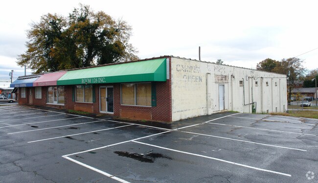
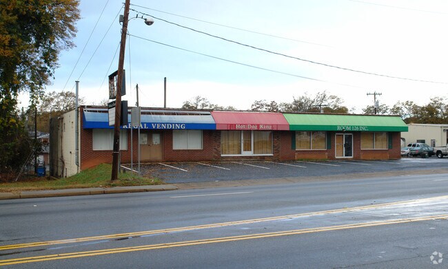
1015 Highway 28 Byp
Greenville-Anderson-Greer, SC
CP 076/00396 F 00110D 00177 PP 060/00004 LOT 10 28 BY PASS
124-01-04-002
ANDERSON
Bartavern
South Carolina
B and X Area of moderate flood hazard, usually the area between the limits of the 100-year and 500-year floods.
10,28
2025
0.45 AC
2025
Anderson Cy S of I-85
012002
Greenville/Spartanburg
7,032 SF
NEARBY LISTINGS FOR SALE OR LEASE
DEMOGRAPHICS near 1015 Highway 28 Byp
1 mile
3 mile
5 mile
2025 Total Population
3,553
36,317
75,130
2030 Population
3,742
38,510
79,283
Pop Growth 2025-2030
+ 5.32%
+ 6.04%
+ 5.53%
Average Age
40
39
40
2025 Total Households
1,551
14,763
30,399
HH Growth 2025-2030
+ 5.48%
+ 6.20%
+ 5.66%
Median Household Inc
$29,918
$43,572
$53,176
Avg Household Size
2.30
2.30
2.30
2025 Avg HH Vehicles
1.00
2.00
2.00
Median Home Value
$146,190
$178,397
$215,116
Median Year Built
1982
1975
1982
Nearby Places
Map Layers
Map Styles
 Street
 Aerial
Layers
 Traffic
 Biking
Places
Listings with unknown addresses are not visible on the map
- Restaurants
- Banks
- Shops
- Fitness
- Groceries
Nearby Properties
Address
Land Use
TOTAL SIZE
Lot Size
Zoning
Address
Land Use
TOTAL SIZE
Lot Size
Zoning
17.16 AC
Address
Land Use
TOTAL SIZE
Lot Size
Zoning
27,441 SF
5.49 AC
Address
Land Use
TOTAL SIZE
Lot Size
Zoning
183,500 SF
19.79 AC
Address
Land Use
TOTAL SIZE
Lot Size
Zoning
121,232 SF
19.72 AC
Address
Land Use
TOTAL SIZE
Lot Size
Zoning
2,027 SF
12.16 AC
Address
Land Use
TOTAL SIZE
Lot Size
Zoning
27,372 SF
2.49 AC
Address
Land Use
TOTAL SIZE
Lot Size
Zoning
1,983 SF
14.26 AC
Address
Land Use
TOTAL SIZE
Lot Size
Zoning
9,550 SF
3 AC
Address
Land Use
TOTAL SIZE
Lot Size
Zoning
71,500 SF
11.88 AC
Address
Land Use
TOTAL SIZE
Lot Size
Zoning
150,719 SF
31.62 AC
Address
Land Use
TOTAL SIZE
Lot Size
Zoning
61,281 SF
0.74 AC
Address
Land Use
TOTAL SIZE
Lot Size
Zoning
0.74 AC
Address
Land Use
TOTAL SIZE
Lot Size
Zoning
60,762 SF
7.09 AC
Address
Land Use
TOTAL SIZE
Lot Size
Zoning
75.85 AC
Address
Land Use
TOTAL SIZE
Lot Size
Zoning
70,821 SF
3.57 AC
Address
Land Use
TOTAL SIZE
Lot Size
Zoning
45,014 SF
0.29 AC
Address
Land Use
TOTAL SIZE
Lot Size
Zoning
30,250 SF
2 AC
Address
Land Use
TOTAL SIZE
Lot Size
Zoning
6,325 SF
4.84 AC
Address
Land Use
TOTAL SIZE
Lot Size
Zoning
9.51 AC
Address
Land Use
TOTAL SIZE
Lot Size
Zoning
24.87 AC
Address
Land Use
TOTAL SIZE
Lot Size
Zoning
89.99 AC
Address
Land Use
TOTAL SIZE
Lot Size
Zoning
9,406 SF
7.92 AC
Address
Land Use
TOTAL SIZE
Lot Size
Zoning
14,693 SF
2.02 AC
Address
Land Use
TOTAL SIZE
Lot Size
Zoning
44,568 SF
2.47 AC
Address
Land Use
TOTAL SIZE
Lot Size
Zoning
135,705 SF
8.78 AC
Address
Land Use
TOTAL SIZE
Lot Size
Zoning
1,940 SF
5.70 AC
Address
Land Use
TOTAL SIZE
Lot Size
Zoning
1.33 AC
Address
Land Use
TOTAL SIZE
Lot Size
Zoning
14,656 SF
1.93 AC
Address
Land Use
TOTAL SIZE
Lot Size
Zoning
17,821 SF
24.28 AC
The World's #1 Commercial Real Estate Marketplace
Connect with us
© 2026 CoStar Group
The information above has been obtained from sources believed reliable. While we do not doubt its accuracy we have not verified it and make no guarantee, warranty or representation about it. It is your responsibility to independently confirm its accuracy and completeness. Any projections, opinions, assumptions, or estimates used are for example only and do not represent the current or future performance of the property. The value of this transaction to you depends on tax and other factors which should be evaluated by your tax, financial, and legal advisors. You and your advisors should conduct a careful, independent investigation of the property to determine to your satisfaction the suitability of the property for your needs.