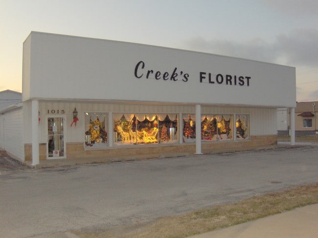
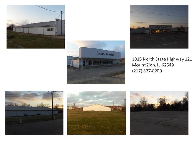
Property Record
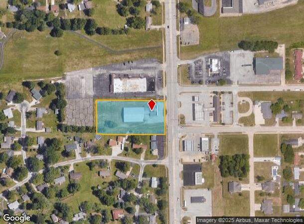
1015 N State Route 121, Mt Zion, IL 62549
NEARBY LISTINGS FOR SALE OR LEASE
Property Detail
1015 N State Route 121
12-17-04-234-023
W435.6 E468.29 S200 GOVT LOT 2 NE1/4 EXC HIWAY ROW 58 12 1 01 0218 000 00
Storebuilding
Macon
X
Illinois
17139C0025D
2
2024
1.90 AC
2024
Other Market Areas
002500
Decatur, IL
DEMOGRAPHICS near 1015 N State Route 121
1 Mile
3 Mile
5 Mile
2024 Total Population
4,307
11,382
25,460
2029 Population
4,173
10,977
24,532
Pop Growth 2024-2029
(3.11%)
(3.56%)
(3.64%)
Average Age
42
43
44
2024 Total Households
1,754
4,563
11,021
HH Growth 2024-2029
(3.14%)
(3.59%)
(3.69%)
Median Household Inc
$84,683
$86,493
$72,059
Avg Household Size
2.40
2.40
2.30
2024 Avg HH Vehicles
2.00
2.00
2.00
Median Home Value
$162,048
$175,028
$147,965
Median Year Built
1974
1974
1968
Nearby Places
Map Layers
Map Styles
 Street
 Aerial
- Restaurants
- Banks
- Shops
- Fitness
- Groceries
SALE & LEASE HISTORY
LISTING DATE
SALE/LEASE

Oct 24, 2016
For Sale
Jun 07, 2017
For Sale
Jul 28, 2017
For Sale
Jul 28, 2017
For Sale
Jul 27, 2017
For Sale
Jul 26, 2017
For Sale
Jan 09, 2017
For Sale
Nearby Properties
Address
Land Use
TOTAL SIZE
Lot Size
Zoning
Address
Land Use
TOTAL SIZE
Lot Size
Zoning
23.63 AC
MUNICIPAL
Address
Land Use
TOTAL SIZE
Lot Size
Zoning
98.53 AC
M-2
Address
Land Use
TOTAL SIZE
Lot Size
Zoning
6.36 AC
MUNICIPAL
Address
Land Use
TOTAL SIZE
Lot Size
Zoning
2.61 AC
MUNICIPAL
Address
Land Use
TOTAL SIZE
Lot Size
Zoning
21,555 SF
4.99 AC
MUNICIPAL
Address
Land Use
TOTAL SIZE
Lot Size
Zoning
1.24 AC
MUNICIPAL
Address
Land Use
TOTAL SIZE
Lot Size
Zoning
4.05 AC
MUNICIPAL
Address
Land Use
TOTAL SIZE
Lot Size
Zoning
1.24 AC
MUNICIPAL
Address
Land Use
TOTAL SIZE
Lot Size
Zoning
6.28 AC
MUNICIPAL
Address
Land Use
TOTAL SIZE
Lot Size
Zoning
3.47 AC
MUNICIPAL
Address
Land Use
TOTAL SIZE
Lot Size
Zoning
8.22 AC
MUNICIPAL
Address
Land Use
TOTAL SIZE
Lot Size
Zoning
6.96 AC
MUNICIPAL
Address
Land Use
TOTAL SIZE
Lot Size
Zoning
2.21 AC
MUNICIPAL
Address
Land Use
TOTAL SIZE
Lot Size
Zoning
1,300 SF
62 AC
A-1
Address
Land Use
TOTAL SIZE
Lot Size
Zoning
2.24 AC
MUNICIPAL
Address
Land Use
TOTAL SIZE
Lot Size
Zoning
1.67 AC
MUNICIPAL
Address
Land Use
TOTAL SIZE
Lot Size
Zoning
0.85 AC
MUNICIPAL
Address
Land Use
TOTAL SIZE
Lot Size
Zoning
7.87 AC
MUNICIPAL
Address
Land Use
TOTAL SIZE
Lot Size
Zoning
5,544 SF
1.30 AC
MUNICIPAL
Address
Land Use
TOTAL SIZE
Lot Size
Zoning
1.70 AC
MUNICIPAL
Address
Land Use
TOTAL SIZE
Lot Size
Zoning
2.08 AC
MUNICIPAL
Address
Land Use
TOTAL SIZE
Lot Size
Zoning
7.63 AC
MUNICIPAL
Address
Land Use
TOTAL SIZE
Lot Size
Zoning
1.79 AC
MUNICIPAL
Address
Land Use
TOTAL SIZE
Lot Size
Zoning
7.11 AC
MUNICIPAL
Address
Land Use
TOTAL SIZE
Lot Size
Zoning
20,108 SF
1.25 AC
MUNICIPAL
Address
Land Use
TOTAL SIZE
Lot Size
Zoning
2.66 AC
MUNICIPAL
Address
Land Use
TOTAL SIZE
Lot Size
Zoning
14,894 SF
1.34 AC
MUNICIPAL
Address
Land Use
TOTAL SIZE
Lot Size
Zoning
0.97 AC
MUNICIPAL
Address
Land Use
TOTAL SIZE
Lot Size
Zoning
10.97 AC
MUNICIPAL
Address
Land Use
TOTAL SIZE
Lot Size
Zoning
5.66 AC
MUNICIPAL
The World's #1 Commercial Real Estate Marketplace
Connect with us
© 2025 CoStar Group
The information above has been obtained from sources believed reliable. While we do not doubt its accuracy we have not verified it and make no guarantee, warranty or representation about it. It is your responsibility to independently confirm its accuracy and completeness. Any projections, opinions, assumptions, or estimates used are for example only and do not represent the current or future performance of the property. The value of this transaction to you depends on tax and other factors which should be evaluated by your tax, financial, and legal advisors. You and your advisors should conduct a careful, independent investigation of the property to determine to your satisfaction the suitability of the property for your needs.