Property Record
1015 Ne Romane Pl, Beaverton, OR 97006
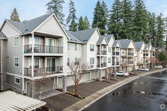

Property Detail
1015 Ne Romane Pl
R0726833
ACRES 6.70
Apartment
Washington
SCR-MD
Oregon
B and X Area of moderate flood hazard, usually the area between the limits of the 100-year and 500-year floods.
6.70 AC
2024
Sommerset West-Elmonica South
2026
Portland
031625
Portland-Vancouver-Hillsboro, OR-WA
264,648 SF
NEARBY LISTINGS FOR SALE OR LEASE
DEMOGRAPHICS near 1015 Ne Romane Pl
1 mile
3 mile
5 mile
2025 Total Population
21,688
139,181
293,525
2030 Population
21,854
140,756
297,122
Pop Growth 2025-2030
+ 0.77%
+ 1.13%
+ 1.23%
Average Age
36
38
39
2025 Total Households
9,607
53,867
109,511
HH Growth 2025-2030
+ 0.93%
+ 1.29%
+ 1.34%
Median Household Inc
$101,201
$105,046
$106,534
Avg Household Size
2.20
2.50
2.60
2025 Avg HH Vehicles
2.00
2.00
2.00
Median Home Value
$480,969
$570,848
$605,666
Median Year Built
2005
1995
1993
Nearby Places
Map Layers
Map Styles
 Street
 Aerial
Layers
 Traffic
 Biking
Places
Listings with unknown addresses are not visible on the map
- Restaurants
- Banks
- Shops
- Fitness
- Groceries
PUBLIC TRANSPORTATION
TRANSIT/SUBWAY
Quatama/Nw 205Th Avenue (MAX Blue Line - Tri-County Metropolitan Transportation District of Oregon Rail (TriMet Rail))
Drive
Walk
Distance
Quatama/Nw 205Th Avenue (MAX Blue Line - Tri-County Metropolitan Transportation District of Oregon Rail (TriMet Rail))
2 min
15 min
0.8 mi
COMMUTER RAIL
Beaverton Transit Center (West Side Express) (Westside Express Service - Tri-County Metropolitan Transportation District of Oregon Rail (TriMet Rail))
Drive
Walk
Distance
Beaverton Transit Center (West Side Express) (Westside Express Service - Tri-County Metropolitan Transportation District of Oregon Rail (TriMet Rail))
13 min
6.5 mi
Hall/Nimbus (Westside Express Service - Tri-County Metropolitan Transportation District of Oregon Rail (TriMet Rail))
Drive
Walk
Distance
Hall/Nimbus (Westside Express Service - Tri-County Metropolitan Transportation District of Oregon Rail (TriMet Rail))
17 min
9.2 mi
AIRPORT
Portland International
Drive
Walk
Distance
Portland International
40 min
25.3 mi
Freight Ports
Port of Portland
Drive
Walk
Distance
Port of Portland
24 min
14.3 mi
Nearby Properties
Address
Land Use
TOTAL SIZE
Lot Size
Zoning
Address
Land Use
TOTAL SIZE
Lot Size
Zoning
21.21 AC
I-P
Address
Land Use
TOTAL SIZE
Lot Size
Zoning
0.13 AC
I-P
Address
Land Use
TOTAL SIZE
Lot Size
Zoning
4,603 SF
90.28 AC
I-S
Address
Land Use
TOTAL SIZE
Lot Size
Zoning
337.91 AC
I-P
Address
Land Use
TOTAL SIZE
Lot Size
Zoning
14.02 AC
Address
Land Use
TOTAL SIZE
Lot Size
Zoning
35.87 AC
SSID
Address
Land Use
TOTAL SIZE
Lot Size
Zoning
37.93 AC
I-S
Address
Land Use
TOTAL SIZE
Lot Size
Zoning
373,884 SF
153.56 AC
UC-RP
Address
Land Use
TOTAL SIZE
Lot Size
Zoning
1,004,655 SF
24.55 AC
SCR-V
Address
Land Use
TOTAL SIZE
Lot Size
Zoning
47.85 AC
I-P
Address
Land Use
TOTAL SIZE
Lot Size
Zoning
Address
Land Use
TOTAL SIZE
Lot Size
Zoning
0.10 AC
IS
Address
Land Use
TOTAL SIZE
Lot Size
Zoning
2,016 SF
0.10 AC
I-S
Address
Land Use
TOTAL SIZE
Lot Size
Zoning
0.05 AC
I-S
Address
Land Use
TOTAL SIZE
Lot Size
Zoning
0.17 AC
I-P
Address
Land Use
TOTAL SIZE
Lot Size
Zoning
Address
Land Use
TOTAL SIZE
Lot Size
Zoning
292,000 SF
53.23 AC
I-G
Address
Land Use
TOTAL SIZE
Lot Size
Zoning
0.03 AC
I-P
Address
Land Use
TOTAL SIZE
Lot Size
Zoning
4,603 SF
0.09 AC
I-S
Address
Land Use
TOTAL SIZE
Lot Size
Zoning
316,321 SF
0.11 AC
I-P
Address
Land Use
TOTAL SIZE
Lot Size
Zoning
20.33 AC
I-S
Address
Land Use
TOTAL SIZE
Lot Size
Zoning
37.66 AC
IND
Address
Land Use
TOTAL SIZE
Lot Size
Zoning
174,233 SF
14.74 AC
I-P
Address
Land Use
TOTAL SIZE
Lot Size
Zoning
791,581 SF
22.58 AC
MFR-3
Address
Land Use
TOTAL SIZE
Lot Size
Zoning
53.13 AC
SC-BP
Address
Land Use
TOTAL SIZE
Lot Size
Zoning
2,822 SF
13.23 AC
Address
Land Use
TOTAL SIZE
Lot Size
Zoning
53.49 AC
SCFI
Address
Land Use
TOTAL SIZE
Lot Size
Zoning
281,695 SF
7.41 AC
SC-HDR
Address
Land Use
TOTAL SIZE
Lot Size
Zoning
482,173 SF
14.99 AC
C-G
The World's #1 Commercial Real Estate Marketplace
Connect with us
© 2026 CoStar Group
The information above has been obtained from sources believed reliable. While we do not doubt its accuracy we have not verified it and make no guarantee, warranty or representation about it. It is your responsibility to independently confirm its accuracy and completeness. Any projections, opinions, assumptions, or estimates used are for example only and do not represent the current or future performance of the property. The value of this transaction to you depends on tax and other factors which should be evaluated by your tax, financial, and legal advisors. You and your advisors should conduct a careful, independent investigation of the property to determine to your satisfaction the suitability of the property for your needs.