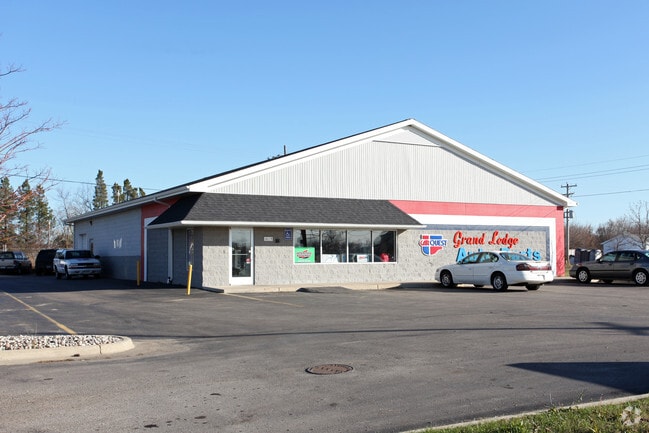
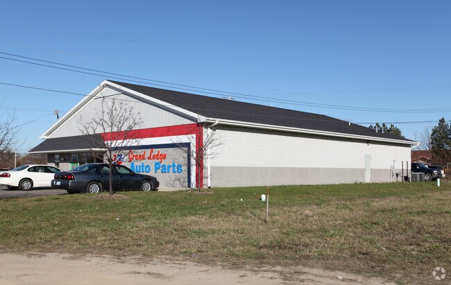
Property Record
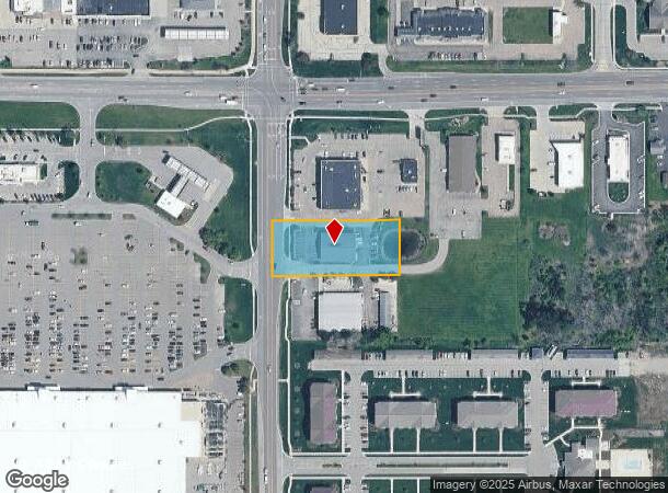
1015 S Clinton St, Grand Ledge, MI 48837
NEARBY LISTINGS FOR SALE OR LEASE
Property Detail
1015 S Clinton St
400-013-100-020-04
COM NW COR SEC 13, S 00 DEG 00'48"W 346.5 FT TO POB, N 89 DEG 50'35"E 333 FT, S 00 DEG 00'48"W 143.5 FT, S 89 DEG 50'35"W 333 FT, N 00 DEG 00'48" E 143.5 FT TO POB. TOGETHER WITH & SUBJ TO R/W FOR INGRESS & EGRESS. SEC 13, T4N,R4W, CITY OF GRAND LEDG
Storebuilding
Eaton
X
Michigan
26065C0105D
1.10 AC
2024
Outlying Eaton County
2025
West Michigan
020402
Lansing-East Lansing, MI
6,300 SF
DEMOGRAPHICS near 1015 S Clinton St
1 Mile
3 Mile
5 Mile
2024 Total Population
5,094
16,366
29,352
2029 Population
5,164
16,442
29,374
Pop Growth 2024-2029
+ 1.37%
+ 0.46%
+ 0.07%
Average Age
44
42
43
2024 Total Households
2,220
6,726
12,665
HH Growth 2024-2029
+ 1.49%
+ 0.52%
+ 0.09%
Median Household Inc
$67,359
$80,742
$78,352
Avg Household Size
2.20
2.40
2.30
2024 Avg HH Vehicles
2.00
2.00
2.00
Median Home Value
$208,163
$225,696
$226,031
Median Year Built
1975
1976
1982
Nearby Places
- Restaurants
- Banks
- Shops
- Fitness
- Groceries
PUBLIC TRANSPORTATION
AIRPORT
Capital Region International
DRIVE
WALK
Distance
Capital Region International
18 min
11.9 mi
Freight Ports
Port of Toledo
DRIVE
WALK
Distance
Port of Toledo
158 min
135.4 mi
Nearby Properties
Address
Land Use
TOTAL SIZE
Lot Size
Zoning
Address
Land Use
TOTAL SIZE
Lot Size
Zoning
238,602 SF
14.49 AC
Address
Land Use
TOTAL SIZE
Lot Size
Zoning
212,527 SF
23 AC
B-1
Address
Land Use
TOTAL SIZE
Lot Size
Zoning
1,536 SF
34.70 AC
A-2
Address
Land Use
TOTAL SIZE
Lot Size
Zoning
191,704 SF
16.30 AC
M-1 LI
Address
Land Use
TOTAL SIZE
Lot Size
Zoning
4.15 AC
R-PC
Address
Land Use
TOTAL SIZE
Lot Size
Zoning
37,659 SF
3.50 AC
B-1
Address
Land Use
TOTAL SIZE
Lot Size
Zoning
220,749 SF
39.81 AC
I-1
Address
Land Use
TOTAL SIZE
Lot Size
Zoning
76,835 SF
19.59 AC
NONE
Address
Land Use
TOTAL SIZE
Lot Size
Zoning
73,728 SF
4.35 AC
R-PC
Address
Land Use
TOTAL SIZE
Lot Size
Zoning
115.60 AC
I-1
Address
Land Use
TOTAL SIZE
Lot Size
Zoning
109,075 SF
6.26 AC
NONE
Address
Land Use
TOTAL SIZE
Lot Size
Zoning
51,896 SF
5.95 AC
NONE
Address
Land Use
TOTAL SIZE
Lot Size
Zoning
42,282 SF
10.73 AC
NONE
Address
Land Use
TOTAL SIZE
Lot Size
Zoning
47,466 SF
6.26 AC
B-2 COM
Address
Land Use
TOTAL SIZE
Lot Size
Zoning
4,854 SF
3.81 AC
B-1
Address
Land Use
TOTAL SIZE
Lot Size
Zoning
50,576 SF
6.24 AC
R-PC
Address
Land Use
TOTAL SIZE
Lot Size
Zoning
158,876 SF
11.73 AC
I-1
Address
Land Use
TOTAL SIZE
Lot Size
Zoning
11,632 SF
3.97 AC
AG
Address
Land Use
TOTAL SIZE
Lot Size
Zoning
9,056 SF
1.69 AC
B-1
Address
Land Use
TOTAL SIZE
Lot Size
Zoning
13,200 SF
I-1
Address
Land Use
TOTAL SIZE
Lot Size
Zoning
1,863 SF
112 AC
NONE
Address
Land Use
TOTAL SIZE
Lot Size
Zoning
51,312 SF
8.48 AC
R-M1MUL
Address
Land Use
TOTAL SIZE
Lot Size
Zoning
75.52 AC
NONE
Address
Land Use
TOTAL SIZE
Lot Size
Zoning
80,316 SF
4.19 AC
I-1
Address
Land Use
TOTAL SIZE
Lot Size
Zoning
13,650 SF
1.10 AC
B-1
Address
Land Use
TOTAL SIZE
Lot Size
Zoning
23,280 SF
3.91 AC
NONE
Address
Land Use
TOTAL SIZE
Lot Size
Zoning
36,000 SF
3 AC
B-1 COM
Address
Land Use
TOTAL SIZE
Lot Size
Zoning
12,275 SF
3.93 AC
NONE
Address
Land Use
TOTAL SIZE
Lot Size
Zoning
55,240 SF
4.50 AC
B-2 COM
Address
Land Use
TOTAL SIZE
Lot Size
Zoning
1,564 SF
86.99 AC
NONE
The World's #1 Commercial Real Estate Marketplace
Connect with us
© 2025 CoStar Group
The information above has been obtained from sources believed reliable. While we do not doubt its accuracy we have not verified it and make no guarantee, warranty or representation about it. It is your responsibility to independently confirm its accuracy and completeness. Any projections, opinions, assumptions, or estimates used are for example only and do not represent the current or future performance of the property. The value of this transaction to you depends on tax and other factors which should be evaluated by your tax, financial, and legal advisors. You and your advisors should conduct a careful, independent investigation of the property to determine to your satisfaction the suitability of the property for your needs.