Property Record
1015 S Hackett Rd, Waterloo, IA 50701
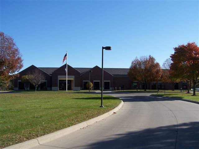

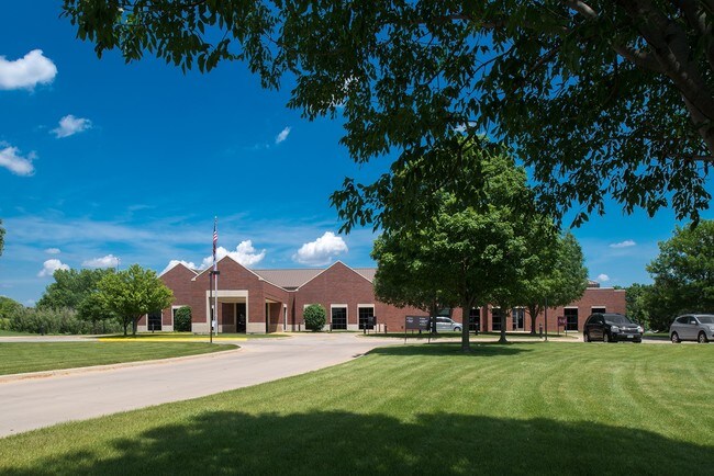
Property Detail
1015 S Hackett Rd
Waterloo-Cedar Falls, IA
PART OF SW 1/4 SEC 21 T 89 R 13 DESC AS FOL BEG AT NW COR OF ALABAR HILLS SECOND ADDN WHICH IS 165 FT W OF E LINE OF W 1/2 OF
8913-21-351-026
Black Hawk
Medicalbuilding
Iowa
B and X Area of moderate flood hazard, usually the area between the limits of the 100-year and 500-year floods.
1-7
2024
6.73 AC
2025
Iowa City/Waterloo
001502
Other Market Areas
25,401 SF
NEARBY LISTINGS FOR SALE OR LEASE
DEMOGRAPHICS near 1015 S Hackett Rd
1 mile
3 mile
5 mile
2025 Total Population
7,461
49,628
100,431
2030 Population
7,528
50,335
102,131
Pop Growth 2025-2030
+ 0.90%
+ 1.42%
+ 1.69%
Average Age
41
40
38
2025 Total Households
3,501
21,724
41,775
HH Growth 2025-2030
+ 1.00%
+ 1.51%
+ 1.75%
Median Household Inc
$64,867
$56,936
$57,273
Avg Household Size
2.10
2.20
2.30
2025 Avg HH Vehicles
2.00
2.00
2.00
Median Home Value
$159,385
$177,481
$180,864
Median Year Built
1967
1963
1964
Nearby Places
Map Layers
Map Styles
 Street
 Aerial
Transit
 Traffic
 Biking
Places
Listings with unknown addresses are not visible on the map
- Restaurants
- Banks
- Shops
- Fitness
- Groceries
SALE & LEASE HISTORY
LISTING DATE
SALE/LEASE

Sep 23, 2016
For Sale
Nov 01, 2016
For Lease
Nearby Properties
Address
Land Use
TOTAL SIZE
Lot Size
Zoning
Address
Land Use
TOTAL SIZE
Lot Size
Zoning
108,671 SF
3.72 AC
Address
Land Use
TOTAL SIZE
Lot Size
Zoning
88,541 SF
19.69 AC
Address
Land Use
TOTAL SIZE
Lot Size
Zoning
622 SF
106.81 AC
Address
Land Use
TOTAL SIZE
Lot Size
Zoning
117,384 SF
19.56 AC
Address
Land Use
TOTAL SIZE
Lot Size
Zoning
341 SF
1.83 AC
Address
Land Use
TOTAL SIZE
Lot Size
Zoning
124,305 SF
4.74 AC
Address
Land Use
TOTAL SIZE
Lot Size
Zoning
91,112 SF
2.01 AC
Address
Land Use
TOTAL SIZE
Lot Size
Zoning
200,574 SF
17.52 AC
Address
Land Use
TOTAL SIZE
Lot Size
Zoning
212,928 SF
20.87 AC
Address
Land Use
TOTAL SIZE
Lot Size
Zoning
119,827 SF
7.77 AC
Address
Land Use
TOTAL SIZE
Lot Size
Zoning
9,000 SF
21.25 AC
Address
Land Use
TOTAL SIZE
Lot Size
Zoning
20,600 SF
10.01 AC
Address
Land Use
TOTAL SIZE
Lot Size
Zoning
59,565 SF
0.28 AC
Address
Land Use
TOTAL SIZE
Lot Size
Zoning
8,000 SF
6.39 AC
Address
Land Use
TOTAL SIZE
Lot Size
Zoning
73,386 SF
2.02 AC
Address
Land Use
TOTAL SIZE
Lot Size
Zoning
125,340 SF
0.80 AC
Address
Land Use
TOTAL SIZE
Lot Size
Zoning
1,600 SF
9.01 AC
Address
Land Use
TOTAL SIZE
Lot Size
Zoning
1,600 SF
28.74 AC
Address
Land Use
TOTAL SIZE
Lot Size
Zoning
127,723 SF
10.53 AC
Address
Land Use
TOTAL SIZE
Lot Size
Zoning
11,828 SF
6.58 AC
Address
Land Use
TOTAL SIZE
Lot Size
Zoning
106,032 SF
8.22 AC
Address
Land Use
TOTAL SIZE
Lot Size
Zoning
60,275 SF
3.73 AC
Address
Land Use
TOTAL SIZE
Lot Size
Zoning
197,968 SF
6.10 AC
Address
Land Use
TOTAL SIZE
Lot Size
Zoning
2,466 SF
6.53 AC
Address
Land Use
TOTAL SIZE
Lot Size
Zoning
300 SF
46 AC
Address
Land Use
TOTAL SIZE
Lot Size
Zoning
70,933 SF
27.58 AC
Address
Land Use
TOTAL SIZE
Lot Size
Zoning
124,096 SF
16.46 AC
Address
Land Use
TOTAL SIZE
Lot Size
Zoning
18,000 SF
141.74 AC
Address
Land Use
TOTAL SIZE
Lot Size
Zoning
Address
Land Use
TOTAL SIZE
Lot Size
Zoning
76,644 SF
13.11 AC
The World's #1 Commercial Real Estate Marketplace
Connect with us
© 2026 CoStar Group
The information above has been obtained from sources believed reliable. While we do not doubt its accuracy we have not verified it and make no guarantee, warranty or representation about it. It is your responsibility to independently confirm its accuracy and completeness. Any projections, opinions, assumptions, or estimates used are for example only and do not represent the current or future performance of the property. The value of this transaction to you depends on tax and other factors which should be evaluated by your tax, financial, and legal advisors. You and your advisors should conduct a careful, independent investigation of the property to determine to your satisfaction the suitability of the property for your needs.