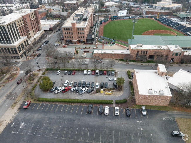
Property Record
1015 S Main St, Greenville, SC 29601
Current Lease Availabilities
NEARBY LISTINGS FOR SALE OR LEASE
Property Detail
1015 S Main St
Greenville-Anderson-Mauldin, SC
Allen Temple Ame Church
0073.00-04-015.00
MAP 0073.00
Religious
Greenville
X
South Carolina
45045C0383E
015.00
2025
1.68 AC
2024
West Greenville
000700
Greenville/Spartanburg
1,424 SF
DEMOGRAPHICS near 1015 S Main St
1 Mile
3 Mile
5 Mile
2024 Total Population
14,103
88,827
173,783
2029 Population
16,122
99,120
192,913
Pop Growth 2024-2029
+ 14.32%
+ 11.59%
+ 11.01%
Average Age
40
38
38
2024 Total Households
7,289
37,829
73,616
HH Growth 2024-2029
+ 14.43%
+ 11.82%
+ 11.21%
Median Household Inc
$66,166
$51,407
$52,213
Avg Household Size
1.90
2.20
2.30
2024 Avg HH Vehicles
1.00
2.00
2.00
Median Home Value
$396,016
$276,059
$243,523
Median Year Built
2010
1975
1979
Nearby Places
Map Layers
Map Styles
 Street
 Aerial
- Restaurants
- Banks
- Shops
- Fitness
- Groceries
PUBLIC TRANSPORTATION
COMMUTER RAIL
DRIVE
WALK
Distance
5 min
1.9 mi
AIRPORT
Greenville Spartanburg International
DRIVE
WALK
Distance
Greenville Spartanburg International
24 min
15.2 mi
Nearby Properties
Address
Land Use
TOTAL SIZE
Lot Size
Zoning
Address
Land Use
TOTAL SIZE
Lot Size
Zoning
14.21 AC
RM2
Address
Land Use
TOTAL SIZE
Lot Size
Zoning
0.45 AC
OD
Address
Land Use
TOTAL SIZE
Lot Size
Zoning
11.99 AC
RM2
Address
Land Use
TOTAL SIZE
Lot Size
Zoning
7.03 AC
OD
Address
Land Use
TOTAL SIZE
Lot Size
Zoning
1.01 AC
C4
Address
Land Use
TOTAL SIZE
Lot Size
Zoning
0.39 AC
C4
Address
Land Use
TOTAL SIZE
Lot Size
Zoning
28.88 AC
RM
Address
Land Use
TOTAL SIZE
Lot Size
Zoning
28.72 AC
C3
Address
Land Use
TOTAL SIZE
Lot Size
Zoning
0.47 AC
OD
Address
Land Use
TOTAL SIZE
Lot Size
Zoning
9.91 AC
C3
Address
Land Use
TOTAL SIZE
Lot Size
Zoning
6.17 AC
Address
Land Use
TOTAL SIZE
Lot Size
Zoning
114.75 AC
0D
Address
Land Use
TOTAL SIZE
Lot Size
Zoning
6.21 AC
C3
Address
Land Use
TOTAL SIZE
Lot Size
Zoning
1.92 AC
C4
Address
Land Use
TOTAL SIZE
Lot Size
Zoning
6.03 AC
OD
Address
Land Use
TOTAL SIZE
Lot Size
Zoning
20.04 AC
RM
Address
Land Use
TOTAL SIZE
Lot Size
Zoning
0.65 AC
OD
Address
Land Use
TOTAL SIZE
Lot Size
Zoning
0.53 AC
C4
Address
Land Use
TOTAL SIZE
Lot Size
Zoning
1.62 AC
C3
Address
Land Use
TOTAL SIZE
Lot Size
Zoning
11.13 AC
OD
Address
Land Use
TOTAL SIZE
Lot Size
Zoning
5.86 AC
RM2
Address
Land Use
TOTAL SIZE
Lot Size
Zoning
1.19 AC
C4
Address
Land Use
TOTAL SIZE
Lot Size
Zoning
5.60 AC
RM
Address
Land Use
TOTAL SIZE
Lot Size
Zoning
47.64 AC
R6
Address
Land Use
TOTAL SIZE
Lot Size
Zoning
4.67 AC
C3
Address
Land Use
TOTAL SIZE
Lot Size
Zoning
123.10 AC
0D
Address
Land Use
TOTAL SIZE
Lot Size
Zoning
0.45 AC
OD
Address
Land Use
TOTAL SIZE
Lot Size
Zoning
0.02 AC
C4
Address
Land Use
TOTAL SIZE
Lot Size
Zoning
9.57 AC
C3
Address
Land Use
TOTAL SIZE
Lot Size
Zoning
4.70 AC
RM
The World's #1 Commercial Real Estate Marketplace
Connect with us
© 2026 CoStar Group
The information above has been obtained from sources believed reliable. While we do not doubt its accuracy we have not verified it and make no guarantee, warranty or representation about it. It is your responsibility to independently confirm its accuracy and completeness. Any projections, opinions, assumptions, or estimates used are for example only and do not represent the current or future performance of the property. The value of this transaction to you depends on tax and other factors which should be evaluated by your tax, financial, and legal advisors. You and your advisors should conduct a careful, independent investigation of the property to determine to your satisfaction the suitability of the property for your needs.