Property Record
1015 S Quarry Rd, Willard, MO 65781

Save to a Folder
{{folder.Name}}
{{folder.ListingIds.length}} Properties
{{folder.ListingIds.length}} Property
Create a New Folder
Property Detail
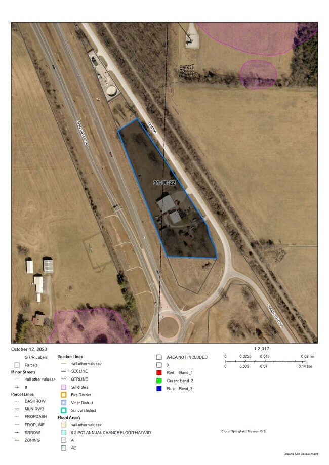
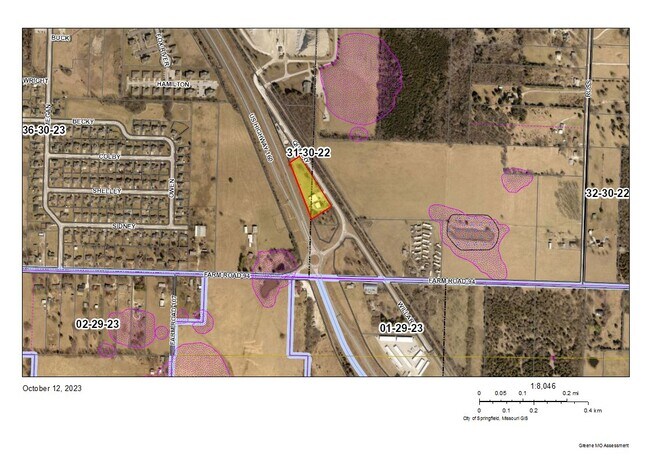
1015 S Quarry Rd
Springfield, MO
QUARRY ROAD ESTATES LOT 2
880831400043
GREENE
Commercialnec
Missouri
INC
2
B and X Area of moderate flood hazard, usually the area between the limits of the 100-year and 500-year floods.
2.24 AC
2025
Outlying Greene County
2025
Springfield
005002
NEARBY LISTINGS FOR SALE OR LEASE
-
-
View all Willard listings for sale on LoopNet.com
DEMOGRAPHICS near 1015 S Quarry Rd
1 mile
3 mile
5 mile
2025 Total Population
1,639
8,120
21,674
2030 Population
1,639
8,304
22,331
Pop Growth 2025-2030
0.00%
+ 2.27%
+ 3.03%
Average Age
38
39
39
2025 Total Households
663
3,075
8,468
HH Growth 2025-2030
+ 0.15%
+ 2.41%
+ 3.24%
Median Household Inc
$72,134
$77,288
$68,204
Avg Household Size
2.50
2.60
2.50
2025 Avg HH Vehicles
2.00
2.00
2.00
Median Home Value
$283,467
$256,545
$237,617
Median Year Built
1992
1989
1991
Nearby Places
Map Layers
Map Styles
 Street
 Aerial
Layers
 Traffic
 Biking
Places
Listings with unknown addresses are not visible on the map
- Restaurants
- Banks
- Shops
- Fitness
- Groceries
PUBLIC TRANSPORTATION
AIRPORT
Springfield-Branson Ntl
Drive
Walk
Distance
Springfield-Branson Ntl
8 min
2.8 mi
Freight Ports
Tulsa Port of Inola
Drive
Walk
Distance
Tulsa Port of Inola
191 min
172.1 mi
SALE & LEASE HISTORY
LISTING DATE
SALE/LEASE

Oct 13, 2023
For Sale
Nearby Properties
Address
Land Use
TOTAL SIZE
Lot Size
Zoning
Address
Land Use
TOTAL SIZE
Lot Size
Zoning
511.19 AC
Address
Land Use
TOTAL SIZE
Lot Size
Zoning
10.70 AC
INC
Address
Land Use
TOTAL SIZE
Lot Size
Zoning
238,700 SF
14.05 AC
INC
Address
Land Use
TOTAL SIZE
Lot Size
Zoning
267,740 SF
26.80 AC
M-1
Address
Land Use
TOTAL SIZE
Lot Size
Zoning
151,993 SF
16 AC
INC
Address
Land Use
TOTAL SIZE
Lot Size
Zoning
69,172 SF
19.28 AC
INC
Address
Land Use
TOTAL SIZE
Lot Size
Zoning
66,504 SF
7.01 AC
INC
Address
Land Use
TOTAL SIZE
Lot Size
Zoning
7 AC
INC
Address
Land Use
TOTAL SIZE
Lot Size
Zoning
29,400 SF
9.80 AC
PAD
Address
Land Use
TOTAL SIZE
Lot Size
Zoning
16.23 AC
INC
Address
Land Use
TOTAL SIZE
Lot Size
Zoning
5.71 AC
INC
Address
Land Use
TOTAL SIZE
Lot Size
Zoning
13.19 AC
INC
Address
Land Use
TOTAL SIZE
Lot Size
Zoning
11,727 SF
129.68 AC
INC
Address
Land Use
TOTAL SIZE
Lot Size
Zoning
55,253 SF
2.11 AC
INC
Address
Land Use
TOTAL SIZE
Lot Size
Zoning
11,240 SF
22.57 AC
A-1
Address
Land Use
TOTAL SIZE
Lot Size
Zoning
12,271 SF
1.33 AC
INC
Address
Land Use
TOTAL SIZE
Lot Size
Zoning
43,050 SF
3.43 AC
INC
Address
Land Use
TOTAL SIZE
Lot Size
Zoning
2.05 AC
INC.
Address
Land Use
TOTAL SIZE
Lot Size
Zoning
25,046 SF
6.37 AC
INC
Address
Land Use
TOTAL SIZE
Lot Size
Zoning
2 AC
INC
Address
Land Use
TOTAL SIZE
Lot Size
Zoning
24,695 SF
3.36 AC
INC
Address
Land Use
TOTAL SIZE
Lot Size
Zoning
1.62 AC
INC
Address
Land Use
TOTAL SIZE
Lot Size
Zoning
31,824 SF
8 AC
INC
Address
Land Use
TOTAL SIZE
Lot Size
Zoning
8 AC
INC
Address
Land Use
TOTAL SIZE
Lot Size
Zoning
1.19 AC
INC
Address
Land Use
TOTAL SIZE
Lot Size
Zoning
1,335 SF
1.07 AC
INC
Address
Land Use
TOTAL SIZE
Lot Size
Zoning
Address
Land Use
TOTAL SIZE
Lot Size
Zoning
5,090 SF
1.35 AC
INC
Address
Land Use
TOTAL SIZE
Lot Size
Zoning
1,120 SF
135.30 AC
INC
Address
Land Use
TOTAL SIZE
Lot Size
Zoning
The World's #1 Commercial Real Estate Marketplace
Connect with us
© 2026 CoStar Group
The information above has been obtained from sources believed reliable. While we do not doubt its accuracy we have not verified it and make no guarantee, warranty or representation about it. It is your responsibility to independently confirm its accuracy and completeness. Any projections, opinions, assumptions, or estimates used are for example only and do not represent the current or future performance of the property. The value of this transaction to you depends on tax and other factors which should be evaluated by your tax, financial, and legal advisors. You and your advisors should conduct a careful, independent investigation of the property to determine to your satisfaction the suitability of the property for your needs.