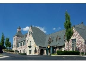
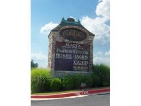
Property Record
1015 State Highway 248, Branson, MO 65616

Current Lease Availabilities
Property Detail
1015 State Highway 248
08-9.0-29-000-000-033.007
PT NWSW4 S OF MSH 248; CITY OF BRANSON
Commercialnec
Taney
B and X Area of moderate flood hazard, usually the area between the limits of the 100-year and 500-year floods.
Missouri
2024
1.81 AC
2025
Branson
480206
Other Market Areas
16,962 SF
Branson, MO
NEARBY LISTINGS FOR SALE OR LEASE
DEMOGRAPHICS near 1015 State Highway 248
1 mile
3 mile
5 mile
2025 Total Population
2,077
17,468
32,432
2030 Population
2,025
17,370
32,409
Pop Growth 2025-2030
(2.50%)
(0.56%)
(0.07%)
Average Age
41
40
41
2025 Total Households
852
6,741
12,971
HH Growth 2025-2030
(2.58%)
(0.55%)
+ 0.02%
Median Household Inc
$66,346
$61,321
$59,790
Avg Household Size
2.30
2.30
2.30
2025 Avg HH Vehicles
2.00
2.00
2.00
Median Home Value
$280,969
$252,780
$243,605
Median Year Built
1995
1994
1995
Nearby Places
Map Layers
Map Styles
 Street
 Aerial
Layers
 Traffic
 Biking
Places
Listings with unknown addresses are not visible on the map
- Restaurants
- Banks
- Shops
- Fitness
- Groceries
Nearby Properties
Address
Land Use
TOTAL SIZE
Lot Size
Zoning
Address
Land Use
TOTAL SIZE
Lot Size
Zoning
50,417 SF
17.43 AC
Address
Land Use
TOTAL SIZE
Lot Size
Zoning
350,270 SF
40 AC
Address
Land Use
TOTAL SIZE
Lot Size
Zoning
66,272 SF
7.83 AC
Address
Land Use
TOTAL SIZE
Lot Size
Zoning
140,093 SF
8.37 AC
Address
Land Use
TOTAL SIZE
Lot Size
Zoning
59,939 SF
15.76 AC
Address
Land Use
TOTAL SIZE
Lot Size
Zoning
Address
Land Use
TOTAL SIZE
Lot Size
Zoning
26,658 SF
6.30 AC
Address
Land Use
TOTAL SIZE
Lot Size
Zoning
43,276 SF
5.93 AC
Address
Land Use
TOTAL SIZE
Lot Size
Zoning
18,781 SF
4.70 AC
Address
Land Use
TOTAL SIZE
Lot Size
Zoning
123,377 SF
13.05 AC
Address
Land Use
TOTAL SIZE
Lot Size
Zoning
63,890 SF
14.45 AC
Address
Land Use
TOTAL SIZE
Lot Size
Zoning
27,496 SF
3.34 AC
Address
Land Use
TOTAL SIZE
Lot Size
Zoning
104,868 SF
13.61 AC
Address
Land Use
TOTAL SIZE
Lot Size
Zoning
12,542 SF
3.87 AC
Address
Land Use
TOTAL SIZE
Lot Size
Zoning
19,872 SF
2.97 AC
Address
Land Use
TOTAL SIZE
Lot Size
Zoning
45,680 SF
11.85 AC
Address
Land Use
TOTAL SIZE
Lot Size
Zoning
25,760 SF
6.47 AC
Address
Land Use
TOTAL SIZE
Lot Size
Zoning
24,176 SF
10.28 AC
Address
Land Use
TOTAL SIZE
Lot Size
Zoning
53,728 SF
6.74 AC
Address
Land Use
TOTAL SIZE
Lot Size
Zoning
17,313 SF
5.18 AC
Address
Land Use
TOTAL SIZE
Lot Size
Zoning
48,182 SF
15 AC
Address
Land Use
TOTAL SIZE
Lot Size
Zoning
51,842 SF
3.48 AC
Address
Land Use
TOTAL SIZE
Lot Size
Zoning
44,871 SF
4.57 AC
Address
Land Use
TOTAL SIZE
Lot Size
Zoning
18,308 SF
2.59 AC
Address
Land Use
TOTAL SIZE
Lot Size
Zoning
1,804,046 SF
23.86 AC
Address
Land Use
TOTAL SIZE
Lot Size
Zoning
34,856 SF
15.68 AC
Address
Land Use
TOTAL SIZE
Lot Size
Zoning
51,904 SF
5.08 AC
Address
Land Use
TOTAL SIZE
Lot Size
Zoning
28,639 SF
2.51 AC
Address
Land Use
TOTAL SIZE
Lot Size
Zoning
15,605 SF
3.13 AC
The World's #1 Commercial Real Estate Marketplace
Connect with us
© 2026 CoStar Group
The information above has been obtained from sources believed reliable. While we do not doubt its accuracy we have not verified it and make no guarantee, warranty or representation about it. It is your responsibility to independently confirm its accuracy and completeness. Any projections, opinions, assumptions, or estimates used are for example only and do not represent the current or future performance of the property. The value of this transaction to you depends on tax and other factors which should be evaluated by your tax, financial, and legal advisors. You and your advisors should conduct a careful, independent investigation of the property to determine to your satisfaction the suitability of the property for your needs.