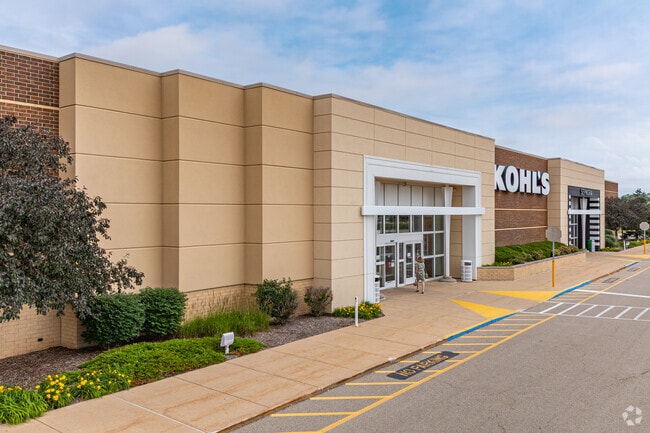
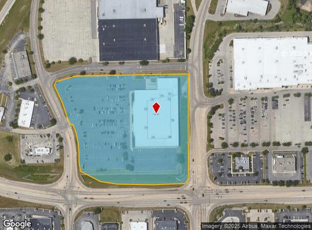
Property Record
10153 N 2Nd St, Machesney Park, IL 61115

NEARBY LISTINGS FOR SALE OR LEASE
Property Detail
10153 N 2Nd St
Rockford, IL
Gateway Of Machesney Park
08-20-133-043
REPLAT PT LTS 2-3-4 OF FINAL PLAT OF GATEWAY OF MACHESNEY PARK PT NW1/4 SEC20-45-2 (EXC ROW BY 2011-1033427) LOT6
Commercialnec
Winnebago
AE
Illinois
17201C0257E
2-3
2024
9.32 AC
2024
I-39 Corr/Winnebago Cnty
003805
Chicago
96,564 SF
DEMOGRAPHICS near 10153 N 2Nd St
1 Mile
3 Mile
5 Mile
2024 Total Population
3,525
34,951
80,744
2029 Population
3,458
34,437
79,319
Pop Growth 2024-2029
(1.90%)
(1.47%)
(1.76%)
Average Age
44
41
42
2024 Total Households
1,372
14,115
33,288
HH Growth 2024-2029
(1.90%)
(1.49%)
(1.79%)
Median Household Inc
$71,866
$68,560
$67,911
Avg Household Size
2.50
2.40
2.40
2024 Avg HH Vehicles
2.00
2.00
2.00
Median Home Value
$152,260
$146,044
$159,858
Median Year Built
1977
1980
1980
Nearby Places
Map Layers
Map Styles
 Street
 Aerial
- Restaurants
- Banks
- Shops
- Fitness
- Groceries
PUBLIC TRANSPORTATION
AIRPORT
Chicago/Rockford International
DRIVE
WALK
Distance
Chicago/Rockford International
30 min
16.7 mi
Freight Ports
Port Milwaukee
DRIVE
WALK
Distance
Port Milwaukee
103 min
85.6 mi
Nearby Properties
Address
Land Use
TOTAL SIZE
Lot Size
Zoning
Address
Land Use
TOTAL SIZE
Lot Size
Zoning
189,000 SF
56.75 AC
IL - INDUS
Address
Land Use
TOTAL SIZE
Lot Size
Zoning
105,664 SF
13.34 AC
Address
Land Use
TOTAL SIZE
Lot Size
Zoning
Address
Land Use
TOTAL SIZE
Lot Size
Zoning
51,580 SF
6.13 AC
Address
Land Use
TOTAL SIZE
Lot Size
Zoning
192,604 SF
17.05 AC
Address
Land Use
TOTAL SIZE
Lot Size
Zoning
112,035 SF
8.79 AC
Address
Land Use
TOTAL SIZE
Lot Size
Zoning
175,502 SF
18.15 AC
Address
Land Use
TOTAL SIZE
Lot Size
Zoning
Address
Land Use
TOTAL SIZE
Lot Size
Zoning
Address
Land Use
TOTAL SIZE
Lot Size
Zoning
125,024 SF
9.91 AC
Address
Land Use
TOTAL SIZE
Lot Size
Zoning
140,085 SF
14.90 AC
Address
Land Use
TOTAL SIZE
Lot Size
Zoning
124,757 SF
13.41 AC
Address
Land Use
TOTAL SIZE
Lot Size
Zoning
16,500 SF
10.62 AC
Address
Land Use
TOTAL SIZE
Lot Size
Zoning
140,888 SF
7.96 AC
Address
Land Use
TOTAL SIZE
Lot Size
Zoning
103,326 SF
10.52 AC
Address
Land Use
TOTAL SIZE
Lot Size
Zoning
Address
Land Use
TOTAL SIZE
Lot Size
Zoning
135,351 SF
19 AC
Address
Land Use
TOTAL SIZE
Lot Size
Zoning
10.16 AC
Address
Land Use
TOTAL SIZE
Lot Size
Zoning
85,350 SF
13.15 AC
Address
Land Use
TOTAL SIZE
Lot Size
Zoning
55,200 SF
10.17 AC
Address
Land Use
TOTAL SIZE
Lot Size
Zoning
79,643 SF
3.55 AC
Address
Land Use
TOTAL SIZE
Lot Size
Zoning
Address
Land Use
TOTAL SIZE
Lot Size
Zoning
150,000 SF
5.64 AC
Address
Land Use
TOTAL SIZE
Lot Size
Zoning
87,748 SF
7.80 AC
Address
Land Use
TOTAL SIZE
Lot Size
Zoning
4,180 SF
44.85 AC
Address
Land Use
TOTAL SIZE
Lot Size
Zoning
52.23 AC
Address
Land Use
TOTAL SIZE
Lot Size
Zoning
30,090 SF
4.06 AC
Address
Land Use
TOTAL SIZE
Lot Size
Zoning
13.03 AC
Address
Land Use
TOTAL SIZE
Lot Size
Zoning
111,172 SF
19.33 AC
CR- COMM
Address
Land Use
TOTAL SIZE
Lot Size
Zoning
129,060 SF
7.09 AC
The World's #1 Commercial Real Estate Marketplace
Connect with us
© 2026 CoStar Group
The information above has been obtained from sources believed reliable. While we do not doubt its accuracy we have not verified it and make no guarantee, warranty or representation about it. It is your responsibility to independently confirm its accuracy and completeness. Any projections, opinions, assumptions, or estimates used are for example only and do not represent the current or future performance of the property. The value of this transaction to you depends on tax and other factors which should be evaluated by your tax, financial, and legal advisors. You and your advisors should conduct a careful, independent investigation of the property to determine to your satisfaction the suitability of the property for your needs.