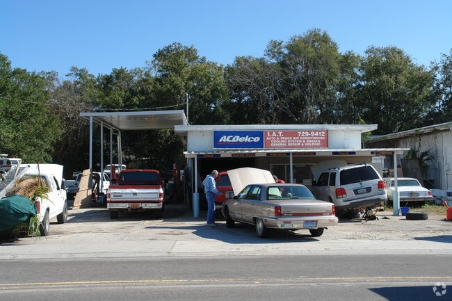
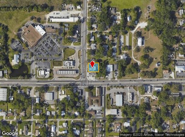
Property Record
1016 36Th Ave E, Ellenton, FL 34222

NEARBY LISTINGS FOR SALE OR LEASE
Property Detail
1016 36Th Ave E
North Port-Bradenton-Sarasota, FL
Plat Of Ellenton Pb1/133
9573-0000-7
BEG AT SW COR OF LOT P, TH RUN N 115 FT FOR A POB, E 120 FT, N 100 FT M/L TO N LN OF LOT P, W 120 FT, TH RUN S TO POB (P-66) PLAT OF ELLENTON VILLAGE PI#9573.0000/7
Autorepair
Manatee
X
Florida
12081C0169F
p
2023
0.28 AC
2025
Manatee
001904
Tampa/St Petersburg
2,608 SF
DEMOGRAPHICS near 1016 36Th Ave E
1 mile
3 mile
5 mile
2024 Total Population
4,148
60,553
154,324
2029 Population
4,911
71,150
180,737
Pop Growth 2024-2029
+ 18.39%
+ 17.50%
+ 17.12%
Average Age
46
43
44
2024 Total Households
1,713
24,233
61,220
HH Growth 2024-2029
+ 17.51%
+ 16.75%
+ 16.43%
Median Household Inc
$58,654
$56,016
$58,599
Avg Household Size
2.30
2.40
2.40
2024 Avg HH Vehicles
2.00
2.00
2.00
Median Home Value
$319,473
$231,001
$247,921
Median Year Built
1983
1992
1989
Nearby Places
Map Layers
Map Styles
 Street
 Aerial
Transit
 Traffic
 Biking
Places
Listings with unknown addresses are not visible on the map
- Restaurants
- Banks
- Shops
- Fitness
- Groceries
PUBLIC TRANSPORTATION
AIRPORT
Sarasota/Bradenton International
Drive
Walk
Distance
Sarasota/Bradenton International
23 min
12.1 mi
St Pete-Clearwater International
Drive
Walk
Distance
St Pete-Clearwater International
52 min
35.8 mi
Tampa International
Drive
Walk
Distance
Tampa International
59 min
43.7 mi
SALE & LEASE HISTORY
LISTING DATE
SALE/LEASE

Aug 04, 2021
For Sale
Nearby Properties
Address
Land Use
TOTAL SIZE
Lot Size
Zoning
Address
Land Use
TOTAL SIZE
Lot Size
Zoning
622,266 SF
68.76 AC
PD-MU
Address
Land Use
TOTAL SIZE
Lot Size
Zoning
881,490 SF
83.09 AC
BR_R-3
Address
Land Use
TOTAL SIZE
Lot Size
Zoning
595,475 SF
16.90 AC
BR_T5
Address
Land Use
TOTAL SIZE
Lot Size
Zoning
349,711 SF
49.51 AC
BR_SD1
Address
Land Use
TOTAL SIZE
Lot Size
Zoning
359,241 SF
27.68 AC
PD-MU
Address
Land Use
TOTAL SIZE
Lot Size
Zoning
405,843 SF
9.09 AC
BR_T5
Address
Land Use
TOTAL SIZE
Lot Size
Zoning
277,678 SF
7.80 AC
BR_T4-O, B
Address
Land Use
TOTAL SIZE
Lot Size
Zoning
319,679 SF
31.78 AC
BR_R-1
Address
Land Use
TOTAL SIZE
Lot Size
Zoning
427,250 SF
38.18 AC
A-1 SUBURB
Address
Land Use
TOTAL SIZE
Lot Size
Zoning
98,722 SF
10.24 AC
PL_P
Address
Land Use
TOTAL SIZE
Lot Size
Zoning
169,485 SF
7.87 AC
PD-MU
Address
Land Use
TOTAL SIZE
Lot Size
Zoning
318,507 SF
10.47 AC
BR_T4R,BR_
Address
Land Use
TOTAL SIZE
Lot Size
Zoning
2,401,721 SF
142.14 AC
PD-UI
Address
Land Use
TOTAL SIZE
Lot Size
Zoning
311,669 SF
34.55 AC
BR_R-2
Address
Land Use
TOTAL SIZE
Lot Size
Zoning
225,768 SF
18.47 AC
BR_R-1
Address
Land Use
TOTAL SIZE
Lot Size
Zoning
257,072 SF
10.07 AC
BR_T5
Address
Land Use
TOTAL SIZE
Lot Size
Zoning
456,375 SF
112.07 AC
PD-MU
Address
Land Use
TOTAL SIZE
Lot Size
Zoning
4,845 SF
82.48 AC
RSMH-6
Address
Land Use
TOTAL SIZE
Lot Size
Zoning
541,781 SF
3.48 AC
BR_T5
Address
Land Use
TOTAL SIZE
Lot Size
Zoning
885,776 SF
46.22 AC
LM LIGHT M
Address
Land Use
TOTAL SIZE
Lot Size
Zoning
270,900 SF
44.35 AC
PD-MU
Address
Land Use
TOTAL SIZE
Lot Size
Zoning
456,317 SF
46.75 AC
PD-R
Address
Land Use
TOTAL SIZE
Lot Size
Zoning
276,469 SF
10.90 AC
PD-MU
Address
Land Use
TOTAL SIZE
Lot Size
Zoning
16,472 SF
67.82 AC
RSMH-6
Address
Land Use
TOTAL SIZE
Lot Size
Zoning
191,100 SF
30.35 AC
PD-C
Address
Land Use
TOTAL SIZE
Lot Size
Zoning
3,168 SF
60.92 AC
RSMH-6
Address
Land Use
TOTAL SIZE
Lot Size
Zoning
17,233 SF
74.95 AC
RSMH-4.5
Address
Land Use
TOTAL SIZE
Lot Size
Zoning
229,863 SF
31.01 AC
PL_CG,PL_C
Address
Land Use
TOTAL SIZE
Lot Size
Zoning
257,697 SF
5.32 AC
PL_PD-H
Address
Land Use
TOTAL SIZE
Lot Size
Zoning
6,151 SF
26.50 AC
PL_MHP-1
The World's #1 Commercial Real Estate Marketplace
Connect with us
© 2026 CoStar Group
The information above has been obtained from sources believed reliable. While we do not doubt its accuracy we have not verified it and make no guarantee, warranty or representation about it. It is your responsibility to independently confirm its accuracy and completeness. Any projections, opinions, assumptions, or estimates used are for example only and do not represent the current or future performance of the property. The value of this transaction to you depends on tax and other factors which should be evaluated by your tax, financial, and legal advisors. You and your advisors should conduct a careful, independent investigation of the property to determine to your satisfaction the suitability of the property for your needs.