Property Record
1016 Bypass N, Lawrenceburg, KY 40342
NEARBY LISTINGS FOR SALE OR LEASE
-
-
View all Lawrenceburg listings for sale on LoopNet.com
Property Detail
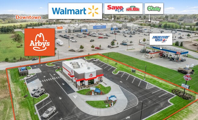
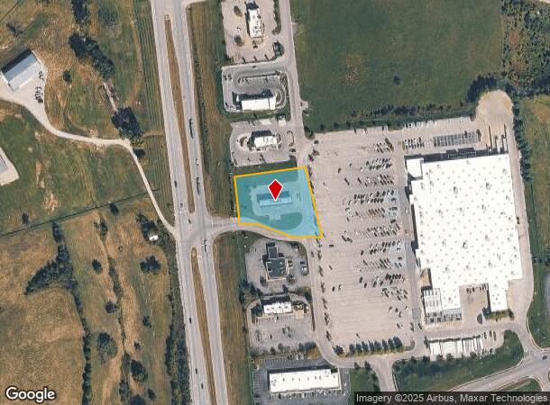
1016 Bypass N
Frankfort, KY
MURPHY OIL & LT 4 BYPASS N & HWY 44
49-61-06-004
Anderson
Commercialnec
Kentucky
X
4
21005C0120D
0.99 AC
2024
Kentucky East Area
2024
Other Market Areas
950101
DEMOGRAPHICS near 1016 Bypass N
1 Mile
3 Mile
5 Mile
2024 Total Population
3,439
15,384
19,921
2029 Population
3,553
15,918
20,599
Pop Growth 2024-2029
+ 3.31%
+ 3.47%
+ 3.40%
Average Age
40
40
40
2024 Total Households
1,424
6,107
7,857
HH Growth 2024-2029
+ 3.30%
+ 3.44%
+ 3.39%
Median Household Inc
$39,923
$55,582
$59,198
Avg Household Size
2.30
2.50
2.50
2024 Avg HH Vehicles
2.00
2.00
2.00
Median Home Value
$154,968
$167,030
$178,414
Median Year Built
1980
1986
1987
Nearby Places
Map Layers
Map Styles
 Street
 Aerial
- Restaurants
- Banks
- Shops
- Fitness
- Groceries
PUBLIC TRANSPORTATION
AIRPORT
Blue Grass
DRIVE
WALK
Distance
Blue Grass
28 min
22.1 mi
Freight Ports
Port of Toledo
DRIVE
WALK
Distance
Port of Toledo
355 min
305.8 mi
SALE & LEASE HISTORY
LISTING DATE
SALE/LEASE

Oct 26, 2021
For Sale
Nearby Properties
Address
Land Use
TOTAL SIZE
Lot Size
Zoning
Address
Land Use
TOTAL SIZE
Lot Size
Zoning
288.73 AC
Address
Land Use
TOTAL SIZE
Lot Size
Zoning
Address
Land Use
TOTAL SIZE
Lot Size
Zoning
101,112 SF
58.80 AC
Address
Land Use
TOTAL SIZE
Lot Size
Zoning
81.12 AC
Address
Land Use
TOTAL SIZE
Lot Size
Zoning
155,627 SF
22.48 AC
COMMERCIAL
Address
Land Use
TOTAL SIZE
Lot Size
Zoning
51,271 SF
6.93 AC
Address
Land Use
TOTAL SIZE
Lot Size
Zoning
51,013 SF
9.21 AC
Address
Land Use
TOTAL SIZE
Lot Size
Zoning
173,200 SF
76 AC
COMMERCIAL
Address
Land Use
TOTAL SIZE
Lot Size
Zoning
24.07 AC
Address
Land Use
TOTAL SIZE
Lot Size
Zoning
0.50 AC
Address
Land Use
TOTAL SIZE
Lot Size
Zoning
Address
Land Use
TOTAL SIZE
Lot Size
Zoning
2.28 AC
Address
Land Use
TOTAL SIZE
Lot Size
Zoning
48,806 SF
5.51 AC
Address
Land Use
TOTAL SIZE
Lot Size
Zoning
28,396 SF
12.71 AC
Address
Land Use
TOTAL SIZE
Lot Size
Zoning
34,348 SF
2.51 AC
Address
Land Use
TOTAL SIZE
Lot Size
Zoning
1.85 AC
COMMERCIAL
Address
Land Use
TOTAL SIZE
Lot Size
Zoning
86,640 SF
4.61 AC
COMMERCIAL
Address
Land Use
TOTAL SIZE
Lot Size
Zoning
3.30 AC
COMMERCIAL
Address
Land Use
TOTAL SIZE
Lot Size
Zoning
17.68 AC
Address
Land Use
TOTAL SIZE
Lot Size
Zoning
46,140 SF
3.49 AC
Address
Land Use
TOTAL SIZE
Lot Size
Zoning
35.94 AC
COMMERCIAL
Address
Land Use
TOTAL SIZE
Lot Size
Zoning
Address
Land Use
TOTAL SIZE
Lot Size
Zoning
2.14 AC
Address
Land Use
TOTAL SIZE
Lot Size
Zoning
92,202 SF
33.15 AC
Address
Land Use
TOTAL SIZE
Lot Size
Zoning
12,000 SF
3.11 AC
Address
Land Use
TOTAL SIZE
Lot Size
Zoning
Address
Land Use
TOTAL SIZE
Lot Size
Zoning
0.85 AC
Address
Land Use
TOTAL SIZE
Lot Size
Zoning
4,920 SF
3.75 AC
Address
Land Use
TOTAL SIZE
Lot Size
Zoning
23,590 SF
2.77 AC
COMMERCIAL
Address
Land Use
TOTAL SIZE
Lot Size
Zoning
201.58 AC
COMMERCIAL
The World's #1 Commercial Real Estate Marketplace
Connect with us
© 2025 CoStar Group
The information above has been obtained from sources believed reliable. While we do not doubt its accuracy we have not verified it and make no guarantee, warranty or representation about it. It is your responsibility to independently confirm its accuracy and completeness. Any projections, opinions, assumptions, or estimates used are for example only and do not represent the current or future performance of the property. The value of this transaction to you depends on tax and other factors which should be evaluated by your tax, financial, and legal advisors. You and your advisors should conduct a careful, independent investigation of the property to determine to your satisfaction the suitability of the property for your needs.